Roberts Arm

Last updated

Roberts Arm
Rabbits Arm
Town
Robert's Arm, Newfoundland, Canada.jpg
Canada Newfoundland location map.svg
Red pog.svg
Roberts Arm
Location of Roberts Arm in Newfoundland
Coordinates: 49°29′17″N55°48′39″W / 49.48806°N 55.81083°W / 49.48806; -55.81083
Country Flag of Canada (Pantone).svg  Canada
Province Flag of Newfoundland and Labrador.svg Newfoundland and Labrador
Census division 8
Established1885
Government
Population
 (2021)
  Total
722
Time zone UTC-3:30 (Newfoundland Time)
  Summer (DST) UTC-2:30 (Newfoundland Daylight)
Canadian Postal code
Area code 709
Highways NL Route 380.svg Route 380
NL Route 381.svg Route 381
Website www.facebook.com/Roberts.Arm

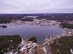
Roberts Arm is a small town located near Crescent Lake, Newfoundland and Labrador, Canada in Division No. 8, Newfoundland and Labrador. It is found on the northern part of Newfoundland. Roberts Arm boasts of its Lake Monster, Cressie, which is claimed to be living in Crescent Lake. Recent years saw the development of a hiking trail which encompasses the end of the lake nearest to the community, Hazelnut Adventure Trail.

Contents

History

Up until the early 20th century Roberts Arm was known as Rabbits Arm, due to a large presence of snowshoe hare in the area. The town is supposedly named after John Roberts, an influential landowner in the area. Logging was the main source of revenue for the town. In 1937, Bowater began operations in Roberts Arm, which led to a significant population increase.

The Roberts Arm strike occurred due to low wages and poor camp conditions. Bowater workers were being paid $2.00 per cord, compared to other areas in Newfoundland and Labrador where workers were paid $2.50 per chord. The strike ended when Sir Eric Bowater threatened to cease operations in Roberts Arm, those on strike returned to work afterwards for the same pay. [1]

Demographics

In the 2021 Census of Population conducted by Statistics Canada, Robert's Arm had a population of 722 living in 351 of its 385 total private dwellings, a change of

See also

References

  1. Canada, Come Explore. "Roberts Arm, Newfoundland and Labrador Canada". Come Explore Canada. Retrieved 2025-12-25.
  2. Canada 2016 Census: Community Profile, Statistics Canada. Accessed February 6, 2018
  3. "Population and dwelling counts: Canada, provinces and territories, census divisions and census subdivisions (municipalities), Newfoundland and Labrador". Statistics Canada. February 9, 2022. Retrieved March 15, 2022.

49°29′17″N55°48′39″W / 49.48806°N 55.81083°W / 49.48806; -55.81083