Cupids

Last updated

Cupids
Town
Townofcupids.jpg
Cupids.JPG
Canada Newfoundland location map.svg
Red pog.svg
Cupids
Location of Cupids in Newfoundland
Coordinates: 47°32′52″N53°13′28″W / 47.5478°N 53.2244°W / 47.5478; -53.2244 Coordinates: 47°32′52″N53°13′28″W / 47.5478°N 53.2244°W / 47.5478; -53.2244
Country Flag of Canada (Pantone).svg  Canada
Province Flag of Newfoundland and Labrador.svg  Newfoundland and Labrador
Settled1610
Government
  MayorCarl Butler
Area
[1]
  Land11.02 km2 (4.25 sq mi)
Population
 (2021) [2]
  Total699
Time zone UTC-3:30 (Newfoundland Time)
  Summer (DST) UTC-2:30 (Newfoundland Daylight)
Area code 709
Highways NL Route 60.svg Route 60
NL Route 70.svg Route 70
NL Route 71.svg Route 71

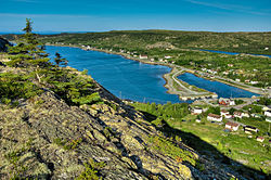
Cupids is a town of 699 people (per the 2021 Census [2] ) on Conception Bay, Newfoundland and Labrador, Canada. It has also been known as Coopers, Copers Cove, Cupers Cove, and Cuperts. It is the oldest continuously settled official British colony in Canada. Cupids is believed to be the site of the first child born of European parents in the country. [3] The town was established by Englishman John Guy in 1610. [3]

Contents

In November 2009, the community was visited by The Prince of Wales and The Duchess of Cornwall. In August 2010, the community was visited by many people from around the world to celebrate the Cupids 400th anniversary, including Canadian Governor General Michaëlle Jean. On August 17, 2010, Canada Post released a commemorative stamp in honour of the founding of the community. [4]

2010 also saw the opening of the Cupids Legacy Centre. This facility includes a world class museum, archeology lab, Faerie Garden, Family History archive, Legacy Hall (a modern 2000 square foot open space), and a spacious boardroom.

Demographics

In the 2021 Census of Population conducted by Statistics Canada, Cupids had a population of 699 living in 325 of its 428 total private dwellings, a change of

Arts and culture

Cupids is home to Perchance Theatre. [5]

See also

Related Research Articles

<span class="mw-page-title-main">Avondale, Newfoundland and Labrador</span> Town in Newfoundland and Labrador, Canada

Avondale is a town located on Newfoundland's Avalon Peninsula in the province of Newfoundland and Labrador, Canada.

Colliers is a town on the Avalon Peninsula in Newfoundland and Labrador, Canada. It is in Division 1 on Conception Bay.

<span class="mw-page-title-main">Gambo, Newfoundland and Labrador</span> Town in Newfoundland and Labrador, Canada

Gambo is a town and designated place in the Canadian province of Newfoundland and Labrador. It is in the northeastern portion of the island of Newfoundland on Freshwater Bay. It is in Division No. 7.

<span class="mw-page-title-main">Division No. 1, Newfoundland and Labrador</span> Census division in Newfoundland and Labrador, Canada

Division 1, Newfoundland and Labrador is a census division covering the entire Avalon Peninsula including the Isthmus of Avalon of the Canadian province of Newfoundland and Labrador. Like all census divisions in Newfoundland and Labrador, but unlike the census divisions of some other provinces, the division exists only as a statistical division for census data, and is not a political entity.

<span class="mw-page-title-main">Portugal Cove–St. Philip's</span> Town in Newfoundland and Labrador, Canada

Portugal Cove–St. Philip's is a rural seashore community located on the eastern Avalon Peninsula of Newfoundland in the province of Newfoundland and Labrador, Canada. The town is a bedroom community of the provincial capital of St. John's.

Brigus is a small fishing community located in Conception Bay, Newfoundland and Labrador, Canada. Brigus was home to Captain Bob Bartlett and the location of his residence Hawthorne Cottage.

<span class="mw-page-title-main">Sandy Cove, Newfoundland and Labrador</span> Town in Newfoundland and Labrador, Canada

Sandy Cove is a town located on the Eastport Peninsula in Newfoundland and Labrador, Canada. It is located on Newman Sound, which is part of Bonavista Bay. It had a population of 120 in the 2021 census.

Musgrave Harbour is a town and designated place in the Canadian province of Newfoundland and Labrador.

<span class="mw-page-title-main">Elliston, Newfoundland and Labrador</span> Town in Newfoundland and Labrador, Canada

Elliston is an incorporated fishing settlement situated on the Bonavista Peninsula of Newfoundland, Canada. Incorporated in 1965, the town of Elliston was once called Bird Island Cove and it is composed of a number of communities, North Side, Noder Cover, Elliston Centre, Elliston Point, Porter's Point, Sandy Cove, The Neck and Maberly. Elliston is known as the Root Cellar Capital of the World and has claimed that title from the 135 root cellars that exist in the community.

Sheaves Cove is a local service district and designated place in the Canadian province of Newfoundland and Labrador. It is on the Port au Port Peninsula along the shore of St. George's Bay. There is a small tourist alcove just off the highway where views of the waterfalls and the ocean are visited often.

Bird Cove is a town in the Canadian province of Newfoundland and Labrador.

Brent's Cove is a town in the Canadian province of Newfoundland and Labrador.

<span class="mw-page-title-main">Cox's Cove</span> Town in Newfoundland and Labrador, Canada

Cox's Cove is a town in the Canadian province of Newfoundland and Labrador. The town had a population of 664 in the Canada 2021 Census. The small community is mainly based on the fishery, mink farm, and construction industries.

Lord's Cove is a town in the Canadian province of Newfoundland and Labrador. The town had a population of 155 in the Canada 2021 Census. Lord's Cove has a rich inshore fishing history and heritage. The town is approximately 65 km southeast of Marystown.

South River is an incorporated municipality in the Canadian province of Newfoundland and Labrador, located at the south-southeast side of Bay de Grave, in Conception Bay. The town had a population of 674 according to the 2021 Canadian Census. South River is the site of the western terminus of Newfoundland and Labrador Route 60, also known as the Conception Bay Highway, which proceeds eastward to downtown St. John's. The river itself forms a natural boundary with neighbouring Clarke's Beach and is a scheduled salmon river. A second river, known as the Gould Brook, forms another natural boundary with the unincorporated local service district of Makinsons. South River is home to the Bay de Grave Regional Fire Department, a first step in developing successful regional cooperation amongst municipalities.

Norman's Cove-Long Cove is a town in the Canadian province of Newfoundland and Labrador. The town had a population of 647 in the Canada 2021 Census, down from 720 in 2011.

Spillars Cove is a local service district and designated place in the Canadian province of Newfoundland and Labrador. It is just outside Bonavista.

<span class="mw-page-title-main">Birchy Cove</span>

Birchy Cove is a local service district and designated place in the Canadian province of Newfoundland and Labrador.

Diamond Cove is a local service district and designated place in the Canadian province of Newfoundland and Labrador.

Knights Cove - Stock Cove is a designated place in the Canadian province of Newfoundland and Labrador.

References

  1. "Census Profile, 2016 Census: Cupids, Town [Census subdivision], Newfoundland and Labrador". Statistics Canada. 8 February 2017. Retrieved October 25, 2019.
  2. 1 2 3 "Population and dwelling counts: Canada, provinces and territories, census divisions and census subdivisions (municipalities), Newfoundland and Labrador". Statistics Canada. February 9, 2022. Retrieved March 15, 2022.
  3. 1 2 "Cupids, Canada's Oldest British Colony". Archived from the original on 2009-09-03. Retrieved 2010-06-29.
  4. Canada Post, Details/en détail, vol. 19, no. 3 (July to September 2010), p. 17.
  5. "Perchance Theatre - Cupids". Newfoundland and Labrador, Canada – Official Tourism Website. Retrieved 2018-03-23.