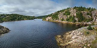
The Town of North River is located northwest of Clarke's Beach, Conception Bay, Newfoundland. The settlement extends along the northwest bank of the river of the same name, and includes Halls Town, located south of what was formerly Fillier's Bridge, further inland along the river valley.
History
In the early 1600s, colonist John Guy of the Cupids plantation referred to people living in the Clarke's Beach area, which could have included North River or South River. Permanent settlement, however, most likely started in the mid 1800s. Historically, what is now called North River was known as Northern Gut, while the name North Valley also appears on some maps.[1]
North River has traditionally been a fishing and agricultural community. It is probable that Northern Gut and the valley of the North River as far inland as The Pond That Feeds the Brook were early sites of winter houses or summer gardens for fishing communities on the Port de Grave peninsula. Many of the year-round settlers in the North River valley were fishermen of Irish descent who had been employed by English merchants and planters on the Peninsula. Local oral tradition holds that the early Roman Catholic settlers had been driven out of the Peninsula, but it is more likely that by the mid 1800s, the families of the original Irish fishing servants had saved enough money to facilitate a move to the riverside farmlands, where they already cultivated gardens.
The census records published in the Journal of the Legislative Council of the Island of Newfoundland for 1833 noted that there were 36 dwelling houses in Northern Gut at that point, with 101 men, 103 women, 27 servants, and 4 fishing boats.[2]
Grave markers in the North River cemetery date back to 1870, but many of the original Irish settlers were buried in the older cemeteries of Bareneed and Port de Grave.
Access to North River was originally always by water, but in 1836 a road was built from Northern Gut to Collier's Bay (today's Colliers). This road joined up with the road from Collier's Bay to Holyrood, providing the first land transportation link into Conception Bay North.[3] The local Road Commissioners at the time were Thomas Ridley, Thomas Chancey, John Elson, and John Stark. In the same year, tenders were called for the building of a road northward, stretching from Northern Gut to Riverhead, Harbour Grace. The bridge over North River was completed around the same time, at a cost of £100.[4]
In 1839, Joseph Jukes, an English geologist and surveyor for Newfoundland, made a visit to Northern Gut while exploring local slate deposits. For June 21st, 1839, Jukes wrote the following in his diary:
Here a brook empties itself into the sea having run for about three miles through a narrow pond or “cosh” as my men called it. We hauled the boat up the shallow bed of the brook for a few yards into deeper water and then rowed up the lake. I then struck off with two men and the theodolite and barometer to the top of a hill on the north side called “Sunday's hill” whose height I found to be about 500 feet.[5]
Improved roads and an influx of settlers meant that by 1840 there was enough settlement in the Valley to justify the establishment of a Roman Catholic school.
North River, undated photo, 19th century.
By 1857, the combined population of Hall's Town and North River was 335, with Roman Catholic families clustered at North River. Protestants (most notably the Hall family) settled further inland.[6] While early settlers chose the area for agricultural purposes, a group of later settlers moved into the area as waterfront property at Clarke's Beach became limited. By the 1860s, residents were combining farming with the Labrador fishery out of Port de Grave and Bay Roberts. Some of the nineteenth century pioneer families moved away to Philadelphia and Boston, but quite a number stayed on.
In 1870–1871, the following family names were in North River: Atkins; Brine; Butler; Cooney; Cullen; Cummins; English; Farrell; Hanlin; Hurley; Kavanagh; Lawless; Long; Moore; Morgan; Morrisy; Neville; O’Brien; Power; Ring; Shea; Sinclair; Skean; Swords; and Walsh. They were all listed as fishermen, planters, and farmers.[7]
The Labrador fishery, farming, and woods work provided most work for late nineteenth-century residents.
The Bell Island mines offered a new type of employment starting in the early 1900s, and in the 1940s many also worked on the construction of the United States base at Argentia.[8]
At this time, Bern English opened the first shop in North River.[citation needed]
Family farming for household needs remained an important tradition in the area well into the twentieth century. In 1986, Clarke's Beach merchant Garfield Ralph remembered locals growing “thousands of barrels of potatoes a year. When I was a boy everybody in Clarke's Beach, North River and South River grew from 10 to 150 barrels of potatoes."[9]
Early family names of North River still common in 1992 included Bradbury, Fillier, Hall, Hanlon, Morgan, Morrissey, Newell, Power, and Snow.[1]
Demographics
In the 2021 Census of Population conducted by Statistics Canada, North River had a population of 579 living in 261 of its 318 total private dwellings, a change of 1.6% from its 2016 population of 570. With a land area of 4.2km2 (1.6sqmi), it had a population density of 137.9/km2 (357.0/sqmi) in 2021.[10]
Avondale is a town located on Newfoundland's Avalon Peninsula in the province of Newfoundland and Labrador, Canada.
Clarenville is a town on the east coast of Newfoundland in the province of Newfoundland and Labrador, Canada. Clarenville was incorporated in 1951. It is located in the Shoal Harbour valley, fronting an arm of the Atlantic Ocean called Random Sound.
Division 1, Newfoundland and Labrador is a census division covering the entire Avalon Peninsula including the Isthmus of Avalon of the Canadian province of Newfoundland and Labrador. Like all census divisions in Newfoundland and Labrador, but unlike the census divisions of some other provinces, the division exists only as a statistical division for census data, and is not a political entity.
Twillingate is a town of 2,121 people located on the Twillingate Islands ("Toulinquet") in Notre Dame Bay, off the north eastern shore of the island of Newfoundland in the province of Newfoundland and Labrador, Canada. The town is about 100 kilometres (62 mi) north of Lewisporte and Gander.
Conception Bay South is a town located on the southern shore of Conception Bay on the Avalon Peninsula of the island of Newfoundland, Province of Newfoundland and Labrador, Canada. The town is commonly called C.B.S. Conception Bay South is the second largest settlement in Newfoundland and Labrador and is part of the St. John's Metropolitan Area.
Caplin Cove is a small community on the north shore of Conception Bay, Newfoundland and Labrador, Canada. It is surrounded on the north by Low Point near the end of the Bay de Verde Peninsula, and on the south by Lower Island Cove. Caplin Cove was probably named for the large body of capelin in its waters.
The Bay de Verde Peninsula is the largest peninsula that makes up part of the Avalon Peninsula, of the province of Newfoundland and Labrador, Canada. The peninsula separates both Trinity and Conception Bay.
Victoria is an incorporated town in Conception Bay located approximately midway on the Bay de Verde Peninsula of Newfoundland and Labrador, Canada.
Harbour Grace is a town in Conception Bay on the Avalon Peninsula in the province of Newfoundland and Labrador, Canada. With roots dating back to the 16th century, it is one of the oldest towns in North America.
Northern Bay is a small community on the northern tip of Conception Bay on the Bay de Verde Peninsula, Subdivision 1G, Newfoundland and Labrador, Canada.
Port de Grave is a peninsula on Conception Bay (CB) in Newfoundland and Labrador, Canada. The peninsula contains the communities of Bareneed, Black Duck Pond, Otterbury, Ship Cove, Blow Me Down, Hibb's Cove, Pick Eyes, and Hussey's Cove with a population of approximately 975 (2006). This community is located in the provincial electoral district of Port de Grave. An unincorporated area, for statistics purposes it is called Division No. 1, Subdivision L. The Peninsula is accessible by road via Route 72.
Bay de Verde is an incorporated town in Conception Bay on the northern tip of the Bay de Verde Peninsula of Newfoundland and Labrador, Canada. The first recorded inhabitants at Bay de Verde arrived in 1662. Bay de Verde became an incorporated town in 1950.
Bay Roberts is located on the north shore of Conception Bay on the northeastern Avalon Peninsula in the province of Newfoundland and Labrador, Canada. The growth of the local economy can be connected to the town's proximity to other major Newfoundland markets, by road and by water.
Admirals Beach is a rural community located in Newfoundland and Labrador, Canada.
Clarke's Beach is a town on Conception Bay in the Canadian province of Newfoundland and Labrador. In the 2021 census the town had a population of 1,400. It is the home of a number of well-known Newfoundland artists, and is a favourite place for retirement.
South River is an incorporated municipality in the Canadian province of Newfoundland and Labrador, located at the south-southeast side of Bay de Grave, in Conception Bay. The town had a population of 674 according to the 2021 Canadian Census. South River is the site of the western terminus of Newfoundland and Labrador Route 60, also known as the Conception Bay Highway, which proceeds eastward to downtown St. John's. The river itself forms a natural boundary with neighbouring Clarke's Beach and is a scheduled salmon river. A second river, known as the Gould Brook, forms another natural boundary with the unincorporated local service district of Makinsons. South River is home to the Bay de Grave Regional Fire Department, a first step in developing successful regional cooperation amongst municipalities.
NunatuKavut is an unrecognized Inuit territory in Labrador. The NunatuKavut people are the direct descendants of the Inuit that lived south of the Churchill or Grand River prior to European contact, with European influence from Basque and French whalers.
Division No. 1, Subdivision G is an unorganized subdivision on the Avalon Peninsula in Newfoundland and Labrador, Canada. It is in Division 1 and contains the unincorporated communities of Baccalieu Island, Besom Cove, Bradley's Cove, Burnt Point, Caplin Cove, Daniel's Cove, Grates Cove, Gull Island, Job's Cove, Kingston, Long Beach, Lower Island Cove, Low Point, Northern Bay, Ochre Pit Cove, Red Head Cove, Riverhead, Smooth Cove and Western Bay.
Division No. 1, Subdivision L is an unorganized subdivision on the Avalon Peninsula in Newfoundland and Labrador, Canada. It is in Division 1 and contains the unincorporated communities of Bareneed, Black Duck Pond, Blow Me Down, Coley's Point South, Hibb's Cove, Pick Eyes, Port de Grave, Ship Cove and The Dock
Caplin Cove-Southport is a local service district and designated place in Trinity Bay in the Canadian province of Newfoundland and Labrador. Caplin Cove-Southport is approximately 50km from Clarenville.
↑ Journal of the Legislative Council of the Island of Newfoundland. Newfoundland House of Assembly and Legislative Council Documents/Centre for Newfoundland Studies. 1833.
↑ Hibbs, Richard (October 1940). ""First Roads Built in Newfoundland: Lecture given by Richard Hibbs, JP, before Newfoundland Historical Society, April 12, 1940". Newfoundland Quarterly. 40.2: 29–32.
↑ Journal of the House of Assembly of Newfoundland 1837. St. John's: Newfoundland House of Assembly. 1837.
This page is based on this Wikipedia article Text is available under the CC BY-SA 4.0 license; additional terms may apply. Images, videos and audio are available under their respective licenses.