Hampden, Newfoundland and Labrador

Last updated
Hampden
Town
Hampden White Bay Newfoundland Canada DSC 3228.jpg
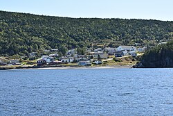
Hampden from the White Bay
Canada Newfoundland location map.svg
Red pog.svg
Hampden
Location of Hampden in Newfoundland
Canada location map 2.svg
Red pog.svg
Hampden
Location of Hampden in Canada
Coordinates: 49°31′59″N56°52′01″W / 49.533°N 56.867°W / 49.533; -56.867
Country Flag of Canada (Pantone).svg  Canada
Province Flag of Newfoundland and Labrador.svg  Newfoundland and Labrador
The Town of HampdenDecember 1959
Named for John Hampden
Government
  MayorCalvin Wilton
  Member of the Newfoundland & Labrador House of Assembly Andrew Furey (LIB)
  Members of the Canadian House of Commons Gudie Hutchings (LIB)
Area
  Total32.9 km2 (12.7 sq mi)
Elevation
100 m (300 ft)
Population
 (2021)
  Total439
Time zone UTC-3:30 (Newfoundland Time)
  Summer (DST) UTC-2:30 (Newfoundland Daylight)
Postal Code
A0K 2Y0
Area code(s) 709
Highways NL Route 421.svg Route 421

Hampden is a town in the Canadian province of Newfoundland and Labrador. The town has a population of 429. Two islands can be seen from the shore of Hampden, Granby Island and Millers Island. The latter is much closer to the town and is the host of a tuberculosis grave-site. [1]

Contents

History

Hampden was named after English politician John Hampden.

Many communities were resettled into Hampden after the island was brought into Canadian Confederation on 31 March 1949, where the Joey Smallwood government pushed a resettlement plan that involved over 300 villages and 28,000 people. [2]

Hampden was and still is to this day a logging and lumber town. Over the years many companies cut logs for lumber mills and pulpwood for paper mills. Thousands of cords of wood was boomed to the Bottom(furthest point south in White Bay) at an early time (1920s - 1930s) it was debarked and loaded aboard ships for England for the International Paper Company of Newfoundland. Later (1940s - 1970s) it was loaded on to trucks and brought to the Humber River at Riverside where it was dumped into the river and floated down the river to the Bowater’s Paper Mill in Corner Brook.

To this day Hampden still relies of the logging industry as it main source of employment, Burton’s Cove Logging and Lumber Limited is the largest employer in the White Bay South area, employing forty plus employees year round.

Demographics

In the 2021 Census of Population conducted by Statistics Canada, Hampden had a population of 439 living in 196 of its 217 total private dwellings, a change of

See also

Related Research Articles

Glovertown is a town in northeastern Newfoundland, Newfoundland and Labrador, Canada. It is in Division No. 7 on Alexander Bay.

Gambo, Newfoundland and Labrador Town in Newfoundland and Labrador, Canada

Gambo is a town and designated place in the Canadian province of Newfoundland and Labrador. It is in the northeastern portion of the island of Newfoundland on Freshwater Bay. It is in Division No. 7.

Badger is a town in north-central Newfoundland, Newfoundland and Labrador, Canada on the Exploits River. It supplied pulp and paper for the mills in Grand Falls for many years and was famous for its large spring log drives. The town is located in the interior of the island, twenty miles west of Grand Falls in Division No. 6. Badger was incorporated as a Town on September 30, 1963.

Lewisporte Town in Newfoundland and Labrador, Canada

Lewisporte is a town in central Newfoundland, Canada, with a population of 3,409. It is situated in Burnt Bay which opens on to the Bay of Exploits. Lewisporte has a deep water port and related facilities that serve many communities in the region.

Burlington is an incorporated town in Newfoundland and Labrador, Canada. It is a small fishing and lumbering community on Route 413 at the north side of the mouth of Green Bay. Burlington is located approximately 40 km from Baie Verte.

Port Hope Simpson Town in Newfoundland and Labrador, Canada

Port Hope Simpson is a town located on the southeastern Labrador coast, 215 km (134 mi) from the Quebec/Labrador border in Canada. It was founded in 1934 as a company town.

Triton is a town that lies on Big Triton Island just off the coast of northeastern Newfoundland, in the Canadian province of Newfoundland and Labrador. Triton is the economic center of Green Bay South. According to Statistics Canada, Triton's population fell from 983 in 2016 to 896 in 2021. The town of Triton has grown more with new businesses and buildings opening in 2017. Triton also has a state of the art swimming pool, skatepark and a small basketball court, there are trailer campsites nearby too.

Red Harbour is a Canadian municipality of Newfoundland and Labrador. It is located 20 kilometres northeast of Marystown.

Dover is a small incorporated fishing and lumbering village located in a small cove at the head of Freshwater Bay, Bonavista Bay, Newfoundland, Canada. Settled in the early 1890s it was originally known as Shoal Bay, presumably from its many shallow coves and inlets in the area. From the 1950s to the 1970 Shoal Bay was referred to as Wellington , whereas the local residents called it Dover.

Campbellton, Newfoundland and Labrador Town in Newfoundland and Labrador, Canada

Campbellton is a small lumbering and fishing community located on the island of Newfoundland at Indian Arm, Notre Dame Bay. The community was originally named Indian Arm due to a Beothuk village located on the nearby Indian Arm River. It was renamed to Campbellton in honor of the sawmill manager John Campbell.

Nippers Harbour Town in Newfoundland and Labrador, Canada

Nipper's Harbour is a town located on the east coast of the Baie Verte Peninsula of Newfoundland in the Canadian province of Newfoundland and Labrador. This incorporated community of 85 people is located on a rocky inlet that combines Nipper's Harbour and Noble's Cove, and where the primary industry is the inshore fishery. The town is approximately 58 km from Baie Verte.

New-Wes-Valley is a municipality in Newfoundland and Labrador, Canada.

Admirals Beach is a rural community located in Newfoundland and Labrador, Canada.

Indian Bay is located in Newfoundland, Canada.

Birchy Bay Town in Newfoundland and Labrador, Canada

Birchy Bay is a small community found in Notre Dame Bay in the province of Newfoundland and Labrador, Canada.

Clarkes Beach Town in Newfoundland and Labrador, Canada

Clarke's Beach is a town on Conception Bay in the Canadian province of Newfoundland and Labrador. In the 2021 census the town had a population of 1,400. It is the home of a number of well-known Newfoundland artists, and is a favourite place for retirement.

Centreville-Wareham-Trinity Town in Newfoundland and Labrador, Canada

Centreville–Wareham–Trinity is a town in the Canadian province of Newfoundland and Labrador, located on Bonavista Bay. The town had a population of 1,116 in the Canada 2021 Census, down from 1,147 in 2016.

Humber Arm South Town in Newfoundland and Labrador, Canada

Humber Arm South is a town in the Canadian province of Newfoundland and Labrador. The town had a population of 1,599 in the Canada 2016 Census. The Town's Post Office is located in the section of the town referred to as Benoit's Cove. Humber Arm South is located in the Bay of Islands, and is in the Humber-Bay of Islands electoral district.

Seal Cove is a town in the Canadian province of Newfoundland and Labrador, located on Fortune Bay. The town had a population of 100 in the 2021 Census. The population of Seal Cove, Fortune Bay has fallen to approximately 100 largely due to outmigration for education and other work-related pursuits. The town was incorporated in 1972.

Sops Arm

Sop's Arm is a local service district and designated place in the Canadian province of Newfoundland and Labrador. The community was formed in the 1930s and 1940s by families moving from surrounding communities, including Jackson's Arm. In the 1950s and 1960s families from nearby Sop's Island moved to Sop's Arm, towing their houses across the channel of water.

References

  1. "GC6PMMW Sojourn #8 - Miller's Island Graveyard (Traditional Cache) in Newfoundland and Labrador, Canada created by Calcorian". Geocaching.com. Retrieved 2022-05-03.
  2. "Introduction". Mun.ca. 1957-10-29. Retrieved 2022-05-03.
  3. "Population and dwelling counts: Canada, provinces and territories, census divisions and census subdivisions (municipalities), Newfoundland and Labrador". Statistics Canada. February 9, 2022. Retrieved March 15, 2022.