Clarenville is a town on the east coast of Newfoundland in the province of Newfoundland and Labrador, Canada. Clarenville was incorporated in 1951. It is located in the Shoal Harbour valley, fronting an arm of the Atlantic Ocean called Random Sound.

St. Anthony is a town on the northern reaches of the Great Northern Peninsula of the Canadian province of Newfoundland and Labrador. St. Anthony serves as a main service centre for northern Newfoundland and southern Labrador. St. Anthony had a population of 2,180 in 2021, compared with 2,258 in 2016, 2,418 in 2011, 2,476 in 2006 and 2,730 in 2001.

Twillingate is a town of 2,121 people located on the Twillingate Islands ("Toulinquet") in Notre Dame Bay, off the north eastern shore of the island of Newfoundland in the province of Newfoundland and Labrador, Canada. The town is about 100 kilometres (62 mi) north of Lewisporte and Gander.

Grand Bank or 'Grand Banc' as the first French settlers pronounced it, is a small rural town in the Canadian province of Newfoundland and Labrador, with a population of 2,580. It is located on the southern tip or "toe" of the Burin Peninsula, 360 km from the province's capital of St. John's.
Brigus is a small fishing community located in Conception Bay, Newfoundland and Labrador, Canada. Brigus was home to Captain Bob Bartlett and the location of his residence Hawthorne Cottage.
Brigus South is a local service district and designated place in the Canadian province of Newfoundland and Labrador on the Avalon Peninsula.
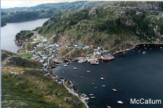
McCallum is a local service district and designated place in the Canadian province of Newfoundland and Labrador. It is on the southern coast of the island of Newfoundland. It is accessible only by boat or by air, and in appearance and way of life is thought by some to be as close to a pre-20th century community as may be found. McCallum lies in an enclosed harbour and is sheltered between two hills. The community survives primarily on the fishery. Whaling was also a major industry in the late 19th century. It is also about an hour and a half from the nearest road, in a community called Hermitage.
Conche is a community on the Northern Peninsula of Newfoundland and Labrador, Canada. Its population in 2021 was 149.
Triton is a town that lies on Triton Island just off the coast of northeastern Newfoundland, in the Canadian province of Newfoundland and Labrador. Triton is the economic center of Green Bay South. According to Statistics Canada, Triton's population fell from 983 in 2016 to 896 in 2021.
Garden Cove is a local service district and designated place in the Canadian province of Newfoundland and Labrador. It is southeast of Swift Current. The residents of Sound Island moved without government assistance during a period around 1953. They moved to the mainland into Garden Cove and surrounding communities. Today Garden Cove has an active close community. There is a tour boat, Merasheen which is part of the Woody Island Resort hotel which gives people a Newfoundland outport experience. Garden Cove has hiking trails passing by Big Rock Hill and Placentiamans Point. There is an inshore fishery operating there. Some species caught are lobster, cod, mackerel, herring, crab, scallops, mussels, flounder and trout. Late in summer Tuna chase bill fish just off shore.

Rose Blanche – Harbour le Cou is a small town on Newfoundland's southwest shore, about 45 km at the end of Route 470 from Port aux Basques. This community is located in a barren area on the east side of a small bay. In this bay there are 2 harbours that were mainly used to provide shelter for fishing vessels. Scenery includes the rugged granite coastline, and the white and rocky cliffs of "Diamond Cove". Its granite lighthouse was in operation from 1873 to the 1940s. After it was abandoned in the 1940s the building fell into ruins. The spiral stone staircase extends into the tower wall and kept the tower from collapsing while the remainder of the lighthouse fell to ruin. In 1999 the lighthouse was fully reconstructed and serves as a tourist attraction.
Musgrave Harbour is a town and designated place in the Canadian province of Newfoundland and Labrador.

Bay Bulls is a small fishing town in the province of Newfoundland and Labrador, Canada.

Fox Harbour is a small community on the Avalon Peninsula of Newfoundland. According to Statistics Canada in 2011, the population was 270. It is surrounded by hills. It is located close to Argentia, the site of the Naval Station Argentia. According to some sources, Fox Harbour got its name from tales of foxes that came down from the surrounding hills and ate the drying fish on the flakes. As well, the community was called Little Glocester before it became officially named Fox Harbour.
Lumsden, formerly known as Cat Harbour, is a community located on the Straight Shore of Newfoundland in Newfoundland and Labrador, Canada, near communities such as Musgrave Harbour and Newtown. Lumsden formerly consisted of two settlements, Lumsden North on the tip of a sandy peninsula and Lumsden South on the main road. Although the harbour in Lumsden is not ideal because it is not sheltered, Lumsden has excellent fishing grounds.

Burnt Islands is a small coastal community found in God Bay on the southwest coast of Newfoundland, Canada.
Fermeuse is a town in the Canadian province of Newfoundland and Labrador. The town had a population of 266 in the Canada 2021 Census.

Salvage is a town located on the Eastport Peninsula of the Canadian province of Newfoundland and Labrador. The town had a population of 108 in the Canada 2021 Census.

Brig Bay is a local service district and designated place in the Canadian province of Newfoundland and Labrador. It was first mapped by Captain James Cook in September 1764. The name "Brig" was adopted by the French who occupied the bay prior to English occupation. It provided a safe and well-sheltered harbour.
Lodge Bay is a local service district and designated place in the Canadian province of Newfoundland and Labrador. It is on the southeast coast of Labrador. Encompassing a population of less than one hundred residents, the community has uniquely evolved from both early European colonization of Labrador, and the inimitable patterns of land and resource use by the migratory Inuit population. The name Lodge Bay originated from the title Ranger Lodge, which was the name given to the area by trader and explorer, Captain George Cartwright in the late 18th century. "Ranger" was the name of the wooden-mercantile ship Cartwright used to trade, map and explore the Labrador coast, while "Lodge" was the name given to English hunting camps in Great Britain at that time.

