Labrador City

Last updated

Labrador City
City
Route 500 Labrador City.jpg
Labradorcity.JPG
Labrador city coat of arms.jpg
Motto(s): 
Kamistiatusset(Naskapi)
(English: "Land of the Hard-Working People")
Canada Newfoundland and Labrador location map 2.svg
Red pog.svg
Labrador City
Location of Labrador City in Labrador
Coordinates: 52°57′N66°55′W / 52.950°N 66.917°W / 52.950; -66.917
Country Flag of Canada (Pantone).svg  Canada
Province Flag of Newfoundland and Labrador.svg  Newfoundland and Labrador
Census division 10
Settled1960s
Government
  TypeLabrador City Town Council
  MayorBelinda Adams [1]
   MHA Jordan Brown
   MP Yvonne Jones
Area
  Total38.83 km2 (14.99 sq mi)
Elevation
555 m (1,821 ft)
Population
 (2021 census) [2]
  Total7,412
  Density186.0/km2 (482/sq mi)
Time zone UTC-4 (AST)
  Summer (DST) UTC-3 (Atlantic Daylight Saving Time)
Postal code span
A2V
Area code 709
Highways NL Route 500.svg Route 500 (Trans-Labrador Highway)
Website www.labradorwest.com

Labrador City is a town in western Labrador (part of the Canadian province of Newfoundland and Labrador), near the Quebec border. [3] With a population of 7,412 as of 2021, it is the second-largest population centre in Labrador, behind Happy Valley-Goose Bay. Neighbouring Labrador City is Wabush, a smaller town with a population of approximately 1,964 as of 2021. [4] Together, the "twin towns" are known as Labrador West.

Contents

In the 1960s, Labrador City was founded to accommodate employees of the Iron Ore Company of Canada, and iron ore mining continues to be the primary industry in the town.

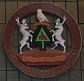
The Labrador City town motto is Kamistiatusset, a Naskapi word meaning "land of the hard-working people." The Labrador City town crest is that of a snowy owl holding a scroll atop a black spade on a mound of red earth. The symbol represents iron ore mining. The spade is flanked by two caribou. Both snowy owls and caribou are native to the Labrador City area.
Government


Since a 2013 by-election, the federal riding of Labrador seat has been held by Yvonne Jones, a Liberal Party member, [5] while New Democrat Jordan Brown has represented Labrador West in the provincial House of Assembly since 2019. [6] [7]

Economy

Labrador City was built around the rich iron ore deposits of the Labrador Trough by the Iron Ore Company of Canada (IOC) in the 1960s. The Carol Project is the major iron ore mining operation for the area. [8] In 2008, IOC and their parent company Rio Tinto announced they would spend $800 million to develop additional mines in the region. However, only a few months after announcing the second phase of their expansion, the project was shelved due to the economic recession and low demand for steel. With the world recovering from the economic crisis, it is believed that IOC will go ahead with their expansion in the near future. [9] [10] [11] [12]

The town is serviced by the Wabush Airport, and the airlines flying out of the airport are Provincial Airlines, Air Inuit and Pascan Aviation. Additionally, the Quebec North Shore and Labrador Railway provides freight rail transportation to and from Sept-Îles. The Trans-Labrador Highway (Route 500) serves as the only road connection to Labrador City, connecting it with the rest of Labrador as well as the neighbouring province of Quebec, becoming Quebec Route 389 at the border.

The town contains many amenities found in larger locations thanks to investments by the mining companies who established the area including an ice arena, curling, downhill & cross country ski clubs. The White wolf snowmobile club connects with a larger trail network across the region and is home to the Cain's Quest Snowmobile Endurance Race.

The main shopping mall in the town, the 22,940-square-metre (246,923 sq ft) Labrador Mall, includes a Walmart, Canadian Tire & Mark's. [13] The mall opened in 1978 and is the largest shopping mall in Labrador; it is also the only enclosed mall. [14] [15] [16] [17]

There is a Masonic lodge in Labrador City, Lodge Anik No 1707 of the District Grand Lodge of Newfoundland and Labrador of the Grand Lodge of Scotland.

Demographics

Historical populations
YearPop.±%
19717,622    
197612,012+57.6%
198111,538−3.9%
19868,665−24.9%
19919,061+4.6%
1996 8,455−6.7%
2001 7,744−8.4%
2006 7,240−6.5%
2011 7,367+1.8%
2016 7,220−2.0%
2021 7,412+2.7%

In the 2021 Census of Population conducted by Statistics Canada, Labrador City had a population of 7,412 living in 3,070 of its 3,368 total private dwellings, a change of

Canada 2016 CensusPopulation % of Total Population
Visible minority group
Source: [19]
South Asian 25
Chinese 25
Filipino 250
Arab 1
Other visible minority10
Mixed visible minority10
Total visible minority population330
Aboriginal group
Source: [20]
First Nations 170
Métis 295
Inuit 125
Other Aboriginal30
Total Aboriginal population630
White 6,230
Total population7,220100%

Attractions

Climate

Wabush and Labrador City have a continental subarctic climate (Köppen: Dfc), with mild summers and severely cold winters. [21] Precipitation is heavy year round (although higher in summer) due to the strong Icelandic Low to the east driving cold, moist and unstable air onto the region. Snowfall, as is typical for the province, is very heavy for seven months each year and depths can reach as high as 218 centimetres (85.83 in). Despite its latitude around the same as cities like Berlin, London, and Amsterdam, its annual mean temperature is 13 °C (23 °F) colder.

Climate data for Wabush (Wabush Airport, normals from 1981−2010)
MonthJanFebMarAprMayJunJulAugSepOctNovDecYear
Record high humidex 7.75.914.616.935.037.139.035.332.222.613.86.539.0
Record high °C (°F)8.0
(46.4)
6.2
(43.2)
14.7
(58.5)
16.8
(62.2)
28.4
(83.1)
33.3
(91.9)
32.6
(90.7)
30.6
(87.1)
27.8
(82.0)
21.1
(70.0)
12.2
(54.0)
5.6
(42.1)
33.3
(91.9)
Mean daily maximum °C (°F)−16.7
(1.9)
−14.2
(6.4)
−6.7
(19.9)
1.5
(34.7)
9.6
(49.3)
16.1
(61.0)
19.1
(66.4)
17.6
(63.7)
11.8
(53.2)
3.8
(38.8)
−4.2
(24.4)
−12.6
(9.3)
2.1
(35.8)
Daily mean °C (°F)−22.2
(−8.0)
−20.6
(−5.1)
−13.3
(8.1)
−4.3
(24.3)
4.0
(39.2)
10.3
(50.5)
13.8
(56.8)
12.5
(54.5)
7.6
(45.7)
0.5
(32.9)
−8.2
(17.2)
−17.5
(0.5)
−3.1
(26.4)
Mean daily minimum °C (°F)−27.8
(−18.0)
−27.0
(−16.6)
−19.8
(−3.6)
−10.0
(14.0)
−1.7
(28.9)
4.4
(39.9)
8.3
(46.9)
7.4
(45.3)
3.3
(37.9)
−2.9
(26.8)
−12.0
(10.4)
−22.5
(−8.5)
−8.4
(16.9)
Record low °C (°F)−45.7
(−50.3)
−47.8
(−54.0)
−46.7
(−52.1)
−37.2
(−35.0)
−21.7
(−7.1)
−11.1
(12.0)
−6.7
(19.9)
−0.6
(30.9)
−7.0
(19.4)
−21.7
(−7.1)
−33.1
(−27.6)
−46.1
(−51.0)
−47.8
(−54.0)
Record low wind chill −62.8−57.1−52.6−41.8−32.6−9.60.0−6.2−13.9−25.6−43.9−59.5−62.8
Average precipitation mm (inches)49.2
(1.94)
40.3
(1.59)
54.1
(2.13)
48.8
(1.92)
53.5
(2.11)
82.7
(3.26)
113.9
(4.48)
103.5
(4.07)
96.5
(3.80)
75.7
(2.98)
70.9
(2.79)
50.4
(1.98)
839.5
(33.05)
Average rainfall mm (inches)0.6
(0.02)
1.6
(0.06)
2.6
(0.10)
12.1
(0.48)
40.4
(1.59)
80.6
(3.17)
113.9
(4.48)
103.4
(4.07)
92.3
(3.63)
42.0
(1.65)
10.9
(0.43)
2.5
(0.10)
502.9
(19.80)
Average snowfall cm (inches)63.8
(25.1)
50.9
(20.0)
65.9
(25.9)
44.3
(17.4)
14.4
(5.7)
2.1
(0.8)
0.0
(0.0)
0.1
(0.0)
4.4
(1.7)
39.0
(15.4)
77.5
(30.5)
66.2
(26.1)
428.7
(168.8)
Average precipitation days (≥ 0.2 mm)17.314.616.014.215.217.119.020.020.520.120.419.3213.7
Average rainy days (≥ 0.2 mm)0.440.781.43.811.916.419.020.019.710.53.91.0109.0
Average snowy days (≥ 0.2 cm)17.715.016.412.36.01.20.040.072.513.919.719.7124.6
Mean monthly sunshine hours 98.0132.2151.3180.1210.6212.5218.0202.7116.675.456.967.31,721.4
Percent possible sunshine 38.647.641.243.143.042.143.044.430.622.921.728.337.2
Source: Environment Canada [22]

See also

Notable residents

Notable former residents of Labrador City include:

Related Research Articles

<span class="mw-page-title-main">Labrador</span> Mainland portion of Newfoundland and Labrador

Labrador is a geographic and cultural region within the Canadian province of Newfoundland and Labrador. It is the primarily continental portion of the province and constitutes 71% of the province's area but is home to only 6% of its population. It is separated from the island of Newfoundland by the Strait of Belle Isle. It is the largest and northernmost geographical region in the four Atlantic provinces.

<span class="mw-page-title-main">Sept-Îles, Quebec</span> City in Quebec, Canada

Sept-Îles is a city in the Côte-Nord region of eastern Quebec. Along with Brador and Blanc-Sablon, Sept-Îles is one of the oldest places in the province. The population was 24,569 as of the 2021 Canadian census. The town is called Uashat, meaning "bay" in Innu-aimun.

<span class="mw-page-title-main">Sparwood</span> District municipality in British Columbia, Canada

Sparwood is a district municipality in the Canadian province of British Columbia. It is the second-largest community on the Elk River.

<span class="mw-page-title-main">Marystown</span> Town in Newfoundland and Labrador, Canada

Marystown is a town in the province of Newfoundland and Labrador, Canada, with a population of around 5,000. Situated 306 km from the province's capital, St. John's, it is on the Burin Peninsula. Until the early 1990s, its economy was largely based on shipbuilding, and it is due in part to this that the town experienced a population increase of 295% in just over a decade. The town was also dependent on the fish plant for employment.

<span class="mw-page-title-main">Wabush Lake Railway</span>

The Wabush Lake Railway is a short line railway operating in the province of Newfoundland and Labrador, Canada.

Labrador West refers to a region in western Labrador in the Canadian province of Newfoundland and Labrador containing the twin towns of Labrador City and Wabush. The area is located in the southwest corner of Labrador, near the Quebec border and has been described as "a dichotomy of pristine wilderness and industrial development."

<span class="mw-page-title-main">Happy Valley-Goose Bay</span> Town in Newfoundland and Labrador, Canada

Happy Valley-Goose Bay is a town in the province of Newfoundland and Labrador, Canada. Located in the central part of Labrador on the coast of Lake Melville and the Churchill River, Happy Valley-Goose Bay is the largest population centre in the region with an estimated 8,040 residents in 2021.

Slovene Canadians are Canadian citizens of Slovene descent or Slovenian-born people who reside in Canada.

<span class="mw-page-title-main">Iron Ore Company of Canada</span> Canadian mining company

Iron Ore Company of Canada is a Canadian-based producer of iron ore. The company was founded in 1949 from a partnership of Canadian and American firms, the largest being the M.A. Hanna Company. It is now owned by a consortium that includes the Mitsubishi and Rio Tinto corporations. Rio Tinto is the majority shareholder in the venture, with 58.7% of the joint stock as of October 2013. Mitsubishi controlled 26.2% of the investment as of March 2013.

<span class="mw-page-title-main">Wabush</span> Town in Newfoundland and Labrador, Canada

Wabush is a small town in the western tip of Labrador, bordering Quebec, known for transportation and iron ore operations.

<span class="mw-page-title-main">Port Hope Simpson</span> Town in Newfoundland and Labrador, Canada

Port Hope Simpson is a town located on the southeastern Labrador coast, 215 km (134 mi) from the Quebec/Southern Labrador border in Canada. In 1944 it was named after John Hope Simpson as a company town.

<span class="mw-page-title-main">Postville, Newfoundland and Labrador</span> Town in Newfoundland and Labrador, Canada

Postville is an Inuit town in the north of Labrador, Canada. It had a population of 188 as of 2021. It is located about 40 km (25 mi) inside Kaipokok Bay, 180 km (110 mi) NNE of Happy Valley-Goose Bay. Postville Airport is nearby.

Norwegian Canadians refer to Canadian citizens who identify themselves as being of full or partial Norwegian ancestry, or people who emigrated from Norway and reside in Canada.

<span class="mw-page-title-main">Demographics of Newfoundland and Labrador</span>

Newfoundland and Labrador is a province of Canada on the country's Atlantic coast in northeastern North America. The province has an area of 405,212 square kilometres and a population in 2024 of 545,247, with approximately 95% of the provincial population residing on the Island of Newfoundland, with more than half of the population residing on the Avalon Peninsula. People from Newfoundland and Labrador are called "Newfoundlanders," "Labradorians", or "Newfoundlanders and Labradorians".

<span class="mw-page-title-main">Point au Gaul</span> Town in Newfoundland and Labrador, Canada

Point au Gaul is a town in the Canadian province of Newfoundland and Labrador, Canada. The town had a population of 67 in the Canada 2021 Census, down from 88 in 2016. Point au Gaul is approximately 76 km southeast of Marystown.

The Quebec North Shore and Labrador Railway is a private Canadian regional railway that stretches 414 kilometres (257 mi) through the wilderness of northeastern Quebec and western Labrador. It connects Labrador City, Labrador, with the port of Sept-Îles, Quebec, on the north shore of the St. Lawrence River. QNS&L is owned by Iron Ore Company of Canada (IOC), and is a common carrier.

Belgian Canadians are Canadian citizens of Belgian ancestry or Belgium-born people who reside in Canada. According to the 2011 census there were 176,615 Canadians who claimed full or partial Belgian ancestry. It encompasses immigrants from both French and Dutch-speaking parts of Belgium.

<span class="mw-page-title-main">Western Labrador Rail Services</span>

Western Labrador Rail Services, Inc. is a rail operation of Genesee & Wyoming Canada, Inc. created in 2010 by the combination of three short line railways: Arnaud Railway, Bloom Lake Railway, and Wabush Lake Railway. The operation provides rail transportation services to mining companies operating in the provinces of Newfoundland and Labrador and Québec, Canada.

<span class="mw-page-title-main">Placentia West-Bellevue</span> Provincial electoral district in Newfoundland and Labrador, Canada

Placentia West-Bellevue is a provincial electoral district in Newfoundland and Labrador, which is represented by one member in the Newfoundland and Labrador House of Assembly. It was contested for the first time in the 2015 provincial election.

Green's Harbour is a local service district and designated place in the Canadian province of Newfoundland and Labrador.

References

  1. Council, retrieved Feb. 23, 2022
  2. "Labrador City, Town [Census subdivision]". www12.statcan.gc.ca. Statistics Canafa. Retrieved 16 September 2019.
  3. Labrador West. "Labrador City". Archived from the original on 2008-12-01. Retrieved 2008-03-13.
  4. "Wabush, Town". www12.statcan.gc.ca. Statistics Canada. 8 February 2017. Retrieved 16 September 2019.
  5. "Liberals take Labrador, as Jones wins big over Penashue". CBC News. 13 May 2013. Retrieved 2 May 2018.
  6. "Cabinet ministers Letto and Hawkins among 9 defeated Liberals". CBC News Newfoundland and Labrador, May 17, 2019.
  7. "Here are all the MHAs elected in the Newfoundland and Labrador election". CBC News. March 27, 2021.
  8. "Labrador West". Archived from the original on 2011-05-27. Retrieved 2009-04-15.
  9. Iron Ore Company announces $500M expansion
  10. Iron Ore Co. announces $300M expansion for Labrador
  11. Iron Ore Co. shelves Labrador expansion
  12. IOC press release - NL 2010 Budget
  13. Page 2 | List of companies in Labrador City, Newfoundland Canada
  14. History of Labrador City Archived 2014-06-06 at the Wayback Machine , LabradorWest.com, Retrieved February 7, 2011
  15. "Labrador Mall - Labrador City - A Scoff an' Scuff". www.ascoffanscuff.com. Archived from the original on 29 September 2007. Retrieved 17 January 2022.
  16. Labrador Mall Archived 2014-06-06 at the Wayback Machine , Westcliff.ca, Retrieved February 7, 2011
  17. (22 November 2010). Concerns turn to action, The Aurora
  18. "Population and dwelling counts: Canada, provinces and territories, census divisions and census subdivisions (municipalities), Newfoundland and Labrador". Statistics Canada. February 9, 2022. Retrieved March 15, 2022.
  19. "Visible minority population". www12.statcan.gc.ca. Statistics Canada. Retrieved 16 September 2019.
  20. "Aboriginal population". www.12.statcan.gc.ca. Statistics Canada. Retrieved 16 September 2019.
  21. "Wabush, Newfoundland and Labrador Köppen Climate Classification (Weatherbase)". Weatherbase. Retrieved 2020-03-24.
  22. "Wabush Lake Airport". Canadian Climate Normals 1981–2010. Environment Canada. 31 October 2011. Retrieved May 23, 2014.
  23. Rothman, Clifford (November 19, 1997). "Back From The Brink". Los Angeles Times . Archived from the original on March 21, 2015.

Commons-logo.svg Media related to Labrador City at Wikimedia Commons

52°57′N66°55′W / 52.950°N 66.917°W / 52.950; -66.917 (Labrador City)