
Newfoundland and Labrador is the easternmost province of Canada, in the country's Atlantic region. It is composed of the island of Newfoundland and the continental region of Labrador to the northwest, with a combined area of 405,212 square kilometres (156,500 sq mi). In 2018, the province's population was estimated at 525,073. About 94% of the province's population lives on the island of Newfoundland, of whom more than half live on the Avalon Peninsula.

St. John's is the capital and largest city of the Canadian province, Newfoundland and Labrador, located on the eastern tip of the Avalon Peninsula on the island of Newfoundland. It is the oldest city in Canada. The city spans 446.04 km2 (172.22 sq mi) and is the easternmost city in North America.
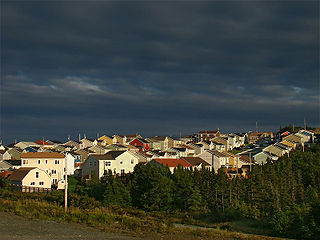
Paradise is a town on the Avalon Peninsula in the province of Newfoundland and Labrador, Canada. The town is a part of the St. John's Metropolitan Area and borders the City of St. John's, the City of Mount Pearl, the Town of Portugal Cove-St. Philip's, and the town of Conception Bay South. According to the 2016 Canadian census the population of Paradise is 21,389, after recording a 21% increase in population over five years.

Lewisporte is a town in central Newfoundland, Canada, with a population of 3,409. It is situated in Burnt Bay which opens on to the Bay of Exploits. Lewisporte has a deep water port and related facilities that serve many communities in the region.

Marystown is a town in the province of Newfoundland and Labrador, Canada, with a population of around 5,000. Situated 306 km from the province's capital, St. John's, it is on the Burin Peninsula. Until the early 1990s, its economy was largely based on shipbuilding, and it is due in part to this that the town experienced a population increase of 295% in just over a decade. The town was also dependent on the fish plant for employment.

Labrador City is a town in western Labrador, near the Quebec border. With a population of 7,220 as of 2016, it is the second-largest population centre in Labrador, behind Happy Valley-Goose Bay. Neighbouring Labrador City is Wabush, a smaller town with a population of approximately 1,906 as of 2016. Together, the "twin towns" are known as Labrador West.

Ramea is a small village in Newfoundland and Labrador located on Northwest Island, one of a group of five major islands located off the south coast of Newfoundland, Canada. The island is approximately 3.14 km long by 0.93 km wide. The other major islands in the archipelago are Great Island, Middle Island, Harbour Island, and South West Island.
The Burin Peninsula is a peninsula located on the south coast of the island of Newfoundland in the province of Newfoundland and Labrador.
Anchor Point is a town located in St. Barbe Bay, south of Flower's Cove on the west side of the Great Northern Peninsula, in Newfoundland and Labrador, Canada. It was the first English settlement on what is called the 'French Shore' of Newfoundland.
Rocky Harbour is a town located on the western edge of Newfoundland, near the entrance to Bonne Bay. The harbour was previously known as Small Bay or Little Harbour. This town is home to Gros Morne National Park, a World Heritage Site.
Dover is a small incorporated fishing and lumbering village located in a small cove at the head of Freshwater Bay, Bonavista Bay, Newfoundland, Canada. Settled in the early 1890s it was originally known as Shoal Bay, presumably from its many shallow coves and inlets in the area. From the 1950s to the 1970 Shoal Bay was referred to as Wellington , whereas the local residents called it Dover.

Point May is the most southerly community on the Burin Peninsula in Newfoundland and Labrador with a population of about 230 people. It is a Catholic community with a church, town hall, fire hall, softball and soccer field. It is known for its close proximity, 19 km (12 mi), to the French islands of St. Pierre and Miquelon, where the smuggling of liquor and tobacco has been a way of life since before Canada was a country. The tiny Canadian Green Island lies 10 km (6 mi) west of Point May, roughly halfway to St. Pierre.

Elliston is an incorporated fishing settlement situated on the Bonavista Peninsula of Newfoundland, Canada. Incorporated in 1965, the town of Elliston was once called Bird Island Cove and it is composed of a number of communities, North Side, Noder Cover, Elliston Centre, Elliston Point, Porter's Point, Sandy Cove, The Neck and Maberly. Elliston is known as the Root Cellar Capital of the world and has claimed that title from the 135 root cellars that exist in the community.
L'Anse-au-Clair is a town in the Labrador portion of Newfoundland and Labrador, Canada. The town has a population of 216 in the 2016 census, up from 192 in 2011.

Cow Head is a town in the Canadian province of Newfoundland and Labrador. The town had a population of 478 in the Canada 2016 Census.

English Harbour East is a town in the Canadian province of Newfoundland and Labrador. It is located on the northeast side of Fortune Bay. Settled first by the Mi’kmaq of Newfoundland which used land on the “Neck” of the Harbour, they were joined in the early 1800s, by the English Dodge family and by Irishman Thomas Hynes Sr. European fishermen were first brought to the small community by English merchant family of Newman and Co. based in Harbour Breton, the firm of merchant John Gorman, and the Jersey firm of Nicholle and Co. The town had a population of 139 in the Canada 2016 Census.

Frenchman's Cove is a town on the west coast of Burin Peninsula, Newfoundland and Labrador, Canada. It had a population of 169 in the Canada 2016 Census, a drop from 172 in 2011. The town has been inhabited since before 1836, the earliest known documentation about it, when it appeared in the first Newfoundland Census. According to local folklore and tradition, the first settlers were named Cleuetts and were of French origin. The small-boat inshore fishery was the economic mainstay of the area until the late 1800s when did men went work on the schooners operating from Grand Bank. Residents also grew turnips, cabbages, and potatoes, as well as hay for their horses, cattle, sheep, and chickens.

L'Anse-au-Loup is a town in the Canadian province of Newfoundland and Labrador. The town had a population of 558 in the Canada 2016 Census, slightly up from 550 in 2011. In the Canada 2006 Census, there were 593 inhabitants. Common Surnames are Barney, Belben, Cabot, Earle, Linstead, Normore, O'Brien, Ryland.
Division No. 2, Newfoundland and Labrador is a census division in the Canadian province of Newfoundland and Labrador, primarily comprising the Burin Peninsula. Like all census divisions in Newfoundland and Labrador, but unlike the census divisions of some other provinces, the division exists only as a statistical division for census data, and is not a political entity.

Milton is a designated place in the Canadian province of Newfoundland and Labrador.

