Conception Harbour is a town on the Avalon Peninsula in Newfoundland and Labrador, Canada. It is in Division 1 on Conception Bay and can be accessed via Newfoundland and Labrador Route 60.

Twillingate is a town of 2,121 people located on the Twillingate Islands ("Toulinquet") in Notre Dame Bay, off the north eastern shore of the island of Newfoundland in the province of Newfoundland and Labrador, Canada. The town is about 100 kilometres (62 mi) north of Lewisporte and Gander.
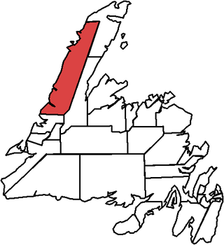
St. Barbe is a defunct provincial electoral district for the House of Assembly of Newfoundland and Labrador, Canada. As of 2011, there were 7,064 eligible voters living within the district. The district was abolished in 2015 and replaced by St. Barbe-L'Anse aux Meadows.
Piccadilly Slant-Abraham's Cove is a local service district and designated place in the Canadian province of Newfoundland and Labrador. It is located on the island of Newfoundland, along St. George's Bay, on the Port au Port Peninsula. The DPL consists of the fishing villages of Abraham's Cove and Piccadilly.
Aspen Cove is a small fishing community in the province of Newfoundland and Labrador, Canada. Formerly called Aspey or Apsey Cove, Aspen Cove was named for the presence of aspen trees in the area. It first appears in the 1857 Census as Apsey Cove with a population of thirteen, all dependent on the salmon fishery. By the 1870s more families moved to Aspen Cove for the cod and lobster fisheries. In the 1921 census the population had reached 104 and the economy had changed from salmon, fur, and agriculture to cod, lobster, and lumbering.
Conche is a community on the Northern Peninsula of Newfoundland and Labrador, Canada. Its population in 2021 was 149.
Garden Cove is a local service district and designated place in the Canadian province of Newfoundland and Labrador. It is southeast of Swift Current. The residents of Sound Island moved without government assistance during a period around 1953. They moved to the mainland into Garden Cove and surrounding communities. Today Garden Cove has an active close community. There is a tour boat, Merasheen which is part of the Woody Island Resort hotel which gives people a Newfoundland outport experience. Garden Cove has hiking trails passing by Big Rock Hill and Placentiamans Point. There is an inshore fishery operating there. Some species caught are lobster, cod, mackerel, herring, crab, scallops, mussels, flounder and trout. Late in summer Tuna chase bill fish just off shore.

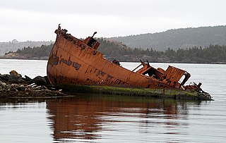
Rencontre East is a small, outport community in Newfoundland and Labrador, Canada located north east of Belleoram, and west of Terrenceville in Fortune Bay. The population was 115 in the 2021 census. This small community is not connected to any surrounding areas by road but is accessible by scheduled ferry service from ports in Pool's Cove and Bay L'Argent.
Carmanville is a Canadian community in the province of Newfoundland and Labrador.
Bay de Verde is an incorporated town in Conception Bay on the northern tip of the Bay de Verde Peninsula of Newfoundland and Labrador, Canada. The first recorded inhabitants at Bay de Verde arrived in 1662. Bay de Verde became an incorporated town in 1950.
Noggin Cove is a local service district and designated place in the Canadian province of Newfoundland and Labrador. It is west of Carmanville on the south side of Hamilton Sound. It is said to be named after Noggin Island, about 5 km off its eastern point.
Ladle Cove is a designated place in the Canadian province of Newfoundland and Labrador. It is along the Straight Shore on the island of Newfoundland.
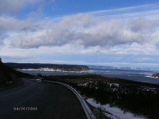
Savage Cove is a community located on the Great Northern Peninsula, north of Flower's Cove on the coast of the Strait of Belle Isle. Savage Cove is the most northerly sheltered harbour in the straits on the island of Newfoundland. In 1996, Savage Cove and nearby Sandy Cove were officially consolidated into the Town of Savage Cove - Sandy Cove.

Coachman's Cove is a town in the Canadian province of Newfoundland and Labrador. The town had a population of 111 in the Canada 2021 Census.

Cox's Cove is a town in the Canadian province of Newfoundland and Labrador. The town had a population of 664 in the Canada 2021 Census. The small community is mainly based on the fishery, mink farm, and construction industries.
Harry's Harbour is a local service district and designated place in the Canadian province of Newfoundland and Labrador. It is southeast of Baie Verte.

Sop's Arm is a local service district and designated place in the Canadian province of Newfoundland and Labrador. The community was formed in the 1930s and 1940s by families moving from surrounding communities, including Jackson's Arm. In the 1950s and 1960s families from nearby Sop's Island moved to Sop's Arm, towing their houses across the channel of water.
Lodge Bay is a local service district and designated place in the Canadian province of Newfoundland and Labrador. It is on the southeast coast of Labrador. Encompassing a population of less than one hundred residents, the community has uniquely evolved from both early European colonization of Labrador, and the inimitable patterns of land and resource use by the migratory Inuit population. The name Lodge Bay originated from the title Ranger Lodge, which was the name given to the area by trader and explorer, Captain George Cartwright in the late 18th century. "Ranger" was the name of the wooden-mercantile ship Cartwright used to trade, map and explore the Labrador coast, while "Lodge" was the name given to English hunting camps in Great Britain at that time.

Division No. 1, Subdivision G is an unorganized subdivision on the Avalon Peninsula in Newfoundland and Labrador, Canada. It is in Division 1 and contains the unincorporated communities of Baccalieu Island, Besom Cove, Bradley's Cove, Burnt Point, Caplin Cove, Daniel's Cove, Grates Cove, Gull Island, Job's Cove, Kingston, Long Beach, Lower Island Cove, Low Point, Northern Bay, Ochre Pit Cove, Red Head Cove, Riverhead, Smooth Cove and Western Bay.
Caplin Cove-Southport is a local service district and designated place in Trinity Bay in the Canadian province of Newfoundland and Labrador. Caplin Cove-Southport is approximately 50 km from Clarenville.


