Fox Harbour, Newfoundland and Labrador

Last updated

Fox Harbour
Town
Fox Harbour, NL Sunset.jpg
Fox Harbour at Sunset, Summer 2009
Canada Newfoundland location map.svg
Red pog.svg
Fox Harbour
Location of Fox Harbour
Canada location map 2.svg
Red pog.svg
Fox Harbour
Fox Harbour (Canada)
Coordinates: 47°19′17″N53°52′58″W / 47.32139°N 53.88278°W / 47.32139; -53.88278
CountryCanada
Province Newfoundland and Labrador
Settledearly 1800s
Incorporated1964
Population
 (2021)
  Total226
Time zone UTC−03:30 (NST)
  Summer (DST) UTC−02:30 (NDT)
Area code 709
Highways NL Route 102.svg Route 102

Fox Harbour is a small community on the Avalon Peninsula of Newfoundland. According to Statistics Canada in 2011, the population was 270. It is surrounded by hills. It is located close to Argentia, the site of the Naval Station Argentia. According to some sources, Fox Harbour got its name from tales of foxes that came down from the surrounding hills and ate the drying fish on the flakes. As well, the community was called Little Glocester before it became officially named Fox Harbour.

Contents

History

Fox Harbour started as a fishing community in the early 19th century by the three families of Matthew, Martin, and George Spurvey. However, fisherman from England and Ireland had come overseas to fish there seasonally since the 18th century. All of them returned to England in the 1820s except for a Matthew Spurvey. Other families had settled in Fox Harbour by then with the arrival of Healey, Kelly and Dreaddy families from Ireland in 1806. The population grew over time, and peaked at 746. Fox Harbour was incorporated in 1964, and the council building opened in 1969. The council building now incorporates the fire station, the library, museum, and the council office.

Demographics

In the 2021 Census of Population conducted by Statistics Canada, Fox Harbour had a population of 226 living in 114 of its 136 total private dwellings, a change of

Religion

The population of Fox Harbour is predominantly Roman Catholic. The Roman Catholic Church, the only church in Fox Harbour, was built in 1890. Before the church was built, the people of Fox Harbour had to boat to Argentia to attend church service. In October, 1919 the original church was torn down and a new church built. In 1945, Fox Harbour became a parish and was called Sacred Heart Parish. Fr. Penny was the first appointed parish priest. Recently the Fox Harbour parish joined with the Placentia area to become the Placentia Area Roman Catholic Cluster.

Education

The first school established in Fox Harbour was in 1848. St. Regis was built in 1946 and expanded in 1956. High school students were initially schooled at Laval High School in Placentia. When St. Anne's Academy was opened, the high school students from St. Regis moved from Laval to St. Anne's which was closer to home. However, in the early 1990s St. Regis closed its doors and all students are now bused to St. Anne's Academy from kindergarten to grade six, and Laval from grade seven to grade twelve.

The Fox Harbour Festival

In 1993 Fox Harbour had its first festival. It has been held every year since then. The festival is held in the last weekend of July.

It commences with a cemetery mass followed by a garden party on the Sunday previous to the festival week. During the following week many events are held, including dances for adults and children, and a concert. On Saturday, there is a softball tournament; all residents over the age of 30 are invited to participate (usually in four teams). The turnout is good and the games are lively. Following the softball game a dance is held that night. On Sunday afternoon, a local variety show is held that includes all the local talent.

Local residents organize the event; they are called the Fox Harbour Festival Committee.

Related Research Articles

<span class="mw-page-title-main">Avondale, Newfoundland and Labrador</span> Town in Newfoundland and Labrador, Canada

Avondale is a town located on Newfoundland's Avalon Peninsula in the province of Newfoundland and Labrador, Canada, which was incorporated in 1974. The community is situated at the southwestern head of Conception Bay in Division 1. It is located 59 km (37 mi) southwest of St. John's and 72 km (45 mi) northeast of Placentia.

<span class="mw-page-title-main">Conception Harbour</span> Town in Newfoundland and Labrador, Canada

Conception Harbour is a town on the Avalon Peninsula in Newfoundland and Labrador, Canada. It is in Division 1 on Conception Bay and can be accessed via Newfoundland and Labrador Route 60.

Whitbourne is a town on the Avalon Peninsula in Newfoundland and Labrador, Canada in Division 1.

Clarenville is a town on the east coast of Newfoundland in the province of Newfoundland and Labrador, Canada. Clarenville was incorporated in 1951. It is located in the Shoal Harbour valley, fronting an arm of the Atlantic Ocean called Random Sound.

<span class="mw-page-title-main">Division No. 1, Newfoundland and Labrador</span> Census division in Newfoundland and Labrador, Canada

Division 1, Newfoundland and Labrador is a census division covering the entire Avalon Peninsula including the Isthmus of Avalon of the Canadian province of Newfoundland and Labrador. Like all census divisions in Newfoundland and Labrador, but unlike the census divisions of some other provinces, the division exists only as a statistical division for census data, and is not a political entity.

Upper Island Cove, Newfoundland and Labrador is a town in Newfoundland and Labrador. It is located in Division 1, Newfoundland and Labrador census division. It is north east of Bay Roberts. The Way office was established in 1864. The population was 942 in 1940; 1,346 in 1951, 1,563 in 1956, and 1762 in 1966. As of 2021, the population is 1,401.

<span class="mw-page-title-main">Placentia, Newfoundland and Labrador</span> Town in Newfoundland and Labrador, Canada

Placentia is a town located in the Canadian province of Newfoundland and Labrador. It consists of the Argentia Industrial Park and amalgamated communities of Townside, Freshwater, Dunville, Southeast, Point Verde and Jerseyside.

<span class="mw-page-title-main">Placentia-St. Mary's</span> Provincial electoral district in Newfoundland and Labrador, Canada

Placentia—St. Mary's is a provincial electoral district for the House of Assembly of Newfoundland and Labrador, Canada. As of 2011, there were 7,361 eligible voters living within the district.

<span class="mw-page-title-main">Grates Cove, Newfoundland and Labrador</span> Local service district / designated place in Newfoundland and Labrador, Canada

Grates Cove is a local service district and designated place in the Canadian province of Newfoundland and Labrador. It is the most northerly community on the Avalon Peninsula, located on the tip of the Bay de Verde Peninsula on the island of Newfoundland. Called "the Grates" by John Guy as early as 1612, the origin of the name is unknown.

<span class="mw-page-title-main">Burin, Newfoundland and Labrador</span> Town in Newfoundland and Labrador, Canada

Burin is a town on the Burin Peninsula in Placentia Bay, Newfoundland and Labrador, Canada. The Burin Peninsula is often affectionately nicknamed "The Boot" due to its resemblance to the footwear when seen on a map, with the town of Burin located near the "heel". Burin is approximately 318 km from the capital of St. John's. Settlement in Burin dates to the early 18th century, although documentary evidence indicates that French fishermen had been fishing and exploring the area even earlier.

<span class="mw-page-title-main">Argentia</span> Commercial Seaport & Industrial Park in Newfoundland and Labrador, Canada

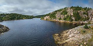
Argentia is a Canadian commercial seaport and industrial park located in the Town of Placentia, Newfoundland and Labrador. It is situated on the southwest coast of the Avalon Peninsula and defined by a triangular shaped headland which reaches northward out into Placentia Bay creating a natural harbour 3 km (1.9 mi) in length.

<span class="mw-page-title-main">Bay Bulls, Newfoundland and Labrador</span> Town in Newfoundland and Labrador, Canada

Bay Bulls is a small fishing town in the province of Newfoundland and Labrador, Canada.

Bay de Verde is an incorporated town in Conception Bay on the northern tip of the Bay de Verde Peninsula of Newfoundland and Labrador, Canada. The first recorded inhabitants at Bay de Verde arrived in 1662. Bay de Verde became an incorporated town in 1950.

<span class="mw-page-title-main">English Harbour East</span> Town in Newfoundland and Labrador, Canada

English Harbour East is a town in the Canadian province of Newfoundland and Labrador. It is located on the northeast side of Fortune Bay. Settled first by the Mi’kmaq of Newfoundland which used land on the "Neck" of the Harbour, they were joined in the early 1800s, by the English Dodge family and by Irishman Thomas Hynes Sr. European fishermen were first brought to the small community by English merchant family of Newman and Co. based in Harbour Breton, the firm of merchant John Gorman, and the Jersey firm of Nicholle and Co. The town had a population of 117 in the Canada 2021 Census.

O'Donnells is a local service district and designated place in the Canadian province of Newfoundland and Labrador. It is southeast of Placentia. The first postmistress was Mrs. Theresa M. Hanlon on July 16, 1951. By 1956 there was a population of 244.

Ship Harbour is a community in Newfoundland and Labrador, Canada located on the eastern shore of Placentia Bay.

<span class="mw-page-title-main">Swells Cove</span> Fishing Cove in Newfoundland and Labrador, Canada

Swells Cove was a small community in Newfoundland and Labrador. It is located near Ship Harbour, Placentia Bay, and is accessible from Ship Harbour through "The American Road".

<span class="mw-page-title-main">Iona, Newfoundland and Labrador, Canada</span> Abandoned Town in Newfoundland and Labrador, Canada

Iona was a small community in Placentia Bay, Newfoundland and Labrador made up of small islands that used to be inhabited. The islands were once called The Ram's or Ram's Islands.

<span class="mw-page-title-main">Little Placentia Sound, Newfoundland and Labrador</span> Abandoned Town in Newfoundland and Labrador, Canada

Little Placentia Sound is an abandoned town in Newfoundland and Labrador that had a peak population of 47 in 1901. It is named after the body of water (sound) that encompasses the former community located within Placentia Bay on the Avalon Peninsula in the Canadian province of Newfoundland and Labrador. There was once a lead mine called Silver Cliff Mine located within the town.

Little Harbour (East) is a local service district and designated place in the Canadian province of Newfoundland and Labrador on the Placentia Bay of the island of Newfoundland.

References

  1. "Population and dwelling counts: Canada, provinces and territories, census divisions and census subdivisions (municipalities), Newfoundland and Labrador". Statistics Canada. February 9, 2022. Retrieved March 15, 2022.