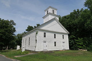
Wendell is a town in Franklin County, Massachusetts, United States. The population was 848 at the 2010 census. It is part of the Springfield, Massachusetts Metropolitan Statistical Area.

Halifax is a town in Plymouth County, Massachusetts, United States. The population was 7,518 at the 2010 census.

Lakeville is a town in Plymouth County, Massachusetts, United States. The population was 10,602 at the 2010 census.

Rochester is a town in Plymouth County, Massachusetts, United States. The population was 5,232 at the 2010 census.

Wareham is a town in Plymouth County, Massachusetts, United States. As of the 2010 census, the town had a population of 21,822.
Wareham has long been recognized as the western point of Cape Cod.

Swampscott is a town in Essex County, Massachusetts, United States located 15 miles (24 km) up the coast from Boston in an area known as the North Shore. The population was 13,787 as of 2010. A former summer resort on Massachusetts Bay, Swampscott is today a fairly affluent residential community and includes the village of Beach Bluff, as well as part of the neighborhood of Clifton. It is known for its quiet suburban character and lovely beaches. The town was home to the scenic ocean front college, Marian Court College until 2015.

Brewster is a town in Barnstable County, Massachusetts, United States, Barnstable County being coextensive with Cape Cod. The population of Brewster was 9,820 at the 2010 census.

Hanson is a town in Plymouth County, Massachusetts, United States and is one of the inland towns of the South Shore. The population was 10,209 at the 2010 census.

Leduc is a city in the province of Alberta, Canada. It is 33 kilometres (21 mi) south of the provincial capital of Edmonton and is part of the Edmonton Metropolitan Region.
Division No. 1, Subdivision M is an unorganized subdivision on the Avalon Peninsula in Newfoundland and Labrador, Canada in Division 1. It contains the unincorporated communities of Emerald Vale, Goulds Road, Juniper Stump, Mahers and Turks Water.
The census geographic units of Canada are the administrative divisions defined and used by Canada's federal government statistics bureau Statistics Canada to conduct the country's five-yearly census. They exist on four levels: the top-level (first-level) divisions are Canada's provinces and territories; these are divided into second-level census divisions, which in turn are divided into third-level census subdivisions and fourth-level dissemination areas.
Subdivision is the act of dividing land into pieces that are easier to sell or otherwise develop, usually via a plat. The former single piece as a whole is then known in the United States as a subdivision. If it is used for housing it is typically known as a housing subdivision or housing development, although some developers tend to call these areas communities.

Natore is a district of Rajshahi Division located in northern Bangladesh. It borders the metropolitan city of Rajshahi, and used to be part of Rajshahi district.
International standard ISO 2145 defines a typographic convention for the "numbering of divisions and subdivisions in written documents". It applies to any kind of document, including manuscripts, books, journal articles, and standards.

Thakurgaon is a district in the north-western side of Bangladesh. It is a part of the Rangpur Division and borders India to the west. It was established as a mahakuma in 1860 consisting of 6 thanas named Thakurgaon sadar, Baliadangi, Pirganj, Ranishankail, Haripur and Ruhia. In 1947, it was re-established as a mahakuma including 3 thanas of Jalpaiguri and a thana of kochbihar of India. In 1981, Atoari was included in the new Panchagarh district and the area was shrunk in just 5 thanas. It was then established as a district in 1 February 1984.
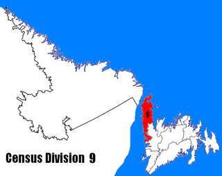
Census Division No. 9 is composed of the area of the province of Newfoundland and Labrador called the Northern Peninsula. It has a land area of 13,526.85 km² and had a population of 16,786 at the 2011 census. The largest community is the town of St. Anthony, near its northern tip, on the Atlantic Ocean coast.
Pine Lake is a 23-acre (93,000 m2) lake in Duxbury, Massachusetts in the village of Tinkertown. The lake is located southwest of Round Pond, northwest of Island Creek Pond, and east of Route 3 near the East Street underpass. The outflow is a small stream that flows into Round Pond. A small subdivision lies along the southern shore of the lake.
Division No. 1, Subdivision L is an unorganized subdivision on the Avalon Peninsula in Newfoundland and Labrador, Canada. It is in Division 1 and contains the unincorporated communities of Bareneed, Black Duck Pond, Blow Me Down, Coley's Point South, Hibb's Cove, Pick Eyes, Port de Grave, Ship Cove and The Dock
The Pond Fork Subdivision is a railroad line owned by CSX Transportation in the U.S. State of West Virginia. It was formerly part of the CSX Huntington East Division. It become part of the CSX Florence Division on June 20, 2016. The line runs from Danville, West Virginia to Harris, West Virginia for a total of 29.1 miles. At its south end it continues north from the Coal River Subdivision and at its north end the track comes to an end.
The Florence Division is a railroad division operated by CSX Transportation in the U.S. states of Georgia, Kentucky, North Carolina, South Carolina, Tennessee, Virginia & West Virginia. The Florence Division has 60 Subdivisions. The Subdivisions in italics came from the Huntington East & Huntington West Divisions effective June 20, 2016.


