You can help expand this article with text translated from the corresponding article in Dutch. Click [show] for important translation instructions.
|
Winterland | |
---|---|
Town | |
Location of Winterland in Newfoundland | |
Coordinates: 47°09′04″N55°18′51″W / 47.15111°N 55.31417°W | |
Country | Canada |
Province | Newfoundland and Labrador |
Population (2021) | |
• Total | 398 |
Time zone | UTC−03:30 (NST) |
• Summer (DST) | UTC−02:30 (NDT) |
Area code | 709 |
Winterland is a town in the Canadian province of Newfoundland and Labrador. The town is considered to be a bedroom community of Marystown.
Winterland has a humid continental climate (Dfb). The seasonal lag is unusual for the Atlantic coast with August being the warmest month and September closer to July than to June. February is the coldest month, especially with low temperatures. Winter lasts from mid-November through early April.
Climate data for Winterland | |||||||||||||
---|---|---|---|---|---|---|---|---|---|---|---|---|---|
Month | Jan | Feb | Mar | Apr | May | Jun | Jul | Aug | Sep | Oct | Nov | Dec | Year |
Record high °C (°F) | 13.0 (55.4) | 14.0 (57.2) | 15.0 (59.0) | 18.0 (64.4) | 24.5 (76.1) | 27.0 (80.6) | 29.5 (85.1) | 30.0 (86.0) | 29.0 (84.2) | 21.5 (70.7) | 18.0 (64.4) | 13.0 (55.4) | 30.0 (86.0) |
Average high °C (°F) | −0.5 (31.1) | −0.6 (30.9) | 1.9 (35.4) | 6.5 (43.7) | 12.2 (54.0) | 16.3 (61.3) | 20.7 (69.3) | 21.3 (70.3) | 17.5 (63.5) | 12.0 (53.6) | 6.8 (44.2) | 2.2 (36.0) | 9.7 (49.5) |
Daily mean °C (°F) | −4.0 (24.8) | −4.3 (24.3) | −1.8 (28.8) | 2.7 (36.9) | 7.3 (45.1) | 11.4 (52.5) | 15.9 (60.6) | 16.8 (62.2) | 13.3 (55.9) | 8.2 (46.8) | 3.6 (38.5) | −0.9 (30.4) | 5.7 (42.3) |
Average low °C (°F) | −7.5 (18.5) | −8.1 (17.4) | −5.4 (22.3) | −1.2 (29.8) | 2.5 (36.5) | 6.4 (43.5) | 11.2 (52.2) | 12.3 (54.1) | 9.0 (48.2) | 4.5 (40.1) | 0.4 (32.7) | −3.9 (25.0) | 1.7 (35.1) |
Record low °C (°F) | −21.0 (−5.8) | −26.0 (−14.8) | −22.5 (−8.5) | −14.0 (6.8) | −7.0 (19.4) | −1.0 (30.2) | 1.0 (33.8) | 4.0 (39.2) | 0.0 (32.0) | −6.0 (21.2) | −13.0 (8.6) | −20.0 (−4.0) | −26.0 (−14.8) |
Average precipitation mm (inches) | 128.9 (5.07) | 126.0 (4.96) | 118.6 (4.67) | 118.9 (4.68) | 111.9 (4.41) | 108.1 (4.26) | 92.3 (3.63) | 91.7 (3.61) | 145.8 (5.74) | 159.9 (6.30) | 142.1 (5.59) | 133.9 (5.27) | 1,478.1 (58.19) |
Average rainfall mm (inches) | 66.0 (2.60) | 75.7 (2.98) | 93.5 (3.68) | 106.0 (4.17) | 111.3 (4.38) | 108.1 (4.26) | 92.3 (3.63) | 91.7 (3.61) | 145.8 (5.74) | 159.5 (6.28) | 133.4 (5.25) | 95.7 (3.77) | 1,279 (50.35) |
Average snowfall cm (inches) | 62.9 (24.8) | 50.3 (19.8) | 25.1 (9.9) | 12.9 (5.1) | 0.6 (0.2) | 0 (0) | 0 (0) | 0 (0) | 0 (0) | 0.5 (0.2) | 8.7 (3.4) | 38.2 (15.0) | 199.2 (78.4) |
Average precipitation days (≥ 0.2 mm) | 13.6 | 12.4 | 10.4 | 10.0 | 10.5 | 9.8 | 9.2 | 9.3 | 9.6 | 11.8 | 12.5 | 13.2 | 132.1 |
Average rainy days (≥ 0.2 mm) | 5.1 | 5.4 | 6.2 | 8.4 | 10.3 | 9.8 | 9.2 | 9.3 | 9.6 | 11.7 | 11.1 | 8.3 | 104.4 |
Average snowy days (≥ 0.2 cm) | 9.2 | 7.5 | 4.8 | 1.8 | 0.1 | 0.0 | 0.0 | 0.0 | 0.0 | 0.1 | 1.6 | 5.6 | 30.7 |
Source: Environment and Climate Change Canada [1] |
In the 2021 Census of Population conducted by Statistics Canada, Winterland had a population of 398 living in 166 of its 224 total private dwellings, a change of 2.1% from its 2016 population of 390. With a land area of 54.44 km2 (21.02 sq mi), it had a population density of 7.3/km2 (18.9/sq mi) in 2021. [2]
Port Blandford is a town in eastern Newfoundland, Newfoundland and Labrador, Canada. It is in Division No. 7 on Clode Sound. The population in 1940 was 539, and increased to 631 by 1956.
Daniel's Harbour is a community on the west coast of Newfoundland, in the province of Newfoundland and Labrador. Its population as reported by the 2021 Census was 220 people. It has a reputation as a great place for wild whale sightings.
Burgeo is a town in the Canadian province of Newfoundland and Labrador. It is located mainly on Grandy Island, on the south coast of the island of Newfoundland. It is an outport community.
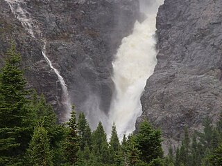
Rattling Brook is a local service district and designated place in the Canadian province of Newfoundland and Labrador. It is in the north-central portion of the island of Newfoundland near Baie Verte and Springdale. Formerly a fishing village, its main residents are retirees and seasonal tourists.
Colinet is an incorporated town located on the northwest arm of St. Mary's Bay in Newfoundland and Labrador, Canada.
Hawke's Bay is a town at the mouth of Torrent River southeast of Point Riche in the Canadian province of Newfoundland and Labrador.
Bellburns is a fishing settlement in the Canadian province of Newfoundland and Labrador. The town holds strong economic ties with the two closest towns Daniels Harbour and Portland Creek.
Bird Cove is a town in the Canadian province of Newfoundland and Labrador.
Brent's Cove is a town in the Canadian province of Newfoundland and Labrador.
Brighton is a town in the Canadian province of Newfoundland and Labrador.
Bryant's Cove is a town in the Canadian province of Newfoundland and Labrador.
Chance Cove is a town in the Canadian province of Newfoundland and Labrador. The town had a population of 213 in the Canada 2021 Census.
Long Harbour–Mount Arlington Heights is a town in the Canadian province of Newfoundland and Labrador. The town had a population of 185 in the Canada 2021 Census.
Main Brook is a town in the Canadian province of Newfoundland and Labrador. The town had a population of 246 in the Canada 2021 Census.
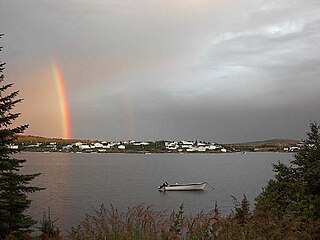
Mary's Harbour is a town in the Canadian province of Newfoundland and Labrador. The town had a population of 312 in the Canada 2021 Census, down from 341 in the Canada 2016 Census. It is serviced by Mary's Harbour Airport.
Point au Gaul is a town in the Canadian province of Newfoundland and Labrador, Canada. The town had a population of 67 in the Canada 2021 Census, down from 88 in 2016. Point au Gaul is approximately 76 km southeast of Marystown.
St. Mary's is a town in the Canadian province of Newfoundland and Labrador. The town had a population of 313 in the Canada 2021 Census.
West St. Modeste is a town in the Canadian province of Newfoundland and Labrador. The town had a population of 102 in the Canada 2021 Census.
Division No. 2, Newfoundland and Labrador is a census division in the Canadian province of Newfoundland and Labrador, primarily comprising the Burin Peninsula. Like all census divisions in Newfoundland and Labrador, but unlike the census divisions of some other provinces, the division exists only as a statistical division for census data, and is not a political entity.
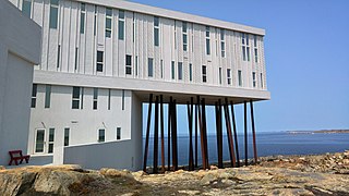
Fogo Island is a town located on Fogo Island, the largest of the offshore islands in the province of Newfoundland and Labrador, Canada.