
Grand Bank or 'Grand Banc' as the first French settlers pronounced it, is a small rural town in the Canadian province of Newfoundland and Labrador, with a population of 2,580. It is located on the southern tip or "toe" of the Burin Peninsula, 360 km from the province's capital of St. John's.
The Burin Peninsula is a peninsula located on the south coast of the island of Newfoundland in the province of Newfoundland and Labrador. Marystown is the largest population centre on the peninsula.
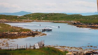
Virgin Arm–Carter's Cove is a local service district and designated place on New World Island in the Canadian province of Newfoundland and Labrador. Virgin Arm-Carter's Cove is located approximately 90 km Northwest of Gander in Subdivision H of Division No. 8.

Harbour Breton is a small fishing community on the Connaigre Peninsula in Fortune Bay, on the south coast of the island of Newfoundland in Canada. It is the largest center on the Connaigre Peninsula and was long considered the unofficial capital of Fortune Bay. During the 1960s many communities were resettled into Harbour Breton. Harbour Breton is the only administrative centre in Fortune Bay and is located approximately 200 kilometres (120 mi) south of Grand Falls-Windsor.
Musgrave Harbour is a town and designated place in the Canadian province of Newfoundland and Labrador.

English Harbour East is a town in the Canadian province of Newfoundland and Labrador. It is located on the northeast side of Fortune Bay. Settled first by the Mi’kmaq of Newfoundland which used land on the "Neck" of the Harbour, they were joined in the early 1800s, by the English Dodge family and by Irishman Thomas Hynes Sr. European fishermen were first brought to the small community by English merchant family of Newman and Co. based in Harbour Breton, the firm of merchant John Gorman, and the Jersey firm of Nicholle and Co. The town had a population of 117 in the Canada 2021 Census.

Humber Arm South is a town in the Canadian province of Newfoundland and Labrador. The town consists of the communities of Halfway Point, Benoit's Cove, John's Beach, and Frenchman's Cove. The town had a population of 1,537 in the Canada 2021 Census. The Town's Post Office is located in Benoit's Cove. Humber Arm South is located in the Bay of Islands and is in the Humber-Bay of Islands electoral district. The town's residents are of Mi'kmaw, Innu, and European descent.

St. Bernard's-Jacques Fontaine is a town in the Canadian province of Newfoundland and Labrador. The town had a population of 433 in the Canada 2021 Census, a drop from 470 in 2011.

St. Jacques-Coomb's Cove is a town in the Canadian province of Newfoundland and Labrador. The town had a population of 546 in the Canada 2021 Census. It is located on the south coast of the island of Newfoundland on the north side of Fortune Bay, on the southern tip of the Connaigre Peninsula in what is now known as the Coast of Bays Region. The town consists of six communities, St. Jacques, English Harbour West, Mose Ambrose, Boxey, Coomb's Cove, and Wreck Cove, all nestled within the inlets along the coast. They all had their beginnings in the fisheries and the fisheries have always been the mainstay of employment in the communities. In recent years aquaculture was introduced in the area, providing employment for its residents.
Ship Harbour is a community in Newfoundland and Labrador, Canada located on the eastern shore of Placentia Bay.
Fortune Harbour or Fortune Harbor is a designated place in the Canadian province of Newfoundland and Labrador.

Resettlement in Newfoundland and Labrador terms refers to an organized approach to centralize the population into growth areas. It is used in the current context when referring to a voluntary relocation initiated from isolated communities themselves.
Caplin Cove-Southport is a local service district and designated place in Trinity Bay in the Canadian province of Newfoundland and Labrador. Caplin Cove-Southport is approximately 50 km from Clarenville.
Iona was a small community in Placentia Bay, Newfoundland and Labrador made up of small islands that used to be inhabited. The islands were once called The Ram's or Ram's Islands.

Woods Island is an island in the Canadian province of Newfoundland and Labrador. It contains an abandoned town with the same name.
Pays Cove is an abandoned town in Newfoundland and Labrador, Canada that had a peak population of 11 in 1935.
Ryle's Barrisway is an abandoned town in Newfoundland and Labrador, Canada that had a small population which was first recorded in 1898.
Trammer is an abandoned town in Newfoundland and Labrador, Canada that had a peak population of 15 in 1901.
Jemmy's Cove is a tiny abandoned town located near New Harbour, Fortune Bay in Newfoundland and Labrador, Canada that had a peak population of 6 in 1911.
Cape Roger Harbour is a tiny abandoned town located near St. Joseph's, Placentia Bay in Newfoundland and Labrador, Canada that had a tiny population of 4 in 1845. Despite only being sparsely inhabited, the harbour has been used since the early 19th century for the fishery, particularly that of the herring and salmon fishery.
