Related Research Articles

Marystown is a town in the province of Newfoundland and Labrador, Canada, with a population of around 5,000. Situated 306 km from the province's capital, St. John's, it is on the Burin Peninsula. Until the early 1990s, its economy was largely based on shipbuilding, and it is due in part to this that the town experienced a population increase of 295% in just over a decade. The town was also dependent on the fish plant for employment.

Grand Bank or 'Grand Banc' as the first French settlers pronounced it, is a small rural town in the Canadian province of Newfoundland and Labrador, with a population of 2,580. It is located on the southern tip or "toe" of the Burin Peninsula, 360 km from the province's capital of St. John's.

Fortune Bay—Cape La Hune is a provincial electoral district for the House of Assembly of Newfoundland and Labrador, Canada. When created in 1975 it was called Fortune-Hermitage. As of 2011, there are 6,053 eligible voters living within the district.

Trepassey is a small fishing community located in Trepassey Bay on the south eastern corner of the Avalon Peninsula of Newfoundland and Labrador. It was in Trepassey Harbour where the flight of the Friendship took off, with Amelia Earhart on board, the first woman to fly across the Atlantic Ocean.
The Burin Peninsula is a peninsula located on the south coast of the island of Newfoundland in the province of Newfoundland and Labrador. Marystown is the largest population centre on the peninsula.

Belleoram is a village on the shores of Fortune Bay in the Canadian province of Newfoundland and Labrador.
Fortune Bay is a fairly large natural bay located in the Gulf of St. Lawrence on the south coast of Newfoundland, Canada. The Bay is bounded by Point Crewe on the Burin Peninsula and Pass Island at the entrance to Hermitage Bay to the northwest for a distance of 56 kilometers. The bay extends in a northeast direction for 105 kilometers ending at Terrenceville.

Harbour Breton is a small fishing community on the Connaigre Peninsula in Fortune Bay, on the south coast of the island of Newfoundland in Canada. It is the largest center on the Connaigre Peninsula and was long considered the unofficial capital of Fortune Bay. During the 1960s many communities were resettled into Harbour Breton. Harbour Breton is the only administrative centre in Fortune Bay and is located approximately 220 kilometres (140 mi) south of Grand Falls-Windsor.

Gaultois is a small settlement in the Coast of Bays area in Newfoundland and Labrador, Canada. Gaultois had a population of 100 people in the 2021 census. The town has a K-12 school called Victoria Academy, as well as a fire department, public library, Lion's Club, and town hall. The town is only accessible by ferry or helicopter. The provincial government ferry runs from the nearby town of Hermitage several times daily and the crossing takes approximately 20 minutes. This ferry also services the more remote community of McCallum once to twice daily with a crossing time of around one hour and fifteen minutes. In 2015, Gaultois voted against resettlement. Gaultois considered resettlement again in 2023 but it failed.

Rencontre East is a small, outport community in Newfoundland and Labrador, Canada located north east of Belleoram, and west of Terrenceville in Fortune Bay. The population was 115 in the 2021 census. This small community is not connected to any surrounding areas by road

Rose Blanche – Harbour le Cou is a small town on Newfoundland's southwest shore, about 45 km at the end of Route 470 from Port aux Basques. This community is located in a barren area on the east side of a small bay. In this bay there are 2 harbours that were mainly used to provide shelter for fishing vessels. Scenery includes the rugged granite coastline, and the white and rocky cliffs of "Diamond Cove". Its granite lighthouse was in operation from 1873 to the 1940s. After it was abandoned in the 1940s the building fell into ruins. The spiral stone staircase extends into the tower wall and kept the tower from collapsing while the remainder of the lighthouse fell to ruin. In 1999 the lighthouse was fully reconstructed and serves as a tourist attraction.
Hermitage-Sandyville is a small town on the south coast of Newfoundland, Canada, with a population of 404 people in the 2021 Census. The main source of income for the community is provided by the aquaculture industry, the local salmon plant and fishing.
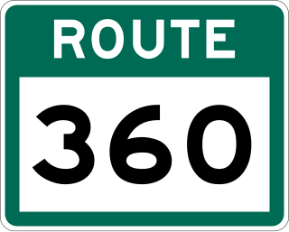
Route 360, also known as Bay d'Espoir Highway, is a provincial highway in Newfoundland and Labrador. It runs from the Bishop's Falls area to Bay d'Espoir and Harbour Breton. The road is very isolated for at least 140 kilometres (87 mi), where there are no communities or stops to refuel. Bishop's Falls and Harbour Breton are the only two settlements of any size along the entire length of Route 360, with other towns and communities being along the other highways it intersects.

English Harbour East is a town in the Canadian province of Newfoundland and Labrador. It is located on the northeast side of Fortune Bay. Settled first by the Mi’kmaq of Newfoundland which used land on the "Neck" of the Harbour, they were joined in the early 1800s, by the English Dodge family and by Irishman Thomas Hynes Sr. European fishermen were first brought to the small community by English merchant family of Newman and Co. based in Harbour Breton, the firm of merchant John Gorman, and the Jersey firm of Nicholle and Co. The town had a population of 117 in the Canada 2021 Census.

St. Bernard's-Jacques Fontaine is a town in the Canadian province of Newfoundland and Labrador. The town had a population of 433 in the Canada 2021 Census, a drop from 470 in 2011.

St. Jacques-Coomb's Cove is a town in the Canadian province of Newfoundland and Labrador. The town had a population of 546 in the Canada 2021 Census. It is located on the south coast of the island of Newfoundland on the north side of Fortune Bay, on the southern tip of the Connaigre Peninsula in what is now known as the Coast of Bays Region. The town consists of six communities, St. Jacques, English Harbour West, Mose Ambrose, Boxey, Coomb's Cove, and Wreck Cove, all nestled within the inlets along the coast. They all had their beginnings in the fisheries and the fisheries have always been the mainstay of employment in the communities. In recent years aquaculture was introduced in the area, providing employment for its residents.
Bay d'Espoir Academy is a K-12 school in St. Alban's, Newfoundland and Labrador, Canada that serves the Bay d'Espoir region of the south coast in Central Newfoundland. The principal is Connie Willcott and the vice-principal is Rebecca Parsons-Burden. The school operates under the Newfoundland and Labrador English School District.
The Connaigre Peninsula is a Canadian peninsula located on the south coast of the island of Newfoundland in the province of Newfoundland and Labrador. Harbour Breton is the largest population centre on the peninsula.

Route 212, also known as Bay L’Argent Road, is a 30.2-kilometre-long (18.8 mi) north–south highway on the Burin Peninsula of the island of Newfoundland in the Canadian province of Newfoundland and Labrador. It connects several communities along the northeastern corner of Fortune Bay with Route 210.
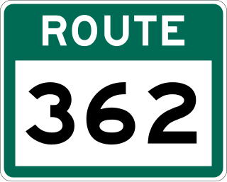
Route 362, also known as Belleoram Road, is a 35.5-kilometre-long (22.1 mi) north-south highway on the Connaigre Peninsula of the island of Newfoundland. It connects the communities along the western side of Fortune Bay with Route 360. Cell phone reception along Route 362 is severely limited.
References
- ↑ "Touring Newfoundland's Connaigre Peninsula". Cape Breton Post . Saltwire Network. November 17, 2016. Archived from the original on 7 July 2019. Retrieved October 21, 2019.
- ↑ Stoodley, Allan. "From fertilizer to delicacy: The history of lobster fishing in Fortune Bay". CBC News. Retrieved 25 November 2020.
- ↑ "St. Jacques Island Lighthouse". Parks Canada. Retrieved Nov 25, 2020.
- ↑ "Fitzgerald Academy". Newfoundland and Labrador English School District. Retrieved 25 November 2020.
- ↑ Hunt, Clayton. "Schools adjusting to lower enrolments | SaltWire". Saltwire.com. Retrieved 27 January 2022.