Harbour Breton

Last updated

Harbour Breton
Town
Harbour Breton NL 1.jpg
Canada Newfoundland location map.svg
Red pog.svg
Harbour Breton
Location of Harbour Breton in Newfoundland
Coordinates: 47°29′N55°50′W / 47.483°N 55.833°W / 47.483; -55.833
Country Flag of Canada (Pantone).svg  Canada
Province Flag of Newfoundland and Labrador.svg  Newfoundland and Labrador
Government
  MayorLloyd Blake
   MHA Elvis Loveless
Population
 (2021)
  Total1,477
  Density118.9/km2 (308/sq mi)
Time zone UTC-3:30 (Newfoundland Time)
  Summer (DST) UTC-2:30 (Newfoundland Daylight)
Area code 709
Highways NL Route 360.svg Route 360
Website www.harbourbreton.com

Harbour Breton is a small fishing community on the Connaigre Peninsula in Fortune Bay, on the south coast of the island of Newfoundland in Canada. It is the largest center on the Connaigre Peninsula and was long considered the unofficial capital of Fortune Bay. [1] During the 1960s many communities were resettled into Harbour Breton. Harbour Breton is the only administrative centre in Fortune Bay and is located approximately 220 kilometres (140 mi) south of Grand Falls-Windsor. [2] [3]

Contents

History

Harbour Breton is known for its rich fishing history. However, the first major company to take up post here was Newman & Co. Based in England and famous for its port wine, this company happened upon the value of the town's marine climate in its wine aging process.

The Newman Company's ship Retriever arrived in Harbour Breton with a cargo of port wine around 1892. Through the 19th century, the company relied heavily on the importing of fishing servants from England and Ireland.

By 1871, the Newman & Co. employed about 100 people in salting, drying, packing, and shipping fish to Europe, Brazil and the West Indies. [4]

By the late 1800s, a large part of the population had either settled in Harbour Breton permanently, moved to other areas on the south coast which were connected with the Newman & Co. or returned to their country of origin. By 1891, Harbour Breton's population had reached 484. Of them, 443 were Newfoundland born with the remainder from England, Ireland, Scotland and other British colonies. Newman & Co. fortunes declined in the early 1900s and the company closed its operation in 1907.

A cottage hospital was built in Harbour Breton in 1936. Harbour Breton was designated as a growth centre in 1965 and the government encouraged people living in isolated communities to relocate to the town. From 1965 to 1971, a total of 700 people had moved to Harbour Breton. Many residents resettled from Sagona Island, [5] Jersey Harbour, Little Bay West, Miller's Passage, Red Cove, and Grole. In 1971, Harbour Breton was linked to Trans Canada Highway by road. [6]

In 1973, a landslide on south side of Harbour Breton, killed 4 children from the Hickey family. [7] A monument was erected on the site of the Hickey house in 1997. [8] [9]

Harbour Breton has a notable fishing history, including companies such as Fishery Products International (FPI), which removed itself from the town in April 2005. [10] The Barry Group of Companies Inc. renovated the plant used by FPI and re-opened its doors in December 2006. [11] [12] [13] Cooke Aquaculture started a salmon processing operation in Harbour Breton at the Barry Group of Companies plant in 2008. The plant employed about 150 people, but it closed on January 31, 2014 when the Barry Group didn't renew its lease with Cooke Aquaculture. [14] [15] [16] [17] [18] Barry Group Inc. opened a fish meal plant in Harbour Breton in 2017. [19] [20] [21] [22]

Climate

Climate data for Harbour Breton
MonthJanFebMarAprMayJunJulAugSepOctNovDecYear
Record high °C (°F)12.5
(54.5)
11.0
(51.8)
16.0
(60.8)
17.0
(62.6)
20.5
(68.9)
25.5
(77.9)
26.0
(78.8)
27.5
(81.5)
26.5
(79.7)
22.0
(71.6)
17.0
(62.6)
12.0
(53.6)
27.5
(81.5)
Mean daily maximum °C (°F)−0.5
(31.1)
−0.8
(30.6)
1.3
(34.3)
5.5
(41.9)
10.0
(50.0)
13.4
(56.1)
17.0
(62.6)
18.7
(65.7)
15.9
(60.6)
11.1
(52.0)
6.5
(43.7)
2.4
(36.3)
8.4
(47.1)
Daily mean °C (°F)−4.1
(24.6)
−4.3
(24.3)
−2.0
(28.4)
2.4
(36.3)
6.5
(43.7)
10.1
(50.2)
14.1
(57.4)
15.9
(60.6)
13.0
(55.4)
8.2
(46.8)
3.6
(38.5)
−0.8
(30.6)
5.2
(41.4)
Mean daily minimum °C (°F)−7.6
(18.3)
−7.8
(18.0)
−5.3
(22.5)
−0.6
(30.9)
3.0
(37.4)
6.8
(44.2)
11.2
(52.2)
13.1
(55.6)
9.9
(49.8)
5.4
(41.7)
0.7
(33.3)
−3.9
(25.0)
2.1
(35.8)
Record low °C (°F)−19.0
(−2.2)
−24.0
(−11.2)
−23.0
(−9.4)
−14.0
(6.8)
−6.0
(21.2)
−0.5
(31.1)
2.5
(36.5)
4.5
(40.1)
−1.0
(30.2)
−5.5
(22.1)
−12.0
(10.4)
−18.0
(−0.4)
−24.0
(−11.2)
Average precipitation mm (inches)111.7
(4.40)
120.2
(4.73)
102.2
(4.02)
125.3
(4.93)
117.4
(4.62)
138.3
(5.44)
119.1
(4.69)
93.0
(3.66)
139.5
(5.49)
147.2
(5.80)
149.8
(5.90)
121.5
(4.78)
1,485.1
(58.47)
Average rainfall mm (inches)63.2
(2.49)
83.1
(3.27)
77.3
(3.04)
117.7
(4.63)
116.2
(4.57)
138.3
(5.44)
119.1
(4.69)
93.0
(3.66)
139.5
(5.49)
147.1
(5.79)
143.3
(5.64)
86.7
(3.41)
1,324.4
(52.14)
Average snowfall cm (inches)48.5
(19.1)
37.1
(14.6)
24.9
(9.8)
7.6
(3.0)
1.2
(0.5)
0.0
(0.0)
0.0
(0.0)
0.0
(0.0)
0.0
(0.0)
0.1
(0.0)
6.5
(2.6)
34.8
(13.7)
160.7
(63.3)
Source: Environment Canada [23]

Demographics

In the 2021 Census of Population conducted by Statistics Canada, Harbour Breton had a population of 1,477 living in 632 of its 699 total private dwellings, a change of

See also

Related Research Articles

<span class="mw-page-title-main">Marystown</span> Town in Newfoundland and Labrador, Canada

Marystown is a town in the province of Newfoundland and Labrador, Canada, with a population of around 5,000. Situated 306 km from the province's capital, St. John's, it is on the Burin Peninsula. Until the early 1990s, its economy was largely based on shipbuilding, and it is due in part to this that the town experienced a population increase of 295% in just over a decade. The town was also dependent on the fish plant for employment.

<span class="mw-page-title-main">Fortune Bay-Cape La Hune</span> Provincial electoral district in Newfoundland and Labrador, Canada

Fortune Bay—Cape La Hune is a provincial electoral district for the House of Assembly of Newfoundland and Labrador, Canada. When created in 1975 it was called Fortune-Hermitage. As of 2011, there are 6,053 eligible voters living within the district.

Ramea is a small village in Newfoundland and Labrador located on Northwest Island, one of a group of five major islands located off the south coast of Newfoundland, Canada. The island is approximately 3.14 km long by 0.93 km wide. The other major islands in the archipelago are Great Island, Middle Island, Harbour Island, and South West Island.

The Burin Peninsula is a peninsula located on the south coast of the island of Newfoundland in the province of Newfoundland and Labrador. Marystown is the largest population centre on the peninsula.

<span class="mw-page-title-main">McCallum, Newfoundland and Labrador</span> Local service district / designated place in Newfoundland and Labrador, Canada

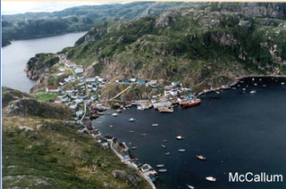
McCallum is a local service district and designated place in the Canadian province of Newfoundland and Labrador. McCallum is located on the southern coast of the island of Newfoundland. It is accessible only by boat or by air, and in appearance and way of life is thought by some to be as close to a pre-20th century community as may be found. McCallum lies in an enclosed harbour and is sheltered between two hills. The community survives primarily on the fishery. Whaling was also a major industry in the late 19th century. The provincial government runs a ferry service to McCallum from the nearby town of Hermitage, about an hour and a half away by boat, where the nearest road is located.

<span class="mw-page-title-main">Belleoram</span> Town in Newfoundland and Labrador, Canada

Belleoram is a village on the shores of Fortune Bay in the Canadian province of Newfoundland and Labrador.

<span class="mw-page-title-main">Makkovik</span> Town in Newfoundland and Labrador, Canada

Makkovik is a town in Labrador in eastern Canada. It had 365 residents in 2021. The main industry is snow crabbing and there is a fishing cooperative.

<span class="mw-page-title-main">Burin, Newfoundland and Labrador</span> Town in Newfoundland and Labrador, Canada

Burin is a town on the Burin Peninsula in Placentia Bay, Newfoundland and Labrador, Canada. The Burin Peninsula is often affectionately nicknamed "The Boot" due to its resemblance to the footwear when seen on a map, with the town of Burin located near the "heel". Burin is approximately 318 km from the capital of St. John's. Settlement in Burin dates to the early 18th century, although documentary evidence indicates that French fishermen had been fishing and exploring the area even earlier.

<span class="mw-page-title-main">St. Alban's, Newfoundland and Labrador</span> Town in Newfoundland and Labrador, Canada

St. Alban's is a town of approximately 1,200 located in the Bay d'Espoir estuary on the south coast of Newfoundland, Canada. St. Alban's is the largest community in Bay d'Espoir. The town is 180 kilometres (110 mi) south of Grand Falls-Windsor.

<span class="mw-page-title-main">Gaultois</span> Town in Newfoundland and Labrador, Canada

Gaultois is a small settlement in the Coast of Bays area in Newfoundland and Labrador, Canada. Gaultois had a population of 100 people in the 2021 census. The town has a K-12 school called Victoria Academy, as well as a fire department, public library, Lion's Club, and town hall. The town is only accessible by ferry or helicopter. The provincial government ferry runs from the nearby town of Hermitage several times daily and the crossing takes approximately 20 minutes. This ferry also services the more remote community of McCallum once to twice daily with a crossing time of around one hour and fifteen minutes. In 2015, Gaultois voted against resettlement. Gaultois considered resettlement again in 2023 but it failed.

<span class="mw-page-title-main">Rencontre East</span> Town in Newfoundland and Labrador, Canada

Rencontre East is a small, outport community in Newfoundland and Labrador, Canada located north east of Belleoram, and west of Terrenceville in Fortune Bay. The population was 115 in the 2021 census. This small community is not connected to any surrounding areas by road

<span class="mw-page-title-main">Rose Blanche-Harbour le Cou</span> Town in Newfoundland and Labrador, Canada

Rose Blanche – Harbour le Cou is a small town on Newfoundland's southwest shore, about 45 km at the end of Route 470 from Port aux Basques. This community is located in a barren area on the east side of a small bay. In this bay there are 2 harbours that were mainly used to provide shelter for fishing vessels. Scenery includes the rugged granite coastline, and the white and rocky cliffs of "Diamond Cove". Its granite lighthouse was in operation from 1873 to the 1940s. After it was abandoned in the 1940s the building fell into ruins. The spiral stone staircase extends into the tower wall and kept the tower from collapsing while the remainder of the lighthouse fell to ruin. In 1999 the lighthouse was fully reconstructed and serves as a tourist attraction.

Hermitage-Sandyville is a small town on the south coast of Newfoundland, Canada, with a population of 404 people in the 2021 Census. The main source of income for the community is provided by the aquaculture industry, the local salmon plant and fishing.

<span class="mw-page-title-main">Pool's Cove</span> Town in Newfoundland and Labrador, Canada

Pool's Cove is a community located on the north west side of Fortune Bay, on the South Coast of Newfoundland, Canada. The town had a population of 143 in the 2021 Census.

Bay L'Argent is a town in the Canadian province of Newfoundland and Labrador.

<span class="mw-page-title-main">Salvage, Newfoundland and Labrador</span> Town in Newfoundland and Labrador, Canada

Salvage is a town located on the Eastport Peninsula of the Canadian province of Newfoundland and Labrador. The town had a population of 108 in the Canada 2021 Census.

<span class="mw-page-title-main">St. Jacques-Coomb's Cove</span> Town in Newfoundland and Labrador, Canada

St. Jacques-Coomb's Cove is a town in the Canadian province of Newfoundland and Labrador. The town had a population of 546 in the Canada 2021 Census. It is located on the south coast of the island of Newfoundland on the north side of Fortune Bay, on the southern tip of the Connaigre Peninsula in what is now known as the Coast of Bays Region. The town consists of six communities, St. Jacques, English Harbour West, Mose Ambrose, Boxey, Coomb's Cove, and Wreck Cove, all nestled within the inlets along the coast. They all had their beginnings in the fisheries and the fisheries have always been the mainstay of employment in the communities. In recent years aquaculture was introduced in the area, providing employment for its residents.

The Connaigre Peninsula is a Canadian peninsula located on the south coast of the island of Newfoundland in the province of Newfoundland and Labrador. Harbour Breton is the largest population centre on the peninsula.

English Harbour West is a village located on the south west shore of Fortune Bay. It is noted for its bank fishing and inshore fishing. The Way Office was established in 1866 on April 1. The first Way Master was Albert Stirling. In 1891 it became a Post Office town and William Evans was the first Postmaster.

<span class="mw-page-title-main">Newfoundland and Labrador Route 212</span> Highway in Newfoundland and Labrador

Route 212, also known as Bay L’Argent Road, is a 30.2-kilometre-long (18.8 mi) north–south highway on the Burin Peninsula of the island of Newfoundland in the Canadian province of Newfoundland and Labrador. It connects several communities along the northeastern corner of Fortune Bay with Route 210.

References

  1. "Touring Newfoundland's Connaigre Peninsula". Cape Breton Post . Saltwire Network. November 17, 2016. Archived from the original on 7 July 2019. Retrieved October 21, 2019.
  2. "Thousands of people in a huge stretch of southern Newfoundland are losing their last doctor". CBC News. April 6, 2022. Retrieved April 6, 2022.
  3. "Hundreds protest ER closures in Harbour Breton, health minister promises recruitment priority". CBC News. May 9, 2023. Retrieved May 13, 2023.
  4. Kraig Anderson. "Rocky Point (Harbour Breton) Lighthouse". Lighthousefriends.com. Retrieved August 19, 2022. We were struck with the neat and cheerful look of the place, and the signs of prosperity and order that the buildings etc., showed. On landing our first impressions were fully justified .... This place, the headquarters in Newfoundland of Messrs. Newman & Hunt, at present employs (exclusive of fishermen) about 100 people in salting, drying, pickling, packing and shipping fish to Europe, Brazil and the West Indies, and is managed by Mr. Gallop, on whom its order and cleanliness reflects great credit .... Messrs. Newman & Hunt's establishment is very complete, besides stores for receiving, sorting and packing the fish, they have carpenters, coopers and blacksmiths' shops, and have also built several nice schooners; they keep large wholesale and retail stores where everything required by the country people can be obtained; they are now building a large store for coals capable of holding about 500 tons.
  5. "Sagona Island". Maritime History Archive, Memorial University. Retrieved Oct 16, 2020.
  6. "The road to Bay d'Espoir". Cape Breton Post. 4 Aug 2016. Retrieved 14 Aug 2022.
  7. "A life of loss, grief". The Telegram (St. John's). July 12, 2008. Retrieved Oct 16, 2020.
  8. Government of Newfoundland and Labrador (August 19, 2020). "Landslides". Department of Industry, Energy and Technology. Retrieved August 19, 2022. On August 1, 1973, following several weeks of heavy rainfall, a debris torrent occurred at about 3 a.m. in a gully above the community, resulting in the deaths of four children. Four houses were swept into the harbour and destroyed. Further slope movements continued over the days following the disaster. Pauline, Edward, Timothy and Julia Hickey, aged 8, 7, 5, and 4, all from the family of Jack and Olive Hickey, were killed. There were 14 survivors. The youngest Hickey child Cavell, who was 21 months old at the time, was trapped when the water and mud forced her crib into the attic of the house. Rescuers heard her cries and reached her by cutting a hole in the roof. 53 year old Beatrice Hunt was trapped beneath her cast iron stove for 6 hours before rescue but survived with only minor cuts and bruises. Following the disaster 14 other homes were relocated, and a ban on development in the landslide area was implemented. A monument was erected on the site of the Hickey house in 1997.
  9. Town of Harbour Breton (July 22, 2009). "Harbour Breton Landslide Monument Municipal Heritage Site". Canadian Register of Historic Places. Retrieved August 19, 2022. Located on South Side Drive, Harbour Breton, NL, Harbour Breton Landslide Monument is a landscaped site that includes a granite monument, granite benches and a large boulder with an attached explanatory plaque. The designation is confined to that piece of land known locally as Harbour Breton Landslide Monument.
  10. "Barry picks up Harbour Breton plant for $1". CBC News. Sep 15, 2006. Retrieved Oct 16, 2020.
  11. "Barry Group to operate Harbour Breton plant". CBC News. Feb 7, 2006. Retrieved Oct 16, 2020.
  12. "Company, town reach agreement in principle to operate Harbour Breton plant". Government of Newfoundland and Labrador. Feb 7, 2006. Retrieved Oct 16, 2020.
  13. "Tremendous Day For Harbour Breton". Government of Newfoundland and Labrador. Dec 13, 2006. Retrieved Oct 16, 2020.
  14. "Harbour Breton salmon plant won't reopen". CBC News. Jan 14, 2014. Retrieved Oct 16, 2020.
  15. "Harbour Breton plant should be operating later this year: Bill Barry". CBC News. Feb 18, 2015. Retrieved Oct 16, 2020.
  16. "Tired of waiting for the plant to reopen". Saltwire Network. Sep 29, 2017. Retrieved Oct 16, 2020.
  17. "Harbour Breton fish plant workers face uncertainty". CBC News. Jan 15, 2014. Retrieved Oct 16, 2020.
  18. "CFIA orders ISA infected salmon destroyed". CBC News. Nov 8, 2013. Retrieved Oct 16, 2020.
  19. "Harbour Breton fish meal plant given environmental green light". Saltwire Network. Jun 15, 2017. Retrieved Oct 16, 2020.
  20. "N.L. government dismisses environmental appeal of Harbour Breton fish meal plant". The Telegram. Oct 4, 2017. Retrieved Oct 16, 2020.
  21. "Harbour Breton Fish Meal Plant - Summary of Environmental Assessment Process". Government of Newfoundland and Labrador: Environment, Climate Change and Municipalities. Retrieved Oct 16, 2020.
  22. "St. Alban's fish plant expected to remain closed". CBC News. Aug 16, 2018. Retrieved Oct 16, 2020.
  23. "Harbour Breton". Canadian Climate Normals 1981–2010 (in English and French). Environment Canada. 31 October 2011. Retrieved September 1, 2015.
  24. "Population and dwelling counts: Canada, provinces and territories, census divisions and census subdivisions (municipalities), Newfoundland and Labrador". Statistics Canada. February 9, 2022. Retrieved March 15, 2022.

47°29′N55°50′W / 47.483°N 55.833°W / 47.483; -55.833