
Fortune Bay—Cape La Hune is a provincial electoral district for the House of Assembly of Newfoundland and Labrador, Canada. When created in 1975 it was called Fortune-Hermitage. As of 2011, there are 6,053 eligible voters living within the district.
The Burin Peninsula is a peninsula located on the south coast of the island of Newfoundland in the province of Newfoundland and Labrador. Marystown is the largest population centre on the peninsula.
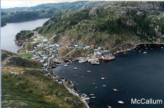
McCallum is a local service district and designated place in the Canadian province of Newfoundland and Labrador. McCallum is located on the southern coast of the island of Newfoundland. It is accessible only by boat or by air, and in appearance and way of life is thought by some to be as close to a pre-20th century community as may be found. McCallum lies in an enclosed harbour and is sheltered between two hills. The community survives primarily on the fishery. Whaling was also a major industry in the late 19th century. The provincial government runs a ferry service to McCallum from the nearby town of Hermitage, about an hour and a half away by boat, where the nearest road is located.
Fortune Bay is a fairly large natural bay located in the Gulf of St. Lawrence on the south coast of Newfoundland, Canada. The Bay is bounded by Point Crewe on the Burin Peninsula and Pass Island at the entrance to Hermitage Bay to the northwest for a distance of 56 kilometers. The bay extends in a northeast direction for 105 kilometers ending at Terrenceville.

Harbour Breton is a small fishing community on the Connaigre Peninsula in Fortune Bay, on the south coast of the island of Newfoundland in Canada. It is the largest center on the Connaigre Peninsula and was long considered the unofficial capital of Fortune Bay. During the 1960s many communities were resettled into Harbour Breton. Harbour Breton is the only administrative centre in Fortune Bay and is located approximately 220 kilometres (140 mi) south of Grand Falls-Windsor.

Gaultois is a small settlement in the Coast of Bays area in Newfoundland and Labrador, Canada. Gaultois had a population of 100 people in the 2021 census. The town has a K-12 school called Victoria Academy, as well as a fire department, public library, Lion's Club, and town hall. The town is only accessible by ferry or helicopter. The provincial government ferry runs from the nearby town of Hermitage several times daily and the crossing takes approximately 20 minutes. This ferry also services the more remote community of McCallum once to twice daily with a crossing time of around one hour and fifteen minutes. In 2015, Gaultois voted against resettlement. Gaultois considered resettlement again in 2023 but it failed.

Rencontre East is a small, outport community in Newfoundland and Labrador, Canada located north east of Belleoram, and west of Terrenceville in Fortune Bay. The population was 115 in the 2021 census. This small community is not connected to any surrounding areas by road but is accessible by scheduled ferry service from ports in Pool's Cove and Bay L'Argent.
Nova Central School District was a school district headquartered in Gander in the Canadian province of Newfoundland and Labrador. The district had 66 schools located in 50 different communities, and served about 13,000 students, including a significant rural population. The District was formed by the merger of the Lewisporte-Gander and Baie Verte-Central-Connaigre school boards in 2004. The largest school in the district was Gander Academy. The district was replaced by the Newfoundland and Labrador English School District upon provincial amalgamation in 2013.
Hermitage-Sandyville is a small town on the south coast of Newfoundland, Canada, with a population of 404 people in the 2021 Census. The main source of income for the community is provided by the aquaculture industry, the local salmon plant and fishing.

Pool's Cove is a community located on the north west side of Fortune Bay, on the South Coast of Newfoundland, Canada. The town had a population of 143 in the 2021 Census.
Route 210, also known as the Burin Peninsula Highway and Heritage Run, is a highway that extends through the Burin Peninsula from Goobies to Grand Bank, Newfoundland and Labrador. The maximum speed limit is 90 km/h except through communities and settlements where the speed limit is reduced to 50 km/h. Just after exiting Swift Current, until a few kilometres north of Marystown, much of the landscape is barren, with very few trees prevalent. After entering Marystown, motorists approach a junction where they could turn right to continue their journey on Route 210 until arriving at Grand Bank, or going straight onto Route 220 towards Burin and St. Lawrence. Marystown is the most populous community along the route.
Route 360, also known as Bay d'Espoir Highway, is a provincial highway in Newfoundland and Labrador. It runs from the Bishop's Falls area to Bay d'Espoir and Harbour Breton. The road is very isolated for at least 140 kilometres (87 mi), where there are no communities or stops to refuel. Bishop's Falls and Harbour Breton are the only two settlements of any size along the entire length of Route 360, with other towns and communities being along the other highways it intersects.
Bay L'Argent is a town in the Canadian province of Newfoundland and Labrador.

St. Jacques-Coomb's Cove is a town in the Canadian province of Newfoundland and Labrador. The town had a population of 546 in the Canada 2021 Census. It is located on the south coast of the island of Newfoundland on the north side of Fortune Bay, on the southern tip of the Connaigre Peninsula in what is now known as the Coast of Bays Region. The town consists of six communities, St. Jacques, English Harbour West, Mose Ambrose, Boxey, Coomb's Cove, and Wreck Cove, all nestled within the inlets along the coast. They all had their beginnings in the fisheries and the fisheries have always been the mainstay of employment in the communities. In recent years aquaculture was introduced in the area, providing employment for its residents.

English Harbour West is a village located on the south west shore of Fortune Bay. It is noted for its bank fishing and inshore fishing. The Way Office was established in 1866 on April 1. The first Way Master was Albert Stirling. In 1891 it became a Post Office town and William Evans was the first Postmaster.
Hermitage Bay is an expansive bay stretching out along the south coast of Newfoundland. It is a body of Gulf of St. Lawrence which is near the Connaigre Peninsula. On its south, it is bordered by the Hermitage peninsula and the communities of Seal Cove, Hermitage and Sandyville. On its north side it is flanked by the communities of McCallum on mainland Newfoundland and by Gaultois on Long Island. Long Island separates Hermitage Bay from Bay d'Espoir farther inland to the north.
Division No. 3, Newfoundland and Labrador is a census division in the Canadian province of Newfoundland and Labrador, primarily comprising the South Coast of the island of Newfoundland, starting roughly 10km northwest of Channel-Port aux Basques and ending roughly 10km east of Rencontre East. Like all census divisions in Newfoundland and Labrador, but unlike the census divisions of some other provinces, the division exists only as a statistical division for census data, and is not a political entity.

Route 212, also known as Bay L’Argent Road, is a 30.2-kilometre-long (18.8 mi) north–south highway on the Burin Peninsula of the island of Newfoundland in the Canadian province of Newfoundland and Labrador. It connects several communities along the northeastern corner of Fortune Bay with Route 210.
Route 362, also known as Belleoram Road, is a 35.5-kilometre-long (22.1 mi) north-south highway on the Connaigre Peninsula of the island of Newfoundland. It connects the communities along the western side of Fortune Bay with Route 360. Cell phone reception along Route 362 is severely limited.
Route 364, also known as Hermitage River Road, is a 37.4-kilometre-long (23.2 mi) north–south highway on the Connaigre Peninsula of the island of Newfoundland. It connects the towns of Seal Cove and Hermitage-Sandyville with Route 360.
