People | Miꞌkmaq |
---|---|
Headquarters | Samiajij Miawpukek |
Province | Newfoundland and Labrador |
Land [1] | |
Reserve(s) | |
Land area | 28.39 km2 |
Population (2023) [1] | |
On reserve | 836 |
On other land | 2 |
Off reserve | 2263 |
Total population | 3101 |
Government [1] | |
Chief | Brad Benoit |
Council |
|
Website | |
mfngov.ca |
Samiajij Miawpukek | |
---|---|
Samiajij Miawpukek Indian Reserve | |
Coordinates: 47°52′0″N55°44′37″W / 47.86667°N 55.74361°W | |
Country | Canada |
Province | Newfoundland and Labrador |
Settled | 1822 [2] |
Recognition under the Indian Act | 1987 [2] |
Government | |
• Chief | Mi'sel Joel [3] |
• Federal MP | Clifford Small (CPC) |
• Provincial MHA | Elvis Loveless (LIB) |
Population (2023) | |
• Total | 836 |
Time zone | UTC-3:30 (Newfoundland Time Zone) |
Area code | 709 |
GNBC Code | ACPWX [4] |
Highways | Route 365 |
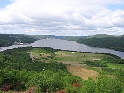
Miawpukek First Nation is a Mi'kmaq First Nations band government in Conne River, Newfoundland and Labrador, Canada, with a registered population of 836 living on-reserve as of May 2023, with another 2,265 living off-reserve. [5] [6] They control the reserve of Samiajij Miawpukek in Bay d'Espoir on the island of Newfoundland. It was formerly known as Conne River Indian Reserve until the mid-1980s. [7] Samiajij Miawpukek was established as a federal Indian reserve in 1987, the first in Newfoundland and Labrador. In 1991, Miawpukek was one of the poorest communities in Atlantic Canada. Due in part to increased education of its members, it has gone on to become the most well-off First Nation in Atlantic Canada after Membertou. [8] [9]
The powwow, started in 1996, is held every year. [10]
In 2019, the Miawpukek First Nation opened the "Cannabis Boutique", which they claim is "the first Indigenous-owned and -operated marijuana store in Newfoundland". [11]
Labrador is a geographic and cultural region within the Canadian province of Newfoundland and Labrador. It is the primarily continental portion of the province and constitutes 71% of the province's area but is home to only 6% of its population. It is separated from the island of Newfoundland by the Strait of Belle Isle. It is the largest and northernmost geographical region in the four Atlantic provinces.
The Naskapi are an Indigenous people of the Subarctic native to the historical country St'aschinuw, which is located in northern Quebec and Labrador, neighbouring Nunavik. They are closely related to Innu Nation, who call their homeland Nitassinan.
The Mi'kmaq are a First Nations people of the Northeastern Woodlands, indigenous to the areas of Canada's Atlantic Provinces, primarily Nova Scotia, New Brunswick, and Newfoundland, and the Gaspé Peninsula of Quebec as well as Native Americans in the northeastern region of Maine. The traditional national territory of the Mi'kmaq is named Miꞌkmaꞌki.
Nain is the northernmost permanent settlement in the Canadian province of Newfoundland and Labrador, within the Nunatsiavut region, located about 370 km (230 mi) by air from Happy Valley-Goose Bay. The town was established as a Moravian mission in 1771 by Jens Haven and other missionaries. As of 2021, the population is 1,204 mostly Inuit and mixed Inuit-European. Nain is the administrative capital of the autonomous region of Nunatsiavut.
Demasduit was a Beothuk woman, one of the last of her people on Newfoundland.
Torngat Mountains is a provincial electoral district for the House of Assembly of Newfoundland and Labrador, Canada. As of 2011 there are 2,130 eligible voters living within the district. The district takes its name from the Torngat Mountains.
Fortune Bay—Cape La Hune is a provincial electoral district for the House of Assembly of Newfoundland and Labrador, Canada. When created in 1975 it was called Fortune-Hermitage. As of 2011, there are 6,053 eligible voters living within the district.
The Mushuau Innu First Nation is a First Nations band government located in the province of Newfoundland and Labrador, Canada. The band has one reserve which has been located near the community of Natuashish since 2002 when it moved from Davis Inlet. The reserve has an area of roughly 44 square kilometres.
Beothuk Lake, formerly Red Indian Lake, is located in the interior of central Newfoundland in the province of Newfoundland and Labrador, Canada. The lake drains into the Exploits River which flows through the interior of Newfoundland and exits into the Atlantic Ocean through the Bay of Exploits. Lloyds River, the Victoria River and Star River feed into the lake.
Nonosabasut was a leader of the Beothuk people. Family head and partner of Demasduit, born on the island of Newfoundland. Sometimes referred to as Chief Nonosabasut, his stature within the last remaining Beothuk would better be described as that of a headman or leader.
Sheshatshiu is an Innu federal reserve and designated place in the Canadian province of Newfoundland and Labrador. The reserve is approximately 40 kilometres (25 mi) north of Happy Valley-Goose Bay. Some references may spell the community's name as Sheshatshit, the t spelling is more traditional in the Innu-aimun language, but the u is used more commonly in English to avoid inappropriate connotations. The name means "a narrow place in the river".
St. George's is a Canadian community in the St. George's Bay on the southwest coast of Newfoundland of the province of Newfoundland and Labrador.
St. Alban's is a town of approximately 1,200 located in the Bay d'Espoir estuary on the south coast of Newfoundland, Canada. St. Alban's is the largest community in Bay d'Espoir. The town is 180 kilometres (110 mi) south of Grand Falls-Windsor.
Noel Joseph JeddoreWe’jitu also Newell Jeddore Gietol, Geodol was Saqamaw "grand chief" of the Mi'kmaq at Miawpukek in Bay d'Espoir on the south coast of Newfoundland in the Coast of Islands region. Jeddore served as chief from July 26, 1919 until he was forced into exile to Eskasoni, Nova Scotia, in 1924. He was born at Indian Point, Bay d'Espoir and he died at Eskasoni, Cape Breton.
Bay d'Espoir is an arm of Hermitage Bay in the Gulf of Saint Lawrence, located on the south coast of Newfoundland. Communities in Bay d'Espoir include: Milltown-Head of Bay d'Espoir, Morrisville, St. Alban's, St. Joseph's Cove, St. Veronica's and Miawpukek. The Miawpukek First Nation reserve of Samiajij Miawpukek is located in Bay d'Espoir.
Natuashish is an Innu community in the Canadian province of Newfoundland and Labrador. The community is inhabited by the Mushuau Innu First Nation. Natuashish became a federal Indian reserve in 2003.
The Sheshatshiu Innu First Nation is located in the province of Newfoundland and Labrador, Canada. This First Nations band government is centred on the community of Sheshatshiu.
The Qalipu First Nation, is a Mi’kmaq band government, created by order-in-council in 2011 pursuant to the Agreement for the Recognition of the Qalipu Mi’kmaq Band. After the band was approved as a First Nation, 100,000 people applied for membership and a total of 23,000 were approved.
Route 365, also known as Conne River Road, is a 17.5-kilometre-long (10.9 mi) north–south highway on the island of Newfoundland in the Canadian province of Newfoundland and Labrador. It serves as the only road connection to the town of Conne River and the Miawpukek First Nation, connecting them with Route 360. It is a two-lane highway for its entire length and parallels the Conne River, the actual river, for the majority of its length, when its not following the banks of Bay d'Espoir.
The Friends of Qalipu Advocacy Association, is a non-profit Newfoundland and Labrador Mi’kmaq group that are representing rejected applicants to the Qalipu Mi'kmaq First Nation.