
Miramichi ( ) is the largest city in northern New Brunswick, Canada. It is situated at the mouth of the Miramichi River where it enters Miramichi Bay. The Miramichi Valley is the second longest valley in New Brunswick, after the Saint John River Valley.

Northumberland County is located in northeastern New Brunswick, Canada.
The Wolastoqiyik, also Wəlastəkwewiyik, Malecite or Maliseet are an Algonquian-speaking First Nation of the Wabanaki Confederacy. They are the Indigenous people of the Wolastoq valley and its tributaries. Their territory extends across the current borders of New Brunswick and Quebec in Canada, and parts of Maine in the United States.
Esgenoôpetitj is a Mi'kmaq Indian reserve in Northumberland County, New Brunswick, Canada. Prior to July 11, 2012, the Indian reserve was named Burnt Church 14.

The Southwest Miramichi River is a river in New Brunswick, Canada.
William Davidson was a Scottish-Canadian lumber merchant, shipbuilder and politician. He was the first permanent European settler on the Miramichi River in New Brunswick.
A tribal council is an association of First Nations bands in Canada, generally along regional, ethnic or linguistic lines.
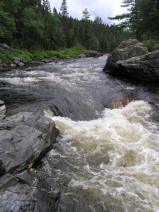
The Little Southwest Miramichi River is a river in Northumberland County, New Brunswick, Canada. In Mi'kmaq it is referred to as "Tooadook".
The Miramichi Valley is a Canadian river valley and region in the east-central part of New Brunswick. It extends along both major branches of the Miramichi River and their tributaries, however it is generally agreed that the much larger Southwest Miramichi River forms the majority of this region as it is more settled than the Northwest Miramichi River.
The Burnt Church Crisis was a conflict in Canada between the Mi'kmaq people of the Burnt Church First Nations (Esgenoôpetitj) and non-Aboriginal fisheries in New Brunswick and Nova Scotia between 1999 and 2002.
Metepenagiag, also known as Red Bank is a Mi'kmaq First Nation band government in New Brunswick, Canada on the other side of the Miramichi river from Sunny Corner.

The history of New Brunswick covers the period from the arrival of the Paleo-Indians thousands of years ago to the present day. Prior to European colonization, the lands encompassing present-day New Brunswick were inhabited for millennia by the several First Nations groups, most notably the Maliseet, Mi'kmaq, and the Passamaquoddy.

Gesgapegiag is one of two First Nations reserves on the south shore of the Gaspésie, most of whom are of Mi'kmaq ancestry. Most of the members reside on the federal Indian reserve that was set aside by the legislature of Lower Canada in 1853, for the exclusive use of the majority of Mi'kmaq in this region. The remaining Mi'kmaq live off-reserve in the eastern United States and across Canada, but stay connected to the community through modern communications and travel. All community members, regardless of residence, participate in democratic elections held every two years to elect one chief and eight councillors in accordance with Canada's Indian Act Election Regulations. The community is also allied to other Mi'kmaq communities in the Gaspé region of Quebec and in northern New Brunswick. Together, their elected chiefs advance ancestral claims to self-government and to the traditional territory called Gespe'gewa'gi ('Kespékewáki), the last land.
The First Nations of New Brunswick, Canada number more than 16,000, mostly Miꞌkmaq and Maliseet (Wolastoqiyik). Although the Passamaquoddy maintain a land claim at Saint Andrews, New Brunswick and historically occurred in New Brunswick, they have no reserves in the province, and have no official status in Canada.
The North Shore is a region in the northeastern part of the Canadian province of New Brunswick.

Beaubears Island is an island at the confluence of the Northwest Miramichi and Southwest Miramichi Rivers near Miramichi, New Brunswick. The island is most famous for being the site of an Acadian refugee camp during the French and Indian War. The camp was under the command of leader of the Acadian resistance to the expulsion, Charles Deschamps de Boishébert et de Raffetot.
Route 420 is a 35-kilometre (22 mi) long mostly east–west secondary highway in the northwest portion of New Brunswick, Canada.
Route 425 is a 30-kilometre (19 mi) long mostly west–east secondary highway in the northwest portion of New Brunswick, Canada.

The Peace and Friendship Treaties were a series of written documents that Britain signed bearing the Authority of Great Britain between 1725 and 1779 with various Mi’kmaq, Wolastoqiyik (Maliseet), Abenaki, Penobscot, and Passamaquoddy peoples living in parts of what are now the Maritimes and Gaspé region in Canada and the northeastern United States. Primarily negotiated to reaffirm the peace after periods of war and to facilitate trade, these treaties remain in effect to this day.


