Port Kirwan is a small incorporated fishing community located on the southern shore of the Avalon Peninsula, Newfoundland, Canada.
Englee is a small fishing community on the east side of the Great Northern Peninsula in a sheltered harbour on the northern headland of Canada Bay, on the island of Newfoundland in the Canadian province of Newfoundland and Labrador.
Anchor Point is a town located in St. Barbe Bay, south of Flower's Cove on the west side of the Great Northern Peninsula, in Newfoundland and Labrador, Canada. It was the first English settlement on what is called the 'French Shore' of Newfoundland.

Rencontre East is a small, outport community in Newfoundland and Labrador, Canada located north east of Belleoram, and west of Terrenceville in Fortune Bay. The population was 115 in the 2021 census. This small community is not connected to any surrounding areas by road
Roaches Line is a local service district and designated place in the Canadian province of Newfoundland and Labrador. It is on the western side of Conception Bay and south of Bay Roberts.
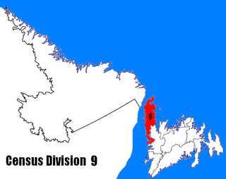
Census Division No. 9 is composed of the area of the province of Newfoundland and Labrador called the Northern Peninsula. It has a land area of 13,527.12 km² and had a population of 15,607 at the 2016 census. The largest community is the town of St. Anthony, near its northern tip, on the Atlantic Ocean coast.

The Town of Cape Broyle is an incorporated community located on the Avalon Peninsula in Newfoundland and Labrador, Canada. During King William's War, the village was destroyed in the Avalon Peninsula Campaign.

Norris Point is a community in the Canadian province of Newfoundland and Labrador.

Comfort Cove-Newstead is a small fishing community located outside Campbellton, on the east coast of Newfoundland and Labrador, Canada,.
Little Rapids is a local service district and designated place in the Canadian province of Newfoundland and Labrador. It is east of Corner Brook.
Mainland is a local service district and designated place in the Canadian province of Newfoundland and Labrador. It is on the western shore of the Port au Port Peninsula approximately 50 kilometres (31 mi) from the Stephenville International Airport. Mainland is a coastal community, bordered by both the ocean and forest. The main industry in the community has traditionally been fishing, but currently (2016) a large portion of the inhabitants leave the community seasonally to earn income.

Black Duck Brook and Winterhouse is a local service district and designated place in the Canadian province of Newfoundland and Labrador. It consists of the unincorporated fishing settlements of Black Duck Brook and Winterhouse on the Port au Port Peninsula. The communities had a combined population of 57 in the Canada 2006 Census.
Snook's Arm is a designated place in the Canadian province of Newfoundland and Labrador. The community was entirely resettled in 2018.
Eddies Cove West is a local service district and designated place in the Canadian province of Newfoundland and Labrador.
Blaketown is a local service district and designated place in the Canadian province of Newfoundland and Labrador.
Black Duck Cove is a local service district and designated place in the Canadian province of Newfoundland and Labrador. It is on the Great Northern Peninsula of Newfoundland.
Patrick's Cove-Angels Cove is a local service district and designated place in the Canadian province of Newfoundland and Labrador. It is on the Cape Shore of the Avalon Peninsula. The area was first settled by James Coffey in the early 19th century. Coffey had moved to Newfoundland from County Waterford, Ireland to work at Placentia's Saunders and Sweetman firm. Sweetman's firm had sent some of their employees outward from Placentia to start farms in which to supply Sweetman's with produce. Coffey became the first resident of this community.
Wild Cove is a local service district and designated place in the Canadian province of Newfoundland and Labrador. It is on the Baie Verte Peninsula of the island of Newfoundland.
Bear Cove is a local service district and designated place in the Canadian province of Newfoundland and Labrador on the northern peninsula of the island of Newfoundland.
Ship Cove is a local service district and designated place in the Canadian province of Newfoundland and Labrador on the northern peninsula of the island of Newfoundland.


