This article needs additional citations for verification .(October 2019) |
Birchy Bay | |
---|---|
Town | |
Location of Birchy Bay in Newfoundland | |
Coordinates: 49°21′40.11″N54°43′38.22″W / 49.3611417°N 54.7272833°W | |
Country | Canada |
Province | Newfoundland and Labrador |
Government | |
• Mayor | Jason Casacoup |
Area | |
• Land | 49.52 km2 (19.12 sq mi) |
Population (2021) | |
• Total | 511 |
Time zone | UTC-3:30 (Newfoundland Time) |
• Summer (DST) | UTC-2:30 (Newfoundland Daylight) |
Area code | 709 |
Highways | Route 340 |
Birchy Bay is a small community found in Notre Dame Bay in the province of Newfoundland and Labrador, Canada.
The name Birchy Bay is derived from the many birch trees which were found on its shores many years ago. Birchy Bay was first home to the native people of the Island which would have used the river which flows through the community as a source of fresh water and also to procure salmon and trout.
Tradition shows that there was a European fisherman shot at but not killed by a Beothuk man who used a decoy to lure the man within shot. The local lookout as known today was also recorded to have been used by the Beothuk and a large pine tree which grew at its summit was relieved of all its bark from the natives climbing to watch over the surrounding land.
The first recorded family to come and stay in Birchy Bay was Andrew Canning Sr. a man with unknown origins but came from Barr'd Islands to salmon fish. The family lived on the tilt and latter returned to Fogo Island when his sons died he returned to Barr'd Island. The grandson of Andrew Sr., John Canning returned to Birchy Bay with his wife in 1886 along came his adoptive sister Amelia Diamond Mews and James Mews. They began to farm in the community after the agriculture act of 1886. Soon after families such as the Quinlans, Osmond's and Popes came to settle in Birchy Bay. Birchy bays chief income was the logging industry in the early 1900s the French family of Summerford opened a steam-powered sawmill procuring lumber from the country and driving it down the streams and brooks. Also the lobster fishery along with trapping was another means of income in the early days.
In the 2021 Census of Population conducted by Statistics Canada, Birchy Bay had a population of 511 living in 226 of its 267 total private dwellings, a change of -7.1% from its 2016 population of 550. [1] With a land area of 49.33 km2 (19.05 sq mi), it had a population density of 10.4/km2 (26.8/sq mi) in 2021. [2]
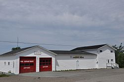
While the town has a council and small volunteer fire department, consumers are limited to a seasonal museum on local history, a seasonal restaurant named Nick's, a small convenience store boasting a single fuel pump, and numerous churches. There has also been construction done at a popular swimming area called 'Deep Hole' to allow for easy family gatherings and summer activities.
Sunnyside is a town on the Avalon Peninsula in Newfoundland and Labrador, Canada. It is in Division 1 on Bull Arm.
Fogo Island is the largest of the offshore islands of Newfoundland and Labrador, Canada. The Town of Fogo Island encompasses Fogo, Joe Batt's Arm-Barr'd Islands-Shoal Bay, Seldom-Little Seldom and Tilting, with the unincorporated areas of Fogo Island. It lies off the northeast coast of Newfoundland, northwest of Musgrave Harbour across Hamilton Sound, just east of the Change Islands. The island is about 25 km (16 mi) long and 14 km (8.7 mi) wide. The total area is 237.71 km2 (91.78 sq mi).
Division No. 8 is a census division on the north coast of the island of Newfoundland in the province of Newfoundland and Labrador, Canada. It has a land area of 9,314.57 km² and had a population of 33,940 at the 2016 census. Its largest communities are the towns of Lewisporte, Springdale, and Twillingate.
Victoria is a landlocked town on the Avalon Peninsula in Newfoundland and Labrador, Canada, located approximately midway on the Bay de Verde Peninsula portion of the Avalon Peninsula.
Aspen Cove is a small fishing community in the province of Newfoundland and Labrador, Canada. Formerly called Aspey or Apsey Cove, Aspen Cove was named for the presence of aspen trees in the area. It first appears in the 1857 Census as Apsey Cove with a population of thirteen, all dependent on the salmon fishery. By the 1870s more families moved to Aspen Cove for the cod and lobster fisheries. In the 1921 census the population had reached 104 and the economy had changed from salmon, fur, and agriculture to cod, lobster, and lumbering.
Boyd's Cove, also known as Boyd's Harbour, is a local service district and designated place in the Canadian province of Newfoundland and Labrador that is near Lewisporte. There is an interpretive centre dedicated to the earlier indigenous Beothuk settlement at this location.
Peterview is a town located in the Exploits Valley area of central Newfoundland and Labrador, Canada, where Peters River empties into the Bay of Exploits, just south of Botwood, off Route 350.
Census Division No. 9 is composed of the area of the province of Newfoundland and Labrador called the Northern Peninsula. It has a land area of 13,527.12 km² and had a population of 15,607 at the 2016 census. The largest community is the town of St. Anthony, near its northern tip, on the Atlantic Ocean coast.
Pilley's Island is a town located on the island of the same name in the Canadian province of Newfoundland and Labrador. It is located in Division No. 8, Newfoundland and Labrador.
Colinet is an incorporated town located on the northwest arm of St. Mary's Bay in Newfoundland and Labrador, Canada.
Campbellton is a small lumbering and fishing community located on the island of Newfoundland at Indian Arm, Notre Dame Bay. The community was originally named Indian Arm due to a Beothuk village located on the nearby Indian Arm River. It was renamed to Campbellton in honor of the sawmill manager John Campbell.
Baytona is a small rural community found in Newfoundland and Labrador. It is situated off of Route 340, which runs from Lewisporte to Twillingate island, aptly named "Road to the Isles". A bay separates Baytona from a neighboring town called Birchy Bay. The first settlers of Baytona were fishermen, with women mainly staying home to raise children; however, with a depletion in cod stocks and lobsters, there was a shift away from the fishing industry.
Indian Bay is located in Newfoundland, Canada.
Salvage is a town located on the Eastport Peninsula of the Canadian province of Newfoundland and Labrador. The town had a population of 108 in the Canada 2021 Census.
Great Brehat is a local service district and designated place in the Canadian province of Newfoundland and Labrador. It is on the Great Northern Peninsula of the island of Newfoundland, 10 km north of St. Anthony. As fishing has declined, the village has become a tourist attraction.
Buchans Junction is a local service district and designated place in the Canadian province of Newfoundland and Labrador in the central part of the island of Newfoundland. It is on the banks of Mary March River near where the Mary March River flows into the northeast end of Beothuk Lake. The community is on a site first known as "Four Mile Siding" on the railway which was constructed in 1900 to connect the community of Millertown to the Newfoundland Railway at Millertown Junction. The site itself became a rail junction in 1927 when Asarco subsidiary, the Buchans Mining Company, completed a rail link from the newly formed mining town of Buchans. Ever since 1927, even after the Buchans Railway closed in 1977, the community has been known as "Buchans Junction".
Birchy Cove is a local service district and designated place in the Canadian province of Newfoundland and Labrador.
New Harbour is a local service district and designated place in the Canadian province of Newfoundland and Labrador. It is on the east shore of Trinity Bay, along Provincial Route 80. Route 80's intersection with Route 73 is inside New Harbour.
Lodge Bay is a local service district and designated place in the Canadian province of Newfoundland and Labrador. It is on the southeast coast of Labrador. Encompassing a population of less than one hundred residents, the community has uniquely evolved from both early European colonization of Labrador, and the inimitable patterns of land and resource use by the migratory Inuit population. The name Lodge Bay originated from the title Ranger Lodge, which was the name given to the area by trader and explorer, Captain George Cartwright in the late 18th century. "Ranger" was the name of the wooden-mercantile ship Cartwright used to trade, map and explore the Labrador coast, while "Lodge" was the name given to English hunting camps in Great Britain at that time.
Fogo Island is a town located on Fogo Island, the largest of the offshore islands in the province of Newfoundland and Labrador, Canada.