Clarenville is a town on the east coast of Newfoundland in the province of Newfoundland and Labrador, Canada. Clarenville was incorporated in 1951. It is located in the Shoal Harbour valley, fronting an arm of the Atlantic Ocean called Random Sound.

Gambo is a town and designated place in the Canadian province of Newfoundland and Labrador. It is in the northeastern portion of the island of Newfoundland on Freshwater Bay. It is in Division No. 7.

Corner Brook is a city located on the west coast of the island of Newfoundland in the province of Newfoundland and Labrador, Canada. Corner Brook is the fifth largest settlement in Newfoundland and Labrador.

Stephenville is a town in Newfoundland and Labrador, Canada, on the west coast of the island of Newfoundland.

Deer Lake is a town in the western part of the island of Newfoundland in the province of Newfoundland and Labrador, Canada.

Pasadena is an incorporated town located in census division 5 which is in the western portion of Newfoundland, Canada. The community is situated on the shores of Deer Lake at the junction of the North Arm Valley and the Humber Valley.

Port Hope Simpson is a town located on the southeastern Labrador coast, 215 km (134 mi) from the Quebec/Labrador border in Canada. It was founded in 1934 as a company town.
Cormack is a farming community on the Great Northern Peninsula of Newfoundland.

Stephenville Crossing is a town in the Canadian province of Newfoundland and Labrador. It is on the island of Newfoundland at the easternmost limit of Bay St. George.
George's Brook is a designated place in the Canadian province of Newfoundland and Labrador that is a neighbourhood in the Town of George's Brook-Milton. It is north of Clarenville.
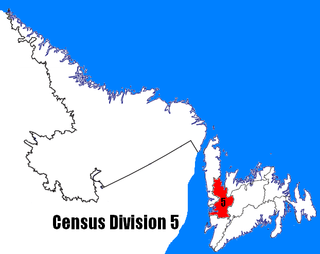
Census Division No. 5 is a Statistics Canada statistical division composed of the areas of the province of Newfoundland and Labrador called Humber Valley, Bay of Islands, and White Bay. It covers a land area of 10,365.63 km², and had a population of 42,014 according to the 2016 census.
Barachois Brook is a local service district and designated place in the Canadian province of Newfoundland and Labrador. It is on the western coast of the province, on Bay St. George, located just 5 km south of Stephenville Crossing.
Massey Drive is a Canadian town located on the west coast of the island of Newfoundland in the province of Newfoundland and Labrador. Its name is derived from the original road through the town, named Massey Drive, which in turn is named after Vincent Massey, former Governor General of Canada (1952–59). It is adjacent to the city of Corner Brook, from which it seceded in 1971. It is primarily a residential area.

Burnt Islands is a small coastal community found in God Bay on the southwest coast of Newfoundland, Canada.
Fermeuse is a town in the Canadian province of Newfoundland and Labrador. The town had a population of 266 in the Canada 2021 Census.
Hughes Brook is a town in the Canadian province of Newfoundland and Labrador. The town had a population of 236 in the Canada 2021 Census. It is located to the northeast of Corner Brook, in the western Bay of Islands area.

Irishtown-Summerside is a town in the Canadian province of Newfoundland and Labrador. It is located about 2.5 miles north of Corner Brook. The Post Office was established on March 1, 1965 and the first Postmistress was Blanch Anderson. The town had a population of 1,418 in the Canada 2016 Census. This contiguous settlement was formerly two separate villages, one of which was known originally as Petipas Cove. Two smaller settlements were formerly both separately reported in the census.
South Brook is a town in the Canadian province of Newfoundland and Labrador. It is located in the center region of the island of Newfoundland. The town had a population of 420 in 2021, down from 482 in the Canada 2016 Census.
Little Rapids is a local service district and designated place in the Canadian province of Newfoundland and Labrador. It is east of Corner Brook.

Black Duck Brook and Winterhouse is a local service district and designated place in the Canadian province of Newfoundland and Labrador. It consists of the unincorporated fishing settlements of Black Duck Brook and Winterhouse on the Port au Port Peninsula. The communities had a combined population of 57 in the Canada 2006 Census.


