
Port au Port West-Aguathuna-Felix Cove is a small town located on the Port au Port Peninsula of the Island of Newfoundland, Canada. The nearest large service area is Stephenville.

Petty Harbour–Maddox Cove is a town of approximately 950 people located on the eastern shore of the Avalon Peninsula in the province of Newfoundland and Labrador, Canada. It is nestled deep in the heart of Motion Bay about 10 kilometres (6.2 mi) south of St. John's. The present town is approximately 200 years old, though the site has been continuously occupied since at least 1598. During King William's War, the village was raided by French forces in the Avalon Peninsula Campaign.

Sandy Cove is a town located on the Eastport Peninsula in Newfoundland and Labrador, Canada. It is located on Newman Sound, which is part of Bonavista Bay. It had a population of 120 in the 2021 census.
Three Rock Cove is a local service district and designated place in the Canadian province of Newfoundland and Labrador. It is northwest of Stephenville.
Triton is a town that lies on Triton Island just off the coast of northeastern Newfoundland, in the Canadian province of Newfoundland and Labrador. Triton is the economic center of Green Bay South. According to Statistics Canada, Triton's population fell from 983 in 2016 to 896 in 2021.
Upper Amherst Cove, is a local service district and designated place in the Canadian province of Newfoundland and Labrador.
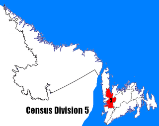
Census Division No. 5 is a Statistics Canada statistical division composed of the areas of the province of Newfoundland and Labrador called Humber Valley, Bay of Islands, and White Bay. It covers a land area of 10,365.63 km², and had a population of 42,014 according to the 2016 census.

Pouch Cove is a town in the Canadian province of Newfoundland and Labrador. The population is 2,063 according to the Canada 2021 Census. It is located on the northeast Avalon Peninsula, 27 kilometres north of St. John's, the province's capital city.

Elliston is an incorporated fishing settlement situated on the Bonavista Peninsula of Newfoundland, Canada. Incorporated in 1965, the town of Elliston was once called Bird Island Cove and it is composed of a number of communities, North Side, Noder Cover, Elliston Centre, Elliston Point, Porter's Point, Sandy Cove, The Neck and Maberly. Elliston is known as the Root Cellar Capital of the World and has claimed that title from the 135 root cellars that exist in the community.
Sheaves Cove is a local service district and designated place in the Canadian province of Newfoundland and Labrador. It is on the Port au Port Peninsula along the shore of St. George's Bay. There is a small tourist alcove just off the highway where views of the waterfalls and the ocean are visited often.
Ship Cove-Lower Cove-Jerry's Nose is a local service district and designated place in the Canadian province of Newfoundland and Labrador.

Humber Arm South is a town in the Canadian province of Newfoundland and Labrador. The town consists of the communities of Halfway Point, Benoit's Cove, John's Beach, and Frenchman's Cove. The town had a population of 1,537 in the Canada 2021 Census. The Town's Post Office is located in Benoit's Cove. Humber Arm South is located in the Bay of Islands and is in the Humber-Bay of Islands electoral district. The town's residents are of Mi'kmaw, Innu, and European descent.
Miles Cove is a town on Sunday Cove Island in the Canadian province of Newfoundland and Labrador. The town had a population of 104 in 2016, down from 140 in the Canada 2006 Census.
Parker's Cove or Parkers Cove is a town in the Canadian province of Newfoundland and Labrador. The town had a population of 233 in the Canada 2021 Census, a drop from 248 in 2016.

St. Brendan's is a town in the Canadian province of Newfoundland and Labrador, situated in Shoal Cove on Cottel Island in Bonavista Bay. Other settlements on the island include Shalloway Cove, Haywards Cove, and Dock Cove. The town had a population of 125 in the Canada 2021 Census. St. Brendan's is inaccessible by road and is served by a daily ferry service from Burnside.
Little Rapids is a local service district and designated place in the Canadian province of Newfoundland and Labrador. It is east of Corner Brook.
Mainland is a local service district and designated place in the Canadian province of Newfoundland and Labrador. It is on the western shore of the Port au Port Peninsula approximately 50 kilometres (31 mi) from the Stephenville International Airport. Mainland is a coastal community, bordered by both the ocean and forest. The main industry in the community has traditionally been fishing, but currently (2016) a large portion of the inhabitants leave the community seasonally to earn income.
Eddies Cove West is a local service district and designated place in the Canadian province of Newfoundland and Labrador.

Birchy Cove is a local service district and designated place in the Canadian province of Newfoundland and Labrador.
Random Sound West, previously known as Hillview-Adeytown-Hatchet Cove-St. Jones Within, is a local service district and designated place in the Canadian province of Newfoundland and Labrador.

