St. Anthony, Newfoundland and Labrador

Last updated

St. Anthony
Town
Stanthony 071904.jpg
St Anthony seal.png
Stanthony.JPG
Canada Newfoundland location map.svg
Red pog.svg
St. Anthony
Location of St. Anthony in Newfoundland
Canada Newfoundland and Labrador location map 2.svg
Red pog.svg
St. Anthony
St. Anthony (Newfoundland and Labrador)
Coordinates: 51°22′30″N55°36′59″W / 51.37500°N 55.61639°W / 51.37500; -55.61639
CountryCanada
Province Newfoundland and Labrador
Settledearly 16th century
Government
[1]
  Type Town Council
  MayorBrad Johannessen
Area
[2]
  Land37.02 km2 (14.29 sq mi)
Population
 (2021)
  Town2,180
  Density61.0/km2 (158/sq mi)
   Urban
1,986
Time zone UTC−03:30 (NST)
  Summer (DST) UTC−02:30 (NDT)
Area code 709
Highways NL Route 430.svg Route 430
Website www.stanthony.ca

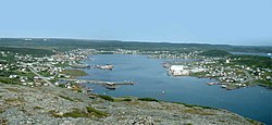
St. Anthony is a town on the northern reaches of the Great Northern Peninsula of the Canadian province of Newfoundland and Labrador. St. Anthony serves as a main service centre for northern Newfoundland and southern Labrador. St. Anthony had a population of 2,180 in 2021, compared with 2,258 in 2016, [2] 2,418 in 2011, 2,476 in 2006 and 2,730 in 2001.

Contents

L'Anse aux Meadows, which was designated a National Historic Site of Canada in 1968 and a World Heritage Site by UNESCO in 1978, is located 40 km from St. Anthony. [3] St. Anthony is the largest population centre on the Great Northern Peninsula.

History

The history of European settlement of St. Anthony reaches back to the early 16th century, when French and Basque fishermen used the well-sheltered harbour as a seasonal fishing station. By the time explorer Jacques Cartier came across the settlement in 1534, he reported it was named St. Anthony Haven.

More people began arriving in the mid-19th century. By 1857, a census found 71 inhabitants in 10 families. By 1874, the population rose to 110, and by 1891, it was 139.

The town grew in population after the arrival of Dr. Wilfred Grenfell in 1900 (see below).

A salt fish plant and cold storage facility built in the 1930s and 1940s were a boon to the local economy.

St. Anthony also became an outpost for the U.S. military. In 1951, a Pinetree Line radar site was built on a nearby hill, and by 1962, there were 250 servicemen stationed there. The site was operated by the 921st AC&W Squadron.

Tourism has become an important industry to the town as fishing stocks dwindled. Tourists come to visit historical sites related to Grenfell, to see the nearby Viking settlement at L'Anse aux Meadows or to see natural attractions such as icebergs and whales.

Dr. Wilfred Grenfell

Grenfell Memorial GrenfellMemorial.jpg
Grenfell Memorial

St. Anthony's most influential historic figure is Dr. Wilfred Grenfell. [4]

Born on February 28, 1865, in northern England, Grenfell entered the London Hospital Medical School in 1883. While in London, Grenfell heard the American evangelist Dwight L. Moody. The event inspired him to a life of Christian charity.

A member of the Royal National Mission To Deep Sea Fishermen, Grenfell was sent to investigate the conditions of fishermen in the Labrador region in 1892. [5] [6] He was said to be the first doctor to reach the region. He would later establish a string of hospitals, cooperatives and schools for people in remote Newfoundland and Labrador towns. [7] He chose Red Bay as the headquarters of the Grenfell Mission in 1900. However, in later years the focus of the organization became St. Anthony. He began responsibility of health care for the more than thirty thousand residents in Northern Newfoundland and Southern Labrador. This health responsibility was maintained until 1981 when the Government bought the resources and took over responsibility for the health service for one dollar. Dr. Grenfell was most interested in the holistic approach to betterment of the lifestyle of the people of the province. He worked in areas of food production, craft production and sale. Grenfell also worked to provide funds for his religious mission through speaking tours throughout the United States and Europe and he used colorized slides of the people and places he was operating his mission. He began to work from a non denominational Christian belief structure and religious conversion was his goal. Although the religious based mission was successful he was supported by volunteers who gave service to the mission. One notable volunteer was Josephine Colgate of the Colgate fortune.

Grenfell died in 1940 and his ashes were interred at Tea House Hill in St. Anthony with those of his wife Lady Anne Grenfell. Dr. Grenfell's contributions to the region are honoured by Grenfell Historic Properties, which comprises the Grenfell Interpretation Centre, the Grenfell House Museum, and the Grenfell Handicrafts Store. [8]

Demographics

In the 2021 Census of Population conducted by Statistics Canada, St. Anthony had a population of 2,180 living in 924 of its 1,036 total private dwellings, a change of

Historical populations
St. Anthony, NL
YearPop.±%
19511,380    
19561,761+27.6%
19611,820+3.4%
19662,269+24.7%
19712,593+14.3%
19762,987+15.2%
19813,107+4.0%
19863,180+2.3%
19913,164−0.5%
19962,996−5.3%
2001 2,730−8.9%
2006 2,476−9.3%
2011 2,418−2.3%
2016 2,258−6.6%
2021 2,180−3.5%
[2]

Climate

St. Anthony experiences a subarctic climate (Köppen climate classification Dfc) with long, cold winters and short, mild summers. However, owing to the strong maritime influence, the winters are milder than most of Canada at the same latitude, and there is no permafrost especially with snow cover sometimes reaching as high as 276 centimetres (108.7 in). However its winters are still far more severe than Valentia Island off the coast of Ireland half a degree of latitude farther north on the other side of the Atlantic which enjoys the moderating effects of the Gulf Stream. St. Anthony is as much as 11.4 °C (20.5 °F) colder than London on a near exact latitude in an average year. Precipitation, driven by the powerful Icelandic Low, is quite high year round, with an annual average of approximately 1,300 millimetres (51.2 in).

Climate data for St. Anthony (1981-2010)
MonthJanFebMarAprMayJunJulAugSepOctNovDecYear
Record high humidex 5.74.18.610.623.030.636.634.528.521.014.47.336.6
Record high °C (°F)6.0
(42.8)
6.7
(44.1)
9.4
(48.9)
14.1
(57.4)
22.8
(73.0)
27.4
(81.3)
28.2
(82.8)
30.0
(86.0)
24.3
(75.7)
20.0
(68.0)
13.2
(55.8)
8.3
(46.9)
30.0
(86.0)
Mean daily maximum °C (°F)−7.5
(18.5)
−8.0
(17.6)
−3.7
(25.3)
1.1
(34.0)
6.4
(43.5)
11.6
(52.9)
16.5
(61.7)
16.8
(62.2)
12.7
(54.9)
6.5
(43.7)
1.0
(33.8)
−3.8
(25.2)
4.1
(39.4)
Daily mean °C (°F)−11.8
(10.8)
−12.1
(10.2)
−7.4
(18.7)
−1.9
(28.6)
2.8
(37.0)
7.1
(44.8)
12.0
(53.6)
12.6
(54.7)
8.8
(47.8)
3.5
(38.3)
−1.9
(28.6)
−7.5
(18.5)
0.3
(32.5)
Mean daily minimum °C (°F)−16.1
(3.0)
−16.2
(2.8)
−11.1
(12.0)
−4.9
(23.2)
−0.8
(30.6)
2.7
(36.9)
7.4
(45.3)
8.4
(47.1)
4.9
(40.8)
0.4
(32.7)
−4.8
(23.4)
−11.3
(11.7)
−3.5
(25.7)
Record low °C (°F)−32.8
(−27.0)
−31.7
(−25.1)
−31.6
(−24.9)
−22.5
(−8.5)
−11.7
(10.9)
−3.1
(26.4)
−2.0
(28.4)
−0.3
(31.5)
−2.5
(27.5)
−10.7
(12.7)
−17.5
(0.5)
−30.6
(−23.1)
−32.8
(−27.0)
Record low wind chill −51.1−50.0−48.5−35.7−23.3−11.3−4.40.0−8.7−22.2−28.7−47.8−51.1
Average precipitation mm (inches)113.9
(4.48)
94.6
(3.72)
98.0
(3.86)
81.9
(3.22)
82.7
(3.26)
123.5
(4.86)
106.3
(4.19)
107.6
(4.24)
119.8
(4.72)
125.3
(4.93)
115.7
(4.56)
138.1
(5.44)
1,307.3
(51.47)
Average rainfall mm (inches)7.6
(0.30)
5.5
(0.22)
17.8
(0.70)
34.1
(1.34)
64.4
(2.54)
119.2
(4.69)
106.3
(4.19)
107.6
(4.24)
119.6
(4.71)
111.8
(4.40)
65.3
(2.57)
29.2
(1.15)
788.3
(31.04)
Average snowfall cm (inches)115.1
(45.3)
94.8
(37.3)
84.3
(33.2)
49.1
(19.3)
18.9
(7.4)
4.6
(1.8)
0.0
(0.0)
0.0
(0.0)
0.2
(0.1)
14.1
(5.6)
51.4
(20.2)
111.3
(43.8)
543.7
(214.1)
Average precipitation days (≥ 0.2 mm)19.416.617.515.715.616.917.215.315.417.717.921.2206.5
Average rainy days (≥ 0.2 mm)2.22.14.78.011.816.517.215.315.415.69.24.9122.9
Average snowy days (≥ 0.2 cm)18.815.714.910.35.51.40.00.00.24.511.919.7102.7
Source: [10]

Transportation

The town is at the end of the Great Northern Peninsula Highway. [11] It is also served by St. Anthony Airport.

Attractions

Grenfell Centre GrenfellCentre.jpg
Grenfell Centre
Grenfell Museum GrenfellMuseum.jpg
Grenfell Museum

Dr. Wilfred Grenfell's work in St. Anthony is commemorated by several historic sites and museums, including: [8]

Other attractions include:

Notable people

St. Anthony appears as a playable area in the 2014 videogame Assassin's Creed Rogue.

See also

Related Research Articles

<span class="mw-page-title-main">Vinland</span> Area of coastal Canada explored by Norse Vikings

Vinland, Vineland, or Winland was an area of coastal North America explored by Vikings. Leif Eriksson landed there around 1000 AD, nearly five centuries before the voyages of Christopher Columbus and John Cabot. The name appears in the Vinland Sagas, and describes Newfoundland and the Gulf of Saint Lawrence as far as northeastern New Brunswick. Much of the geographical content of the sagas corresponds to present-day knowledge of transatlantic travel and North America.

<span class="mw-page-title-main">Helge Ingstad</span> Norwegian explorer (1899–2001)

Helge Marcus Ingstad was a Norwegian explorer. In 1960, after mapping some Norse settlements, Ingstad and his wife archaeologist Anne Stine Ingstad found remnants of a Viking settlement in L'Anse aux Meadows in the province of Newfoundland in Canada. They were thus the first to prove conclusively that the Icelandic/Greenlandic Norsemen such as Leif Erickson had found a way across the Atlantic Ocean to North America, roughly 500 years before Christopher Columbus and John Cabot. He also thought that the mysterious disappearance of the Greenland Norse Settlements in the 14th and 15th centuries could be explained by their emigration to North America.

<span class="mw-page-title-main">Wilfred Grenfell</span> British medical missionary (1865–1940)

Sir Wilfred Thomason Grenfell was a British medical missionary to Newfoundland, who wrote books on his work and other topics.

<span class="mw-page-title-main">Helluland</span>

Helluland is the name given to one of the three lands, the others being Vinland and Markland, seen by Bjarni Herjólfsson, encountered by Leif Erikson and further explored by Thorfinn Karlsefni Thórdarson around AD 1000 on the North Atlantic coast of North America. As some writers refer to all land beyond Greenland as Vinland; Helluland is sometimes considered a part of Vinland.

<span class="mw-page-title-main">Anne Stine Ingstad</span> Norwegian archaeologist (1918–1997)

Anne Stine Ingstad was a Norwegian archaeologist who, along with her husband explorer Helge Ingstad, discovered the remains of a Norse settlement at L'Anse aux Meadows in the Canadian province of Newfoundland and Labrador in 1960.

The Grenfell Mission was a philanthropic organization that provided medical and social services to people in rural communities of northern Newfoundland and Labrador. It was founded by Sir Wilfred Grenfell in 1892 as a branch of The Royal National Mission to Deep Sea Fishermen based in Britain.

Quirpon is a local service district in the Canadian province of Newfoundland and Labrador. It is on the northern tip of the Great Northern Peninsula of the island of Newfoundland. It is the most northerly sheltered harbour on the island. This area was historically called "Ikkereitsock" by the Inuit.

<span class="mw-page-title-main">Great Northern Peninsula</span> Peninsula of Newfoundland, Canada

The Great Northern Peninsula is the largest and longest peninsula of Newfoundland, Canada, approximately 270 km long and 90 km wide at its widest point and encompassing an area of 17,483 km2. It is defined as that part of Newfoundland from Bonne Bay northwards around Cape Norman and Cape Bauld and thence southwards to the head of White Bay, bounded by the Gulf of St. Lawrence on the west, the Strait of Belle Isle on the north and the Labrador Sea and White Bay on the east.

<span class="mw-page-title-main">North West River</span> Town in Newfoundland and Labrador, Canada

North West River is a small town located in central Labrador. Established in 1743 as a trading post by French Fur Trader Louis Fornel, the community later went on to become a hub for the Hudson's Bay Company and home to a hospital and school serving the needs of coastal Labrador. North West River is the oldest modern settlement in Labrador.

<span class="mw-page-title-main">Newfoundland and Labrador Route 430</span> Highway in Newfoundland and Labrador, Canada

Route 430 is a 413-kilometre-long (257 mi) paved highway that traverses the Great Northern Peninsula of Newfoundland in the Canadian province of Newfoundland and Labrador. The route begins at the intersection of Route 1 in Deer Lake and ends in St. Anthony. Officially known as the Great Northern Peninsula Highway, it has been designated as the Viking Trail since it is the main auto route to L'Anse aux Meadows, the only proven Viking era settlement in North America. It is the primary travel route in the Great Northern Peninsula and the only improved highway between Deer Lake and St. Anthony. It is the main access route to the Labrador Ferry terminal in St. Barbe.

<span class="mw-page-title-main">St. Lunaire-Griquet</span> Town in Newfoundland and Labrador, Canada

St. Lunaire-Griquet is a town in the Canadian province of Newfoundland and Labrador. The town is located near the northern tip of the Great Northern Peninsula of Newfoundland. The town had a population of 603 in the Canada 2021 Census.

<span class="mw-page-title-main">L'Anse aux Meadows</span> Norse archaeological site in Newfoundland, Canada

L'Anse aux Meadows is an archaeological site, first excavated in the 1960s, of a Norse settlement dating to approximately 1,000 years ago. The site is located on the northernmost tip of the island of Newfoundland in the Canadian province of Newfoundland and Labrador near St. Anthony.

<span class="mw-page-title-main">Sop's Arm</span> Community in Newfoundland and Labrador, Canada

Sop's Arm is a local service district and designated place in the Canadian province of Newfoundland and Labrador. The community was formed in the 1930s and 1940s by families moving from surrounding communities, including Jackson's Arm. In the 1950s and 1960s families from nearby Sop's Island moved to Sop's Arm, towing their houses across the channel of water.

Great Brehat is a local service district and designated place in the Canadian province of Newfoundland and Labrador. It is on the Great Northern Peninsula of the island of Newfoundland, 10 km north of St. Anthony. As fishing has declined, the village has become a tourist attraction.

<span class="mw-page-title-main">Brig Bay</span>

Brig Bay is a local service district and designated place in the Canadian province of Newfoundland and Labrador. It was first mapped by Captain James Cook in September 1764. The name "Brig" was adopted by the French who occupied the bay prior to English occupation. It provided a safe and well-sheltered harbour.

<span class="mw-page-title-main">Newfoundland (island)</span> Island portion of Newfoundland and Labrador, Canada

Newfoundland is a large island situated off the eastern coast of the North American mainland and the western part of the Canadian province of Newfoundland and Labrador, referred to as Labrador.

<span class="mw-page-title-main">St. Barbe-L'Anse aux Meadows</span> Provincial electoral district in Newfoundland and Labrador

St. Barbe-L'Anse aux Meadows is a provincial electoral district in Newfoundland and Labrador, which is represented by one member in the Newfoundland and Labrador House of Assembly. It was contested for the first time in the 2015 provincial election. It was created out of all of The Straits-White Bay North and part of St. Barbe. St. Anthony is the largest population centre in the district.

<span class="mw-page-title-main">Newfoundland and Labrador Route 436</span> Highway in Newfoundland and Labrador, Canada

Route 436, also known as L'Anse aux Meadows Road, is a 29.1-kilometre-long (18.1 mi) north-south highway on the Great Northern Peninsula of Newfoundland in the Canadian province of Newfoundland and Labrador. Its southern terminus is an intersection on Route 430, and its northern terminus is at L'Anse aux Meadows, a world-famous archaeological site.

Birgitta Linderoth Wallace is a Swedish–Canadian archaeologist specialising in Norse archaeology in North America. She spent most of her career as an archaeologist with Parks Canada and is best known for her work on L'Anse aux Meadows, currently the only widely accepted Norse site in North America.

L'Anse aux Meadows to Quirpon is a local service district and designated place in the Canadian province of Newfoundland and Labrador.

References

  1. "Town of St. Anthony - Official Website". Town of St. Anthony. Retrieved November 9, 2020.
  2. 1 2 3 "Census Profile, 2016 Census: St. Anthony, Town [Census subdivision], Newfoundland and Labrador". Statistics Canada. 8 February 2017. Retrieved October 13, 2019.
  3. "L'Anse aux Meadows National Historic Site". UNESCO World Heritage Center. L'Anse aux Meadows is the first and only known site established by Vikings in North America and the earliest evidence of European settlement in the New World. As such, it is a unique milestone in the history of human migration and discovery.
  4. "Wilfred Grenfell Of Labrador Dead. Founder in 1892 of Medical Mission Known Throughout World Stricken in Vermont". New York Times . 10 October 1940. Retrieved 2014-01-17. Sir Wilfred Thomason Grenfell, founder of the Labrador Medical Mission, who devoted his life to caring for the spiritual and physical needs of Eskimos, Indians and fishermen of ...
  5. "Wilfred Thomason Grenfell (1865 - 1940)". Grenfell Family History Site. Retrieved 26 November 2010.
  6. "Labrador: The Inuit Experience". The Arctic Coastal Zone Management Newsletter. 9. Barrow, Alaska: North Slope Burough. February 1978. Retrieved 19 August 2016.
  7. Blair, Louisa (15 December 1991). "Dr. Wilfred Grenfell and the forgotten people of Newfoundland and Labrador". Canadian Medical Association Journal. 145 (12). Ottawa, Ontario, Canada: Canadian Medical Association: 1633–1635. ISSN   0820-3946. PMC   1336097 . PMID   1742705.
  8. 1 2 "Grenfell Historic Properties". www.grenfell-properties.com. Retrieved 2021-03-27.
  9. "Population and dwelling counts: Canada, provinces and territories, census divisions and census subdivisions (municipalities), Newfoundland and Labrador". Statistics Canada. February 9, 2022. Retrieved March 15, 2022.
  10. "Canadian Climate Normals 1981–2010" (CSV). Environment Canada . Retrieved 2016-05-09.
  11. Google. "Route 430 in Newfoundland and Labrador" (Map). Google Maps . Google.
  12. Properties, Grenfell. "The Jordi Bonet Murals". Province of Newfoundland and Labrador. Retrieved 22 June 2011.
  13. "History – Discovery of the Site and Initial Excavations (1960–1968)". L'Anse aux Meadows National Historic Site of Canada. Parks Canada. 4 April 2019.
  14. Bird, Lindsay (30 May 2018). "Archeological quest for Codroy Valley Vikings comes up short – Report filed with province states no Norse activity found at dig site". Canadian Broadcasting Corporation . Retrieved 19 June 2018.
  15. Wallace, Birgitta (2003). "The Norse in Newfoundland: L'Anse aux Meadows and Vinland". Newfoundland and Labrador Studies. 19 (1).
  16. Dooley, Danette. "Meet the first female mayor of St. Anthony: Howell dedicated to making a difference in her community | The Telegram". www.thetelegram.com. Retrieved 2021-03-28.