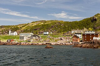
Lourdes, Newfoundland and Labrador

Last updated
Lourdes
Doors
Town
Canada Newfoundland location map.svg
Red pog.svg
Lourdes
Location of Lourdes in Newfoundland
Coordinates: 48°38′54″N58°59′50.3″W / 48.64833°N 58.997306°W / 48.64833; -58.997306
Country Flag of Canada (Pantone).svg  Canada
Province Flag of Newfoundland and Labrador.svg  Newfoundland and Labrador
Government
Population
 (2021) [1]
  Total502
Time zone UTC-3:30 (Newfoundland Time)
  Summer (DST) UTC-2:30 (Newfoundland Daylight)
Area code 709
Highways NL Route 463.svg Route 463

Lourdes is a town in the Canadian province of Newfoundland and Labrador. The town had a population of 465 in the Canada 2016 Census. The current mayor of Lourdes is Henry Gaudon. [2] [3]

Contents

The earliest settlers in the area came from Brittany in France. Originally, they came to fish around the western shores of Newfoundland and would return to France. However, eventually many started settling around the shores of the Port au Port Peninsula. Many took local Mi’kmaq women as wives.

Our Lady of Lourdes Parish, a Catholic church, contains a grotto which was built in 1987. A local stonemason, Michael Flavin, offered to carve a grotto into a natural outcrop of rock near the parish church. Flavin was reportedly inspired by the famous site in Lourdes, France, where the Virgin Mary had appeared to a young girl, he built a series of terraces and niches, creating a place for reflection and devotion. The Catholic Women's League of Our Lady of Lourdes Parish began raising funds, adding life-size statues of the Blessed Virgin Mary and Jesus the Redeemer. Later came a walkway, benches, and delicately carved Stations of the Cross. A rosary made of donated fishing buoys provides a nautical link between the parish and the sea. [4] [5] The site is a tourist attraction.

In 2015, a Chase the Ace lottery at Our Lady of Lourdes Parish received national attention due to the large jackpot. [6] [7] [8]

Demographics

In the 2021 Census of Population conducted by Statistics Canada, Lourdes had a population of 502 living in 227 of its 264 total private dwellings, a change of

See also

Related Research Articles

<span class="mw-page-title-main">Come By Chance, Newfoundland and Labrador</span> Town in Newfoundland and Labrador, Canada

Come By Chance is a town on the isthmus of the Avalon Peninsula in Newfoundland and Labrador, Canada. It is in Division 1 on Placentia Bay.

<span class="mw-page-title-main">St. Anthony, Newfoundland and Labrador</span> Town in Newfoundland and Labrador, Canada

St. Anthony is a town on the northern reaches of the Great Northern Peninsula of the Canadian province of Newfoundland and Labrador. St. Anthony serves as a main service centre for northern Newfoundland and southern Labrador. St. Anthony had a population of 2,180 in 2021, compared with 2,258 in 2016, 2,418 in 2011, 2,476 in 2006 and 2,730 in 2001.

<span class="mw-page-title-main">Lewisporte</span> Town in Newfoundland and Labrador, Canada

Lewisporte is a town in central Newfoundland, Canada, with a population of 3,288. It is situated in Burnt Bay which opens on to the Bay of Exploits. Lewisporte has a deep water port and related facilities that serve many communities in the region.

Piccadilly Slant-Abraham's Cove is a local service district and designated place in the Canadian province of Newfoundland and Labrador. It is located on the island of Newfoundland, along St. George's Bay, on the Port au Port Peninsula. The DPL consists of the fishing villages of Abraham's Cove and Piccadilly.

<span class="mw-page-title-main">Portugal Cove–St. Philip's</span> Town in Newfoundland and Labrador, Canada

Portugal Cove–St. Philip's is a rural seashore community located on the eastern Avalon Peninsula of Newfoundland in the province of Newfoundland and Labrador, Canada. The town is a bedroom community of the provincial capital of St. John's.

Port Kirwan is a small incorporated fishing community located on the southern shore of the Avalon Peninsula, Newfoundland, Canada.

<span class="mw-page-title-main">Blanc-Sablon, Quebec</span> Municipality in Quebec, Canada

Blanc-Sablon is the easternmost community in Le Golfe-du-Saint-Laurent Regional County Municipality, in the administrative région of Côte-Nord, in the province of Quebec, Canada. With a population of 1,122 inhabitants in 2021, it is the most populous community in the county municipality.

<span class="mw-page-title-main">Rencontre East</span> Town in Newfoundland and Labrador, Canada

Rencontre East is a small, outport community in Newfoundland and Labrador, Canada located north east of Belleoram, and west of Terrenceville in Fortune Bay. The population was 115 in the 2021 census. This small community is not connected to any surrounding areas by road but is accessible by scheduled ferry service from ports in Pool's Cove and Bay L'Argent.

<span class="mw-page-title-main">Rose Blanche-Harbour le Cou</span> Town in Newfoundland and Labrador, Canada

Rose Blanche – Harbour le Cou is a small town on Newfoundland's southwest shore, about 45 km at the end of Route 470 from Port aux Basques. This community is located in a barren area on the east side of a small bay. In this bay there are 2 harbours that were mainly used to provide shelter for fishing vessels. Scenery includes the rugged granite coastline, and the white and rocky cliffs of "Diamond Cove". Its granite lighthouse was in operation from 1873 to the 1940s. After it was abandoned in the 1940s the building fell into ruins. The spiral stone staircase extends into the tower wall and kept the tower from collapsing while the remainder of the lighthouse fell to ruin. In 1999 the lighthouse was fully reconstructed and serves as a tourist attraction.

Dover is a small incorporated fishing and lumbering village located in a small cove at the head of Freshwater Bay, Bonavista Bay, Newfoundland, Canada. Settled in the early 1890s it was originally known as Shoal Bay, presumably from its many shallow coves and inlets in the area. From the 1950s to the 1970 Shoal Bay was referred to as Wellington , whereas the local residents called it Dover.

<span class="mw-page-title-main">Nipper's Harbour</span> Town in Newfoundland and Labrador, Canada

Nipper's Harbour is a town located on the east coast of the Baie Verte Peninsula of Newfoundland in the Canadian province of Newfoundland and Labrador. This incorporated community of 85 people is located on a rocky inlet that combines Nipper's Harbour and Noble's Cove, and where the primary industry is the inshore fishery. The town is approximately 58 km from Baie Verte.

<span class="mw-page-title-main">Pouch Cove</span> Town in Newfoundland and Labrador, Canada

Pouch Cove is a town in the Canadian province of Newfoundland and Labrador. The population is 2,063 according to the Canada 2021 Census. It is located on the northeast Avalon Peninsula, 27 kilometres north of St. John's, the province's capital city.

Grand Bruit is a designated place and former settlement in the Canadian province of Newfoundland and Labrador. It is on the southwestern coast of the island of Newfoundland. Grand Bruit was resettled in 2010. The community was divided down the middle by a waterfall, hence the name "Grand Bruit" which is French for "great noise".

<span class="mw-page-title-main">Flatrock, Newfoundland and Labrador</span> Town in Newfoundland and Labrador, Canada

Flatrock is a town in Newfoundland and Labrador. The town had a population of 1,722 in the Canada 2021 Census.

<span class="mw-page-title-main">McIvers</span> Town in Newfoundland and Labrador, Canada

McIvers is a town in the Canadian province of Newfoundland and Labrador. The town had a population of 575 in the Canada 2021 Census. The town celebrated its Come Home Year in 2017, following a successful Chase the Ace fundraiser the previous year which largely funded the event. The town is located on the north shore of the Bay of Islands, Newfoundland and Labrador.

Pacquet is a town in the Canadian province of Newfoundland and Labrador. The town had a population of 164 in 2016, down from 184 in the Canada 2011 Census.

Port au Port East is a town in the Canadian province of Newfoundland and Labrador. The town had a population of 413 in the Canada 2021 Census. The town consists of the unincorporated communities of Port au Port and Romaines.

Lushes Bight–Beaumont–Beaumont North is a town on Long Island in Notre Dame Bay in the Canadian province of Newfoundland and Labrador. The town had a population of 169 at the 2021 Census, down from 275 in the 2006 Census.

<span class="mw-page-title-main">Black Duck Brook and Winterhouse, Newfoundland and Labrador</span>

Black Duck Brook and Winterhouse is a local service district and designated place in the Canadian province of Newfoundland and Labrador. It consists of the unincorporated fishing settlements of Black Duck Brook and Winterhouse on the Port au Port Peninsula. The communities had a combined population of 57 in the Canada 2006 Census.

St. Barbe is an unincorporated settlement in Newfoundland and Labrador. It is located on the Great Northern Peninsula of the island of Newfoundland near Pigeon Cove. St. Barbe and Pigeon Cove together have a population of 135 as of 2016.

References

  1. 1 2 "Population and dwelling counts: Canada, provinces and territories, census divisions and census subdivisions (municipalities), Newfoundland and Labrador". Statistics Canada. February 9, 2022. Retrieved March 15, 2022.
  2. "Newfoundland and Labrador Municipalities Directory". 26 July 2016. Retrieved 2020-10-31.
  3. "Lourdes Mayor Henry Gaudon resigns; deputy mayor Anne Bullen shocked". SaltWire Network. Oct 10, 2017. Retrieved 2020-10-31.
  4. "Our Lady of Lourdes Parish celebrates 100 years | SaltWire".
  5. "Lourdes Land Settlement Site Municipal Heritage Site". HistoricPlaces.ca. 2007-06-19. Retrieved 2021-12-30.
  6. "Lourdes man takes home $329,460 in Chase the Ace | SaltWire".
  7. "Lourdes' Sheldon Greene takes $329K prize at Chase the Ace". CBC News . August 17, 2015.
  8. "Fundraiser gone wild: thousands flock to Lourdes for Chase the Ace lottery". CBC News . August 11, 2015.

Coordinates: 48°38′54″N58°59′50.3″W / 48.64833°N 58.997306°W / 48.64833; -58.997306