
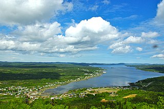
Peterview is a town located in the Exploits Valley area of central Newfoundland and Labrador, Canada, where Peters River empties into the Bay of Exploits, just south of Botwood, off Route 350.
Point Leamington is a town of about 590 people located north of Botwood and Grand Falls-Windsor in the Canadian province of Newfoundland and Labrador.
Cobb's Arm is a local service district and designated place in the Canadian province of Newfoundland and Labrador on New World Island. It is located about 8 km outside Newville and leads to other communities such as Pikes Arm and Toogood Arm.
Glenburnie-Birchy Head-Shoal Brook is a town in the Canadian province of Newfoundland and Labrador. The town had a population of 241 in the Canada 2021 Census.

Goose Cove East is a town in the Canadian province of Newfoundland and Labrador. The town had a population of 172 in the Canada 2021 Census.
Jackson's Arm is a town in the Canadian province of Newfoundland and Labrador, located on White Bay. It was settled by John Wicks of Christchurch, England, around 1870. The Post Office was established in 1892 and the first Postmistress was Belinda Peddle. The town had a population of 435 in 1956 and 277 as of the 2021 Canadian census. The primary industry of the town is fishing. In 2012, the local fish plant closed.
Lamaline is a town in the Canadian province of Newfoundland and Labrador. The town had a population of 480 in 1940, 643 in 1956 and 218 in the Canada 2021 Census. Lamaline was a small place with 10 families in 1864. The Way Office was established in 1863 and the first Waymaster was James Pittman.

La Scie is a town in the Canadian province of Newfoundland and Labrador. The town had a population of 820 in the Canada 2021 Census, down from 872 in 2016.

Leading Tickles is a town in the Canadian province of Newfoundland and Labrador. In 2021, the town had a population of 296, down from 407 in the Canada 2006 Census. It is located approximately 25 km Northwest of Point Leamington on the shores of Notre Dame Bay. The town boasts spectacular scenery especially in spring and early summer when many icebergs pass just off the coast.

McIvers is a town in the Canadian province of Newfoundland and Labrador. The town had a population of 575 in the Canada 2021 Census. The town celebrated its Come Home Year in 2017, following a successful Chase the Ace fundraiser the previous year which largely funded the event. The town is located on the north shore of the Bay of Islands, Newfoundland and Labrador.
Miles Cove is a town on Sunday Cove Island in the Canadian province of Newfoundland and Labrador. The town had a population of 104 in 2016, down from 140 in the Canada 2006 Census.
Point of Bay is a town in the Canadian province of Newfoundland and Labrador. The town had a population of 154 people in 2016, down from 163 in the Canada 2006 Census.
Port Anson is a town on Sunday Cove Island in the Canadian province of Newfoundland and Labrador. The town had a population of 42 in 2021, down from 155 in the Canada 2006 Census.
Sandringham is a town on the Eastport Peninsula in Bonavista Bay North in the Canadian province of Newfoundland and Labrador, Canada. The town had a population of 205 in the Canada 2021 Census.
Woodstock is a town in the Canadian province of Newfoundland and Labrador. The town had a population of 195 in 2021, up from 190 in the Canada 2016 Census.
Snook's Arm is a designated place in the Canadian province of Newfoundland and Labrador. The community was entirely resettled in 2018.
Loon Bay is a local service district and designated place in the Canadian province of Newfoundland and Labrador.
Brown's Arm is a local service district and designated place in the Canadian province of Newfoundland and Labrador
Roddickton-Bide Arm is a town located in the northern peninsula of the island of Newfoundland within the province of Newfoundland and Labrador. It was formed on January 1, 2009 through the amalgamation of the former towns of Roddickton and Bide Arm.

Roberts Arm is a small town located near Crescent Lake, Newfoundland and Labrador, Canada in Division No. 8, Newfoundland and Labrador. It is found on the northern part of Newfoundland. Roberts Arm boasts of its Lake Monster, Cressie, which is claimed to be living in Crescent Lake. Recent years saw the development of a majestic hiking trail which encompasses the end of the lake nearest to the community, Hazelnut Adventure Trail.
