Norris Arm

Last updated
Norris Arm
Town
Norrisarm.JPG
Motto(s): 
"The Town With The Sensational Sunset"
Canada Newfoundland location map.svg
Red pog.svg
Norris Arm
Location of Norris Arm in Newfoundland
Coordinates: 49°05′N55°16′W / 49.083°N 55.267°W / 49.083; -55.267 Coordinates: 49°05′N55°16′W / 49.083°N 55.267°W / 49.083; -55.267
Country Flag of Canada (Pantone).svg  Canada
Province Flag of Newfoundland and Labrador.svg  Newfoundland and Labrador
Census division 6
Settled1700s
Incorporated (town)1971
Government
  TypeNorris Arm Town Council
  MayorRoss Rowsell
   MP Clifford Small- PC
   MHA Pleaman Forsey- PC
Area
  Total41.49 km2 (16.02 sq mi)
Elevation
22 m (72 ft)
Population
 (2016) [1]
  Total737
  Density18/km2 (46/sq mi)
Time zone UTC-3:30 (Newfoundland Time)
  Summer (DST) UTC-2:30 (Newfoundland Daylight)
Postal Code Span
A0G
Area code(s) 709
Highways NL TCH sign.svg Route 1 (TCH)
NL Route 351.svg Route 351
Website https://municipalnl.ca/municipality/norris-arm/

Norris Arm is a town in north-central Newfoundland, Newfoundland and Labrador, Canada. It is in Division No. 6, on the Bay of Exploits.

Contents

Demographics

According to the 2016 [1] Statistics Canada Census:

Climate

Climate data for Norris Arm
MonthJanFebMarAprMayJunJulAugSepOctNovDecYear
Record high °C (°F)13.5
(56.3)
14
(57)
17
(63)
23.5
(74.3)
29
(84)
33
(91)
34
(93)
35
(95)
30
(86)
25.6
(78.1)
21.1
(70.0)
17.8
(64.0)
35
(95)
Average high °C (°F)−2
(28)
−2.2
(28.0)
1.7
(35.1)
6.4
(43.5)
13
(55)
18.8
(65.8)
23.4
(74.1)
22.1
(71.8)
17.1
(62.8)
11
(52)
5.9
(42.6)
0.5
(32.9)
9.7
(49.5)
Daily mean °C (°F)−6.8
(19.8)
−7.4
(18.7)
−3
(27)
2.2
(36.0)
7.8
(46.0)
13
(55)
17.7
(63.9)
16.7
(62.1)
12
(54)
6.7
(44.1)
2.2
(36.0)
−3.6
(25.5)
4.8
(40.6)
Average low °C (°F)−11.8
(10.8)
−12.8
(9.0)
−7.8
(18.0)
−2
(28)
2.5
(36.5)
7.1
(44.8)
11.9
(53.4)
11.3
(52.3)
6.9
(44.4)
2.4
(36.3)
−1.6
(29.1)
−7.9
(17.8)
−0.2
(31.6)
Record low °C (°F)−32.8
(−27.0)
−36.7
(−34.1)
−32
(−26)
−18.5
(−1.3)
−9.4
(15.1)
−3.5
(25.7)
0
(32)
−0.6
(30.9)
−3.3
(26.1)
−10
(14)
−20
(−4)
−33.3
(−27.9)
−36.7
(−34.1)
Average precipitation mm (inches)108
(4.3)
92.3
(3.63)
105.6
(4.16)
82.4
(3.24)
81.7
(3.22)
85.3
(3.36)
80.4
(3.17)
103.1
(4.06)
82.7
(3.26)
104.4
(4.11)
100.5
(3.96)
107.8
(4.24)
1,134.2
(44.65)
Source: 1961-1990 Environment Canada [2]

See also

Related Research Articles

Avondale, Newfoundland and Labrador Town in Newfoundland and Labrador, Canada

Avondale is a town located on Newfoundland's Avalon Peninsula in the province of Newfoundland and Labrador, Canada.

Conception Harbour Town in Newfoundland and Labrador, Canada

Conception Harbour is a town on the Avalon Peninsula in Newfoundland and Labrador, Canada. It is in Division 1 on Conception Bay.

Bishops Falls Town in Newfoundland and Labrador, Canada

Bishop's Falls is a town in the north-central part of the island of Newfoundland in the Canadian province of Newfoundland and Labrador, with a population of 3, 156 at the 2016 census.

Division No. 8 is a census division on the north coast of the island of Newfoundland in the province of Newfoundland and Labrador, Canada. It has a land area of 9,314.57 km² and had a population of 35,794 at the 2016 census. Its largest communities are the towns of Lewisporte, Springdale, and Twillingate.

Chapel Arm Town in Newfoundland and Labrador, Canada

Chapel Arm is a settlement in Newfoundland, Canada, located at the southeast corner of Trinity Bay, approximately 100 km (62 mi) west of St. John's and two km from the Trans-Canada Highway.

Burlington, Newfoundland and Labrador Town in Newfoundland and Labrador, Canada

Burlington is an incorporated town in Newfoundland and Labrador, Canada. It is a small fishing and lumbering community on Route 413 at the north side of the mouth of Green Bay. Burlington is located approximately 40 km from Baie Verte.

Division No. 6, Newfoundland and Labrador Census division in Newfoundland and Labrador, Canada

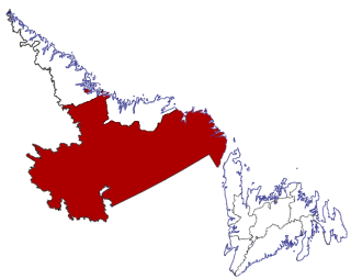
Division No. 6 is a census division in the central part of the island of Newfoundland in the province of Newfoundland and Labrador, Canada. It is divided into 16 parts; 12 towns and four unorganized subdivisions.

Rocky Harbour, Newfoundland and Labrador Town in Newfoundland and Labrador, Canada

Rocky Harbour is a town located on the western edge of Newfoundland, near the entrance to Bonne Bay. The harbour was previously known as Small Bay or Little Harbour. This town is home to Gros Morne National Park, a World Heritage Site.

Division No. 10, Newfoundland and Labrador Census division in Newfoundland and Labrador, Canada

Census Division No. 10 of Newfoundland and Labrador is composed of the Labrador region of the province, excluding Nunatsiavut. It has a land area of 199,703 km² (77,105.8 sq mi) and at the 2016 census had a population of 24,639, up from 24,111 in 2011. Its two major population centres are the towns of Happy Valley-Goose Bay and Labrador City.

Colinet, Newfoundland and Labrador Town in Newfoundland and Labrador, Canada

Colinet is an incorporated town located on the northwest arm of St. Mary's Bay in Newfoundland and Labrador, Canada.

Campbellton, Newfoundland and Labrador Town in Newfoundland and Labrador, Canada

Campbellton is a small lumbering and fishing community located on the island of Newfoundland at Indian Arm, Notre Dame Bay. The community was originally named Indian Arm due to a Beothuk village located on the nearby Indian Arm River. It was renamed to Campbellton in honor of the sawmill manager John Campbell.

Coxs Cove Town in Newfoundland and Labrador, Canada

Cox's Cove is a town in the Canadian province of Newfoundland and Labrador. The town had a population of 688 in the Canada 2016 Census. The small community is mainly based on the fishery, mink farm, and construction industries.

Humber Arm South Town in Newfoundland and Labrador, Canada

Humber Arm South is a town in the Canadian province of Newfoundland and Labrador. The town had a population of 1,599 in the Canada 2016 Census. The Town's Post Office is located in the section of the town referred to as Benoit's Cove. Humber Arm South is located in the Bay of Islands, and is in the Humber-Bay of Islands electoral district.

Middle Arm, Baie Verte Peninsula, Newfoundland and Labrador Town in Newfoundland and Labrador, Canada

Middle Arm is a village in the Canadian province of Newfoundland and Labrador. It is located on the northern shore of an inlet of Notre Dame Bay in the north-central part of Newfoundland.

Roddickton-Bide Arm Town in Newfoundland and Labrador, Canada

Roddickton-Bide Arm is a town located in the northern peninsula of the island of Newfoundland within the province of Newfoundland and Labrador. It was formed on January 1, 2009 through the amalgamation of the former towns of Roddickton and Bide Arm.

Fogo Island, Newfoundland and Labrador Town in Newfoundland and Labrador, Canada

Fogo Island is a town located on Fogo Island, the largest of the offshore islands in the province of Newfoundland and Labrador, Canada.

Caplin Cove-Southport, Newfoundland and Labrador Designated place in Newfoundland and Labrador

Caplin Cove-Southport is a designated place in Newfoundland and Labrador, Canada on the island of Newfoundland.

Norris Arm North, Newfoundland and Labrador Local service district / designated place in Newfoundland and Labrador, Canada

Norris Arm North is a local service district and designated place in the Canadian province of Newfoundland and Labrador.

Pensons Arm, Newfoundland and Labrador Local service district / designated place in Newfoundland and Labrador, Canada

Pensons Arm is a local service district and designated place in the Canadian province of Newfoundland and Labrador.

References

  1. 1 2 "Norris Arm Census Profile". Statistics Canada. Retrieved 11 December 2017.
  2. Environment Canada1961–1990. Retrieved 15 October 2012.