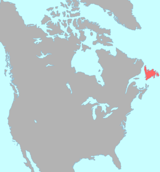
The Beothuk were a group of indigenous people who lived on the island of Newfoundland.

Bonavista—Gander—Grand Falls—Windsor was a federal electoral district in Newfoundland and Labrador, Canada, that was represented in the House of Commons of Canada from 2004 until 2015.

The Exploits River is a river in the province of Newfoundland and Labrador, Canada. It flows through the Exploits Valley in the central part of Newfoundland.

Beothuk, also called Beothukan, is an extinct language once spoken by the indigenous Beothuk people of Newfoundland. The Beothuk have been extinct since 1829, and there are few written accounts of their language. Hence, little is known about it, with practically no structural data existing for Beothuk.
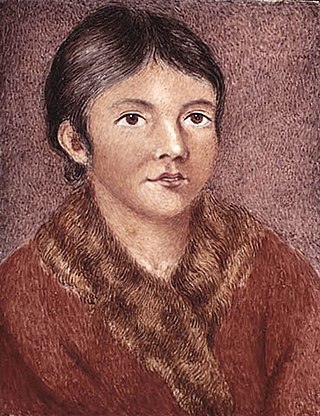
Demasduit was a Beothuk woman, one of the last of her people on Newfoundland.
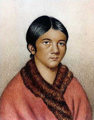
Shanawdithit, also noted as Shawnadithit, Shawnawdithit, Nancy April and Nancy Shanawdithit, was the last known living member of the Beothuk people, who inhabited Newfoundland, Canada. Remembered for her contributions to the historical understanding of Beothuk culture, including drawings depicting interactions with European settlers, Shanawdithit died of tuberculosis in St. John's, Newfoundland on June 6, 1829.

Twillingate is a town of 2,121 people located on the Twillingate Islands ("Toulinquet") in Notre Dame Bay, off the north eastern shore of the island of Newfoundland in the province of Newfoundland and Labrador, Canada. The town is about 100 kilometres (62 mi) north of Lewisporte and Gander.
William Epps Cormack was a Scottish explorer, philanthropist, agriculturalist and author, born St. John's, Newfoundland. Cormack was the first person of European descent to journey across the interior of the island. His account of his travels was first published in Britain in 1824. Interested in studying and trying to preserve Native culture, he founded the Beothick Institution in 1827.
Beothuk Lake, formerly Red Indian Lake, is located in the interior of central Newfoundland in the province of Newfoundland and Labrador, Canada. The lake drains into the Exploits River which flows through the interior of Newfoundland and exits into the Atlantic Ocean through the Bay of Exploits. Lloyds River, the Victoria River and Star River feed into the lake.

Boyd's Cove, also known as Boyd's Harbour, is a local service district and designated place in the Canadian province of Newfoundland and Labrador that is near Lewisporte. There is an interpretive centre dedicated to the earlier indigenous Beothuk settlement at this location.

Peterview is a town located in the Exploits Valley area of central Newfoundland and Labrador, Canada, where Peters River empties into the Bay of Exploits, just south of Botwood, off Route 350.
Springdale is a town in Newfoundland and Labrador, Canada, which had a population of 2,965 people in 2021, up from 2,764 in the Canada 2006 Census. The community is located on the Northwestern shores of Hall's Bay in Central Newfoundland, near the mouth of Indian River.
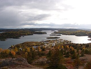
Pilley's Island is a town located on the island of the same name in the Canadian province of Newfoundland and Labrador. It is located in Division No. 8, Newfoundland and Labrador.
The Exploits Valley is a valley in the province of Newfoundland and Labrador in the central part of the island of Newfoundland.
Twillingate Islands are a group of islands in Notre Dame Bay of the island of Newfoundland in the province of Newfoundland and Labrador, Canada. There are two main islands, North Twillingate Island and South Twillingate Island, and several smaller islands that lie close to those; the largest is Burnt Island. The southern island is connected to New World Island via the Walter B. Elliott Causeway. The northern island is connected to the southern island by Tickle Bridge, which runs along Main Street in the town. The actual town of Twillingate is located on both islands.
Route 350, commonly known as Botwood Highway, is a side highway in Central Newfoundland that leads from the Trans-Canada Highway in Bishop's Falls to Botwood, Point Leamington and Leading Tickles. It is 70.7 kilometres (43.9 mi) in length and contains several side roads to communities located off the route, such as Peterview, and Route 352 that leads to Point of Bay and the Cottrell's Cove-Fortune Harbour area. Route 350-17 branches off in Point Leamington and connects the small community of Pleasantview to the main route. Route 350 continues on from Point Leamington for another 25 km north to Leading Tickles where the road officially ends. Along the way there is another short road connecting Glovers Harbour to the main route as well.
Fortune Harbour or Fortune Harbor is a designated place in the Canadian province of Newfoundland and Labrador.

Newfoundland is a large island situated off the eastern coast of the North American mainland and the most populous part of the Canadian province of Newfoundland and Labrador. The island contains 29 percent of the province's land area. The island is separated from the Labrador Peninsula by the Strait of Belle Isle and from Cape Breton Island by the Cabot Strait. It blocks the mouth of the Saint Lawrence River, creating the Gulf of Saint Lawrence, the world's largest estuary. Newfoundland's nearest neighbour is the French overseas collectivity of Saint Pierre and Miquelon.
John Peyton Sr. (1749–1829) was an English-born fisherman and trapper in the Colony of Newfoundland.
Burnt Bay is a small bay in the northeast of Newfoundland. It opens on to the Bay of Exploits and Notre Dame Bay to the north.


