The Beothuk were a group of Indigenous people of Canada who lived on the island of Newfoundland.

Bonavista—Gander—Grand Falls—Windsor was a federal electoral district in Newfoundland and Labrador, Canada, that was represented in the House of Commons of Canada from 2004 until 2015.

Humber—St. Barbe—Baie Verte was a federal electoral district in Newfoundland and Labrador, Canada, that was represented in the House of Commons of Canada from 1988 to 2015.
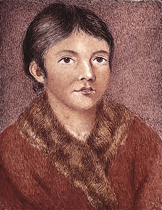
Demasduit was a Beothuk woman, one of the last of her people on Newfoundland.
The Victoria River is a tributary of the Exploits River in western Newfoundland, Canada.

Placentia is a town located in the Canadian province of Newfoundland and Labrador. It consists of the amalgamated communities of Placentia ("Townside"), Southeast Placentia, Freshwater, Dunville and Jerseyside and also includes the Argentia Industrial Park.
William Epps Cormack was a Scottish explorer, philanthropist, agriculturalist and author, born St. John's, Newfoundland. Cormack was the first person of European descent to journey across the interior of the island. His account of his travels was first published in Britain in 1824. Interested in studying and trying to preserve Native culture, he founded the Beothuk Institution in 1827.
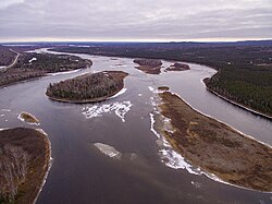
Beothuk Lake, formerly Red Indian Lake, is located in the interior of central Newfoundland in the province of Newfoundland and Labrador, Canada. The lake drains into the Exploits River which flows through the interior of Newfoundland and exits into the Atlantic Ocean through the Bay of Exploits. Lloyds River, the Victoria River and Star River feed into the lake.
Nonosabasut was a leader of the Beothuk people. Family head and partner of Demasduit, born on the island of Newfoundland. Sometimes referred to as Chief Nonosabasut, his stature within the last remaining Beothuk would better be described as that of a headman or leader.

Peterview is a town located in the Exploits Valley area of central Newfoundland and Labrador, Canada, where Peters River empties into the Bay of Exploits, just south of Botwood, off Route 350.
Springdale is a town in Newfoundland and Labrador, Canada, which had a population of 2,965 people in 2021, up from 2,764 in the Canada 2006 Census. The community is located on the Northwestern shores of Hall's Bay in Central Newfoundland, near the mouth of Indian River.

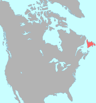
Newfoundland and Labrador is the easternmost province in Canada. The Strait of Belle Isle separates the province into two geographical regions, Labrador and the island of Newfoundland. The province also includes over seven thousand small islands.
The Exploits Valley is a valley in the province of Newfoundland and Labrador in the central part of the island of Newfoundland.

Birchy Bay is a small community found in Notre Dame Bay in the province of Newfoundland and Labrador, Canada.
South Brook is a town in the Canadian province of Newfoundland and Labrador. It is located in the center region of the island of Newfoundland. The town had a population of 420 in 2021, down from 482 in the Canada 2016 Census.
Halls Bay is a natural bay located near the Baie Verte Peninsula of the island of Newfoundland, in the Canadian province of Newfoundland and Labrador.

The Bay of Exploits is a large bay in the northeast of Newfoundland. It extends from the mouth of the Exploits River and opens on to Notre Dame Bay to the north. It is approximately 1,000 square kilometers in size and contains over 30 islands of which New World Island is the largest.

Newfoundland is a large island within the Canadian province of Newfoundland and Labrador. It is situated off the eastern coast of the North American mainland and the geographical region of Labrador.

The Qalipu First Nation, is a Mi'kmaq band government, created by order-in-council in 2011 pursuant to the Agreement for the Recognition of the Qalipu Mi'kmaq Band. After the band was approved as a First Nation, 100,000 people applied for membership and a total of 23,000 were approved.

Division No. 1, Subdivision G is an unorganized subdivision on the Avalon Peninsula in Newfoundland and Labrador, Canada. It is in Division 1 and contains the unincorporated communities of Baccalieu Island, Besom Cove, Bradley's Cove, Burnt Point, Caplin Cove, Daniel's Cove, Grates Cove, Gull Island, Job's Cove, Kingston, Long Beach, Lower Island Cove, Low Point, Northern Bay, Ochre Pit Cove, Red Head Cove, Riverhead, Smooth Cove and Western Bay.