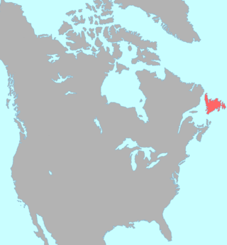
The Exploits Valley is a valley in the province of Newfoundland and Labrador in the central part of the island of Newfoundland.
The Exploits Valley is a valley in the province of Newfoundland and Labrador in the central part of the island of Newfoundland.
Formed by glaciation, the Exploits River flows eastward through the valley, framed by low hills from the high plateau in the centre of the island. The lower part of the valley hosts a dense, primarily evergreen, forest and large mammals such as woodland caribou, moose and black bears, as well as habitat for smaller animals and birds.
Human settlement came to the area several thousand years ago when the Beothuk Nation inhabited the region, living in fishing camps on the banks of the river during the summer and maintaining winter hunting camps at the upper end of the valley at Beothuk Lake. The river was used as a travel corridor as they spent summers fishing near the river's discharge point in the Bay of Exploits.
European settlement came first to coastal regions in the Bay of Exploits and Notre Dame Bay area, notably the fishing town of Twillingate, which is located on two neighbouring islands at the eastern edge of Notre Dame Bay. Its sheltered harbour and strategic position made it an important fishing haven for more than 200 years until the fishing of northern cod was banned in 1992. During the 18th century, it became known as the "Capital of the North" acting as the centre of trade for Labrador fisheries.
The Newfoundland Railway was constructed across the river at Bishop's Falls during the early 1890s, marking the beginning of industrial development in the valley.
The river was dammed for hydroelectric generation at historic waterfalls in Grand Falls and Bishop's Falls. This electricity powered local communities and a large pulp and paper mill in Grand Falls during the early 20th century.
The river becomes navigable below Bishop's Falls and the pulp and paper mill constructed a seaport on the lower reaches of the river at Botwood, which was connected to Grand Falls by an industrial railway.
An important ore deposit was discovered in the upper reaches of the Exploits Valley at the town of Buchans, resulting in sizable mines and another industrial railway line linking with the Newfoundland Railway west of Grand Falls.
During the mid-1960s the Trans-Canada Highway project constructed Route 1 through the lower part of the valley between Bishop's Falls and Badger.
A disastrous flood on the Exploits River in February 2003 caused by icejams forced the evacuation of the town of Badger.
The Beothuk were a group of indigenous people who lived on the island of Newfoundland.
Sunnyside is a town on the Avalon Peninsula in Newfoundland and Labrador, Canada. It is in Division 1 on Bull Arm.
Grand Falls-Windsor is a town located in the central region of the island of Newfoundland in the province of Newfoundland and Labrador, Canada, with a population of 13,853 at the 2021 census. The town is the largest in the central region, the sixth largest in the province, and is home to the annual Exploits Valley Salmon Festival. Grand Falls-Windsor was incorporated in 1991, when the two former towns of Grand Falls and Windsor amalgamated.
Badger is a town in north-central Newfoundland, Newfoundland and Labrador, Canada on the Exploits River. It supplied pulp and paper for the mills in Grand Falls for many years and was famous for its large spring log drives. The town is located in the interior of the island, twenty miles west of Grand Falls in Division No. 6. Badger was incorporated as a Town on September 30, 1963.

Bonavista—Gander—Grand Falls—Windsor was a federal electoral district in Newfoundland and Labrador, Canada, that was represented in the House of Commons of Canada from 2004 until 2015.

The Exploits River is a river in the province of Newfoundland and Labrador, Canada. It flows through the Exploits Valley in the central part of Newfoundland.
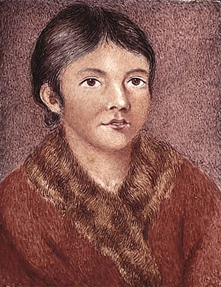
Demasduit was a Beothuk woman, one of the last of her people on Newfoundland.

The Newfoundland Railway was a narrow-gauge railway that operated on the island of Newfoundland from 1898 to 1988. With a total track length of 906 miles (1,458 km), it was the longest 3 ft 6 in narrow-gauge system in North America.

Twillingate is a town of 2,121 people located on the Twillingate Islands ("Toulinquet") in Notre Dame Bay, off the north eastern shore of the island of Newfoundland in the province of Newfoundland and Labrador, Canada. The town is about 100 kilometres (62 mi) north of Lewisporte and Gander.

Exploits is a provincial electoral district for the House of Assembly of Newfoundland and Labrador, Canada.
Newfoundland and Labrador Hydro, commonly known as Hydro, is a provincial Crown corporation that generates and delivers electricity for Newfoundland and Labrador, as well as portions of Quebec and the north-eastern areas of the United States. Between 2007 and 2021, NL Hydro was a subsidiary of the provincial Crown-owned energy holding company Nalcor Energy.
Beothuk Lake, formerly Red Indian Lake, is located in the interior of central Newfoundland in the province of Newfoundland and Labrador, Canada. The lake drains into the Exploits River which flows through the interior of Newfoundland and exits into the Atlantic Ocean through the Bay of Exploits. Lloyds River, the Victoria River and Star River feed into the lake.
Route 1 is a highway in the Canada province of Newfoundland and Labrador, and is the easternmost stretch of the Trans-Canada Highway. Route 1 is the primary east–west road on the island of Newfoundland.

Boyd's Cove, also known as Boyd's Harbour, is a local service district and designated place in the Canadian province of Newfoundland and Labrador that is near Lewisporte. There is an interpretive centre dedicated to the earlier indigenous Beothuk settlement at this location.
Nova Central School District was a school district headquartered in Gander in the Canadian province of Newfoundland and Labrador. The district had 66 schools located in 50 different communities, and served about 13,000 students, including a significant rural population. The District was formed by the merger of the Lewisporte-Gander and Baie Verte-Central-Connaigre school boards in 2004. The largest school in the district was Gander Academy. The district was replaced by the Newfoundland and Labrador English School District upon provincial amalgamation in 2013.

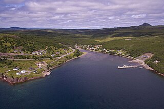
Campbellton is a small lumbering and fishing community located on the island of Newfoundland at Indian Arm, Notre Dame Bay. The community was originally named Indian Arm due to a Beothuk village located on the nearby Indian Arm River. It was renamed to Campbellton in honor of the sawmill manager John Campbell.

The Bay of Exploits is a large bay in the northeast of Newfoundland. It extends from the mouth of the Exploits River and opens on to Notre Dame Bay to the north. It is approximately 1,000 square kilometers in size and contains over 30 islands of which New World Island is the largest.

Division No. 1, Subdivision G is an unorganized subdivision on the Avalon Peninsula in Newfoundland and Labrador, Canada. It is in Division 1 and contains the unincorporated communities of Baccalieu Island, Besom Cove, Bradley's Cove, Burnt Point, Caplin Cove, Daniel's Cove, Grates Cove, Gull Island, Job's Cove, Kingston, Long Beach, Lower Island Cove, Low Point, Northern Bay, Ochre Pit Cove, Red Head Cove, Riverhead, Smooth Cove and Western Bay.