Cormack is a farming community on the Great Northern Peninsula of Newfoundland.

Peterview is a town located in the Exploits Valley area of central Newfoundland and Labrador, Canada, where Peters River empties into the Bay of Exploits, just south of Botwood, off Route 350.

Open Hall-Red Cliffe is a local service district and designated place in the Canadian province of Newfoundland and Labrador.
Woody Point is a town located in the heart of Gros Morne National Park, on the western coast of Newfoundland. Situated on Bonne Bay, the Town of Woody Point encompasses three areas: Curzon Village, Woody Point and Winterhouse Brook. It has a total population of 244 residents. Woody Point is a Registered Heritage District and has a waterfront with many heritage buildings and four Registered Newfoundland and Labrador Heritage Structures. The community is served by Route 431.

Reidville is a village located north east of Deer Lake. A post office was established in 1967 and the first Postmisstress was Dorothy Barrett.
Rocky Harbour is a town located on the western edge of Newfoundland, near the entrance to Bonne Bay. The harbour was previously known as Small Bay or Little Harbour. This town is home to Gros Morne National Park, a World Heritage Site.
Deep Bay is a designated place in the Canadian province of Newfoundland and Labrador.
Deadman's Bayis a local service district and designated place in the Canadian province of Newfoundland and Labrador. It is on the Straight Shore of Bonavista Bay near the community of Lumsden. The community is located near fishing grounds, contributing to its diversified and successful fishery despite its exposed, sandy coastline and harsh fall storms.

Frederickton is a designated place in the Canadian province of Newfoundland and Labrador.
Indian Bay is located in Newfoundland, Canada.
Point Leamington is a town of about 590 people located north of Botwood and Grand Falls-Windsor in the Canadian province of Newfoundland and Labrador.

Comfort Cove-Newstead is a small fishing community located outside Campbellton, on the east coast of Newfoundland and Labrador, Canada,.

Humber Arm South is a town in the Canadian province of Newfoundland and Labrador. The town consists of the communities of Halfway Point, Benoit's Cove, John's Beach, and Frenchman's Cove. The town had a population of 1,537 in the Canada 2021 Census. The Town's Post Office is located in Benoit's Cove. Humber Arm South is located in the Bay of Islands and is in the Humber-Bay of Islands electoral district. The town's residents are of Mi'kmaw, Innu, and European descent.

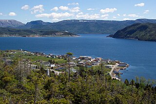
Leading Tickles is a town in the Canadian province of Newfoundland and Labrador. In 2021, the town had a population of 296, down from 407 in the Canada 2006 Census. It is located approximately 25 km Northwest of Point Leamington on the shores of Notre Dame Bay. The town boasts spectacular scenery especially in spring and early summer when many icebergs pass just off the coast.
Point of Bay is a town in the Canadian province of Newfoundland and Labrador. The town had a population of 154 people in 2016, down from 163 in the Canada 2006 Census.
Horwood is a local service district and designated place in the Canadian province of Newfoundland and Labrador. It was formerly known as Dog Bay. It is located northeast of Lewisporte just off of Route 331. It was once the home of a bustling lumber company owned by the Horwood family. Dog Bay was renamed Horwood after the family name.
Loon Bay is a local service district and designated place in the Canadian province of Newfoundland and Labrador.
Gander Bay South is a local service district and designated place in the Canadian province of Newfoundland and Labrador. Gander Bay was a small place in the Fogo and Twillingate area in 1864. It was north of Gander. The way office opened in 1885 and the first waymaster was John Bursey. It became a post office on May 30, 1891, and the first postmaster was James Rowsell. It had no population after 1940. They moved to Gander Bay South.
Wild Cove is a local service district and designated place in the Canadian province of Newfoundland and Labrador. It is on the Baie Verte Peninsula of the island of Newfoundland.
Gander Bay North is a local service district and designated place in the Canadian province of Newfoundland and Labrador.


