
St. Anthony is a town on the northern reaches of the Great Northern Peninsula of the Canadian province of Newfoundland and Labrador. St. Anthony serves as a main service centre for northern Newfoundland and southern Labrador. St. Anthony had a population of 2,180 in 2021, compared with 2,258 in 2016, 2,418 in 2011, 2,476 in 2006 and 2,730 in 2001.

L'Anse Amour is a small village on the Strait of Belle Isle in Labrador, a part of the Canadian province of Newfoundland and Labrador. As of 2006, it had a population of 8. The population of the village has not been officially counted since, though the total population of Subdivision 10A, which includes L'Anse Amour was 55 in 2021. L'Anse Amour is located along Route 510.

Grand Bank or 'Grand Banc' as the first French settlers pronounced it, is a small rural town in the Canadian province of Newfoundland and Labrador, with a population of 2,580. It is located on the southern tip or "toe" of the Burin Peninsula, 360 km from the province's capital of St. John's.
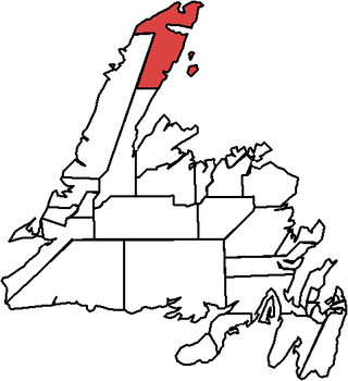
The Straits – White Bay North is a defunct provincial electoral district for the House of Assembly of Newfoundland and Labrador, Canada. The district was known as Strait of Belle Isle prior to the 1996 election. In the 2007 redistribution, it added five per cent of St. Barbe. As of 2011, there are 6,851 eligible voters living within the district.
Quirpon is a local service district in the Canadian province of Newfoundland and Labrador. It is on the northern tip of the Great Northern Peninsula of the island of Newfoundland. It is the most northerly sheltered harbour on the island. This area was historically called "Ikkereitsock" by the Inuit.

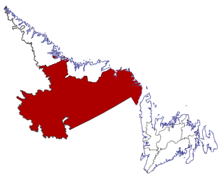
The Great Northern Peninsula is the largest and longest peninsula of Newfoundland, Canada, approximately 270 km long and 90 km wide at its widest point and encompassing an area of 17,483 km2. It is defined as that part of Newfoundland from Bonne Bay northwards around Cape Norman and Cape Bauld and thence southwards to the head of White Bay, bounded by the Gulf of St. Lawrence on the west, the Strait of Belle Isle on the north and the Labrador Sea and White Bay on the east.
Census Division No. 10 of Newfoundland and Labrador is composed of the Labrador region of the province, excluding Nunatsiavut. It has a land area of 199,703 km² (77,105.8 sq mi) and at the 2016 census had a population of 24,639, up from 24,111 in 2011. Its two major population centres are the towns of Happy Valley-Goose Bay and Labrador City.

Route 430 is a 413-kilometre-long (257 mi) paved highway that traverses the Great Northern Peninsula of Newfoundland in the Canadian province of Newfoundland and Labrador. The route begins at the intersection of Route 1 in Deer Lake and ends in St. Anthony. Officially known as the Great Northern Peninsula Highway, it has been designated as the Viking Trail since it is the main auto route to L'Anse aux Meadows, the only proven Viking era settlement in North America. It is the primary travel route in the Great Northern Peninsula and the only improved highway between Deer Lake and St. Anthony. It is the main access route to the Labrador Ferry terminal in St. Barbe.

Forteau is a town in the Canadian province of Newfoundland and Labrador. The town had a population of 377 as of the Canada 2021 Census.

Pinware is a town in the Canadian province of Newfoundland and Labrador. The town has a population of 64, according to the Canada 2021 Census.
Winterton is a town in the Canadian province of Newfoundland and Labrador. It was originally named Sille Cove or Scilly Cove. In 1912 the town was named Winterton for Sir James Spearman Winter, former Prime Minister of Newfoundland.

Witless Bay is a town on the Avalon Peninsula in the Canadian province of Newfoundland and Labrador. Located on the Irish Loop, 35 km south of the provincial capital, St. John's, Witless Bay is a small, scenic, traditional Newfoundland outport community. The town had a population of 1640 in the Canada 2021 Census. It is connected to the Witless Bay Ecological Reserve.
Seal Cove is a town in the Canadian province of Newfoundland and Labrador, located on White Bay. The town has had a stable population of just over 300 for more than a decade.

L'Anse aux Meadows is an archaeological site, first excavated in the 1960s, of a Norse settlement dating to approximately 1,000 years ago. The site is located on the northernmost tip of the island of Newfoundland in the Canadian province of Newfoundland and Labrador near St. Anthony.
Great Brehat is a local service district and designated place in the Canadian province of Newfoundland and Labrador. It is on the Great Northern Peninsula of the island of Newfoundland, 10 km north of St. Anthony. As fishing has declined, the village has become a tourist attraction.

Newfoundland is a large island within the Canadian province of Newfoundland and Labrador. It is situated off the eastern coast of the North American mainland and the geographical region of Labrador.
Médée Bay is a natural bay off the island of Newfoundland in the province of Newfoundland and Labrador, Canada. It faces the modern village and archeological site of L'Anse aux Meadows.

St. Barbe-L'Anse aux Meadows is a provincial electoral district in Newfoundland and Labrador, which is represented by one member in the Newfoundland and Labrador House of Assembly. It was contested for the first time in the 2015 provincial election. It was created out of all of The Straits-White Bay North and part of St. Barbe. St. Anthony is the largest population centre in the district.

Route 436, also known as L'Anse aux Meadows Road, is a 29.1-kilometre-long (18.1 mi) north-south highway on the Great Northern Peninsula of Newfoundland in the Canadian province of Newfoundland and Labrador. Its southern terminus is an intersection on Route 430, and its northern terminus is at L'Anse aux Meadows, a world-famous archaeological site.
L'Anse aux Meadows to Quirpon is a local service district and designated place in the Canadian province of Newfoundland and Labrador.

