Woody Point, Newfoundland and Labrador

Last updated

Woody Point
Town
Woody Point, Newfoundland.jpg
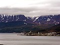
Woody Point from lookout
Canada Newfoundland location map.svg
Red pog.svg
Woody Point
Location of Woody Point in Newfoundland
Coordinates: 49°30′N57°56′W / 49.500°N 57.933°W / 49.500; -57.933
Country Flag of Canada (Pantone).svg  Canada
Province Flag of Newfoundland and Labrador.svg  Newfoundland and Labrador
Settled1849
Incorporated1956
Area
  Total2.91 km2 (1.12 sq mi)
Elevation
25 m (82 ft)
Population
 (2021)
  Total244
  Density84/km2 (220/sq mi)
Time zone UTC−3:30 (Newfoundland Time)
  Summer (DST) UTC−2:30 (Newfoundland Daylight)
Postal code span
A0K
Area code 709
Highways NL Route 431.svg Route 431
Woody Point lighthouse OOjs UI icon edit-ltr-progressive.svg
Woody Point Light.jpg
Woody Point Lighthouse in 2006
Constructed1919 (first)
1952 (second)
Constructionlumber (tower)  OOjs UI icon edit-ltr-progressive.svg
Height6 m (20 ft)  OOjs UI icon edit-ltr-progressive.svg
Shapesquare frustum tower with balcony and lantern [1] [2]
Markingswhite (tower), red (roof)  OOjs UI icon edit-ltr-progressive.svg
Power sourcesolar power  OOjs UI icon edit-ltr-progressive.svg
Operator Canadian Coast Guard   OOjs UI icon edit-ltr-progressive.svg
Heritageheritage lighthouse, municipal heritage site  OOjs UI icon edit-ltr-progressive.svg
First lit1959 (current)
Focal height14 m (46 ft)  OOjs UI icon edit-ltr-progressive.svg
Range4 nmi (7.4 km; 4.6 mi)  OOjs UI icon edit-ltr-progressive.svg
Characteristic Fl R 4s  OOjs UI icon edit-ltr-progressive.svg

Woody Point is a town located in the heart of Gros Morne National Park, on the western coast of Newfoundland. Situated on Bonne Bay, the Town of Woody Point encompasses three areas: Curzon Village, Woody Point and Winterhouse Brook. It has a total population of 244 residents. [3] Woody Point is a Registered Heritage District and has a waterfront with many heritage buildings and four Registered Newfoundland and Labrador Heritage Structures. The community is served by Route 431.

Contents

History

French Shore

Europeans were slow to settle the west coast of Newfoundland. The British were concentrated on the east coast, and the French were on the Grand Banks. The 1713 Treaty of Utrecht gave the French some area on the west coast which was extended in 1783 to the entire coast.

British settlement was spreading, as well. In 1800 the first British settlement in the Bonne Bay area occurred in Woody Point with the establishment of the firm of Joseph Bird from Sturminster Newton. He had an agent and premises to serve the British fishing interests which were principally migratory at this point. When fishermen began to stay during the winter rather than return to England, the pattern for permanent settlement was laid.

By 1904, the French had left the area to pursue fisheries farther up the coast. By this time, Woody Point was bustling. It was considered the capital of the area with banking and customs offices, merchants, and a harbour full of domestic and foreign vessels.

First settlers

John Roberts and his wife, Emma, together with their four children are considered to be the first settlers of Woody Point. They came in 1849. By 1872, there were 129 families residing in the Bonne Bay area.

In 1873, the Bonne Bay Post Office was established in the home of J.R. Roberts, John Roberts' nephew. This house was one of the first built in the area and is still standing today. It is a blue clapboarded structure on the Shore Road left of the downtown. Plans are being made to restore this house.

Solomon Wilton was the second settler to Woody Point. It was Wilton who donated the land on which the present day Church of the Epiphany was built. A school and parsonage once stood on this spot. These early founding families are laid to rest in the Anglican cemetery on Shore Road.

Major events

In 1922, when Woody Point was experiencing the height of its population and commercial success, a devastating fire ripped through the downtown. The wind quickly carried the flames which shot all the way across the Bay to Norris Point. In all, 58 buildings were destroyed. The degree of commerce in the town never returned to the pre-fire level.

Most of the buildings currently on the waterfront date from after 1922, but there are some exceptions. The lighthouse was built in 1919. Also, the large grey and green house to the right of the Seaside Deli was built in the 1890s. This house was the scene of a riot in 1938.[ citation needed ]

Gros Morne National Park overlooking Bonne Bay in Woody Point NLW BonneBay1 tango7174.jpg
Gros Morne National Park overlooking Bonne Bay in Woody Point

Geography and Climate

Woody Point is underlain by a bedrock of mélange, with metagabbro and related rock on higher areas. [4] Soils of the community and its surrounding region have been placed in the Serpentine Cove association. [5] Woody Point has a humid continental climate (Köppen Dfb) with extremely high winter snowfall and a strong winter seasonal lag, causing February to be the clearly coldest month. Summers are moderated by its seaside position, whereas precipitation remains high year round and rainfall is occurring during milder spells during winters. Woody Point is the snowiest year round inhabited place in Canada. [6]

Climate data for Woody Point
MonthJanFebMarAprMayJunJulAugSepOctNovDecYear
Record high °C (°F)15
(59)
12.8
(55.0)
16.5
(61.7)
22.5
(72.5)
25
(77)
27
(81)
29.5
(85.1)
30.6
(87.1)
27
(81)
22
(72)
18.5
(65.3)
16.1
(61.0)
30.6
(87.1)
Average high °C (°F)−3.5
(25.7)
−4.4
(24.1)
0
(32)
5.4
(41.7)
10.9
(51.6)
16.2
(61.2)
20.2
(68.4)
19.9
(67.8)
15.6
(60.1)
9.6
(49.3)
4.4
(39.9)
−0.7
(30.7)
7.8
(46.0)
Average low °C (°F)−10.7
(12.7)
−12.6
(9.3)
−8.6
(16.5)
−1.8
(28.8)
2.6
(36.7)
7.6
(45.7)
11.9
(53.4)
12.1
(53.8)
8.3
(46.9)
3.3
(37.9)
−1.1
(30.0)
−7
(19)
0.3
(32.5)
Record low °C (°F)−25
(−13)
−31
(−24)
−31
(−24)
−18
(0)
−7.2
(19.0)
−1
(30)
2.8
(37.0)
2.8
(37.0)
−1.7
(28.9)
−6.7
(19.9)
−13
(9)
−22.5
(−8.5)
−31
(−24)
Average precipitation mm (inches)230.9
(9.09)
128.3
(5.05)
99.4
(3.91)
68.6
(2.70)
80.2
(3.16)
113
(4.4)
112
(4.4)
124.9
(4.92)
133.7
(5.26)
163.2
(6.43)
168.9
(6.65)
197.6
(7.78)
1,620.7
(63.81)
Average rainfall mm (inches)28.1
(1.11)
17.1
(0.67)
30.5
(1.20)
47.2
(1.86)
76.2
(3.00)
113.0
(4.45)
112.0
(4.41)
124.9
(4.92)
133.7
(5.26)
160.5
(6.32)
119.8
(4.72)
35.0
(1.38)
998
(39.3)
Average snowfall cm (inches)202.8
(79.8)
111.2
(43.8)
68.8
(27.1)
21.4
(8.4)
4.0
(1.6)
0.0
(0.0)
0.0
(0.0)
0.0
(0.0)
0.0
(0.0)
2.8
(1.1)
49.1
(19.3)
162.6
(64.0)
622.7
(245.1)
Average precipitation days (≥ 0.2 mm)26.019.114.911.212.313.214.714.215.818.220.123.5203.2
Average rainy days (≥ 0.2 mm)3.52.44.57.511.613.214.714.215.817.812.45.0122.6
Average snowy days (≥ 0.2 cm)23.817.711.84.50.80.00.00.00.00.89.220.088.6
Source: Environment Canada [7]

Demographics

In the 2021 Census of Population conducted by Statistics Canada, Woody Point, Bonne Bay had a population of 244 living in 129 of its 207 total private dwellings, a change of

Arts and culture

Woody Point is home to the Writers at Woody Point festival [8] and Gros Morne Summer Music. [9]

See also

Related Research Articles

<span class="mw-page-title-main">Gros Morne National Park</span> National Park on the west coast of Newfoundland

Gros Morne National Park is a Canadian national park and World Heritage Site located on the west coast of Newfoundland. At 1,805 km2 (697 sq mi), it is the second largest national park in Atlantic Canada after Torngat Mountains National Park, which has an area of 9,700 km2 (3,700 sq mi).

<span class="mw-page-title-main">Sunnyside, Newfoundland and Labrador</span> Town in Newfoundland and Labrador, Canada

Sunnyside is a town on the Avalon Peninsula in Newfoundland and Labrador, Canada. It is in Division 1 on Bull Arm.

<span class="mw-page-title-main">Cape Spear</span> Cape in Newfoundland and Labrador, Canada

Cape Spear is a headland located on the Avalon Peninsula of Newfoundland near St. John's in the Canadian province of Newfoundland and Labrador. At a longitude of 52°37' W, it is the easternmost point in Canada and North America, excluding Greenland.

<span class="mw-page-title-main">Grand Bank</span> Town in Newfoundland and Labrador, Canada

Grand Bank or 'Grand Banc' as the first French settlers pronounced it, is a small rural town in the Canadian province of Newfoundland and Labrador, with a population of 2,580. It is located on the southern tip or "toe" of the Burin Peninsula, 360 km from the province's capital of St. John's.

<span class="mw-page-title-main">St. Barbe (electoral district)</span> Provincial electoral district in Newfoundland and Labrador, Canada

St. Barbe is a defunct provincial electoral district for the House of Assembly of Newfoundland and Labrador, Canada. As of 2011, there were 7,064 eligible voters living within the district. The district was abolished in 2015 and replaced by St. Barbe-L'Anse aux Meadows.

<span class="mw-page-title-main">Harbour Grace</span> Town in Newfoundland and Labrador, Canada

Harbour Grace is a town in Conception Bay on the Avalon Peninsula in the province of Newfoundland and Labrador, Canada. With roots dating back to the 16th century, it is one of the oldest towns in North America.

<span class="mw-page-title-main">Great Northern Peninsula</span> Peninsula of Newfoundland, Canada

The Great Northern Peninsula is the largest and longest peninsula of Newfoundland, Canada, approximately 270 km long and 90 km wide at its widest point and encompassing an area of 17,483 km2. It is defined as that part of Newfoundland from Bonne Bay northwards around Cape Norman and Cape Bauld and thence southwards to the head of White Bay, bounded by the Gulf of St. Lawrence on the west, the Strait of Belle Isle on the north and the Labrador Sea and White Bay on the east.

<span class="mw-page-title-main">Trout River, Newfoundland and Labrador</span> Town in Newfoundland and Labrador, Canada

Trout River is a small rural fishing town located on the southern coastal edge of Gros Morne National Park in Newfoundland, near the Tablelands. Trout River was settled in 1815 by George Crocker and his family, who were its only inhabitants until 1880. The community is served by Route 431.

Bakers Brook is a former Canadian fishing settlement on Bonne Bay, on the island of Newfoundland, in the Canadian province of Newfoundland and Labrador.

<span class="mw-page-title-main">Rocky Harbour, Newfoundland and Labrador</span> Town in Newfoundland and Labrador, Canada

Rocky Harbour is a town located on the western edge of Newfoundland, near the entrance to Bonne Bay. The harbour was previously known as Small Bay or Little Harbour. This town is home to Gros Morne National Park, a World Heritage Site.

<span class="mw-page-title-main">Bonne Bay</span> Bay in Newfoundland, Canada

Bonne Bay is a bay in Newfoundland, Canada. It is located on the western coast of Newfoundland and separates the Great Northern Peninsula from the rest of the island. It is a part of Gros Morne National Park.

<span class="mw-page-title-main">Geography of Newfoundland and Labrador</span> Lands of Canadas eastern-most province

Newfoundland and Labrador is the easternmost province in Canada. The Strait of Belle Isle separates the province into two geographical regions, Labrador and the island of Newfoundland. The province also includes over seven thousand small islands.

<span class="mw-page-title-main">Norris Point</span> Town in Newfoundland and Labrador, Canada

Norris Point is a community in the Canadian province of Newfoundland and Labrador.

<span class="mw-page-title-main">Bonne Bay Marine Station</span> Research facility in Newfoundland, Canada

Bonne Bay Marine Station is a marine ecology research and teaching facility on Bonne Bay along Newfoundland's west coast. It offers services to students, researchers, educators and the general public. The station is within Gros Morne National Park, a recognized UNESCO World Heritage Site. The aquarium portion of the facility is open to visitors. Interactive aquariums tours are provided to walk-ins, as well as school and community groups. The tour offers exhibits the latest research while showcasing marine flora and fauna in the station's aquaria and touch tank. Officially opened on 6 Sept, 2002, the Bonne Bay Marine Station is operated by Memorial University of Newfoundland and the Gros Morne Co-operating Association. Funding was provided by Atlantic Canada Opportunities Agency (ACOA) and the Newfoundland and Labrador Provincial Government.

<span class="mw-page-title-main">Newfoundland and Labrador Route 430</span>

Route 430 is a 413-kilometre-long (257 mi) paved highway that traverses the Great Northern Peninsula of Newfoundland in the Canadian province of Newfoundland and Labrador. The route begins at the intersection of Route 1 in Deer Lake and ends in St. Anthony. Officially known as the Great Northern Peninsula Highway, it has been designated as the Viking Trail since it is the main auto route to L'Anse aux Meadows, the only proven Viking era settlement in North America. It is the primary travel route in the Great Northern Peninsula and the only improved highway between Deer Lake and St. Anthony. It is the main access route to the Labrador Ferry terminal in St. Barbe.

<span class="mw-page-title-main">Cow Head (town)</span> Town in Newfoundland, Canada

Cow Head is a town in the Canadian province of Newfoundland and Labrador. The town had a population of 478 in the Canada 2016 Census.

<span class="mw-page-title-main">Newfoundland and Labrador Route 431</span>

Route 431, also known as Bonne Bay Road, is a short highway almost entirely within Gros Morne National Park on the island of Newfoundland in the Canadian province of Newfoundland and Labrador. It begins at a junction of Route 430 in Wiltondale and terminates at Trout River. It serves the town of Woody Point on Bonne Bay and passes through the communities of Glenburnie, Birchy Head and Winter House Brook.

Lomond was a logging town in Newfoundland, Canada, located southeast of Woody Point near Bonne Bay. It developed out of the decline of the fishing industry in the area in the early 20th century and the rise of the logging and pulpwood industries. It was leveled for the creation of the Gros Morne National Park, all of its residents having been resettled as part of the Newfoundland government's general resettlement programme of the 1950s and 1960s. The park's Lomond campground is on the site of the town; by the end of the 20th century, the only structures there were park buildings.

Wiltondale is a settlement on western Newfoundland in the Canadian province of Newfoundland and Labrador. It is located at the intersection between Route 430 and Route 431.

<span class="mw-page-title-main">Newfoundland (island)</span> Island portion of Newfoundland and Labrador, Canada

Newfoundland is a large island situated off the eastern coast of the North American mainland and the most populous part of the Canadian province of Newfoundland and Labrador. The island contains 29 percent of the province's land area. The island is separated from the Labrador Peninsula by the Strait of Belle Isle and from Cape Breton Island by the Cabot Strait. It blocks the mouth of the Saint Lawrence River, creating the Gulf of Saint Lawrence, the world's largest estuary. Newfoundland's nearest neighbour is the French overseas collectivity of Saint Pierre and Miquelon.

References

  1. Rowlett, Russ. "Lighthouses of Canada: Southwestern Newfoundland". The Lighthouse Directory. University of North Carolina at Chapel Hill . Retrieved 16 February 2017.
  2. List of Lights, Pub. 110: Greenland, The East Coasts of North and South America (Excluding Continental U.S.A. Except the East Coast of Florida) and the West Indies (PDF). List of Lights . United States National Geospatial-Intelligence Agency. 2016. p. {{{page}}}.
  3. 1 2 "Population and dwelling counts: Canada, provinces and territories, census divisions and census subdivisions (municipalities), Newfoundland and Labrador". Statistics Canada. 9 February 2022. Retrieved 15 March 2022.
  4. http://gac.esd.mun.ca/nl/pdf/Field%20Guide%202003.pdf Archived 4 March 2016 at the Wayback Machine From the Intertidal Zone to the Upper Mantle – The Amazing Geology of Gros Morne National Park, p.8
  5. http://sis.agr.gc.ca/cansis/publications/surveys/nf/nf11/nf11_report.pdf Soils of the Sandy Lake-Bay of Islands Area, Western Newfoundland
  6. "Snowiest Places in Canada - Current Results". www.currentresults.com. Retrieved 15 June 2021.
  7. Environment Canada Canadian Climate Normals 1971–2000 [ permanent dead link ], accessed 15 July 2009
  8. "ArtsNL – Writers at Woody Point". writersatwoodypoint.com. Archived from the original on 24 March 2018. Retrieved 23 March 2018.
  9. "Gros Morne Summer Music". Creative Gros Morne. Retrieved 23 March 2018.

49°30′N57°56′W / 49.500°N 57.933°W / 49.500; -57.933