Kincardine is a municipality located on the shores of Lake Huron in Bruce County in the province of Ontario, Canada. The current municipality was created in 1999 by the amalgamation of the Town of Kincardine, the Township of Kincardine, and the Township of Bruce.

Southampton is a community on the shores of Lake Huron in Bruce County, Ontario, Canada. It is close to Port Elgin and is located at the mouth of the Saugeen River in the Saugeen Ojibway Nation Territory. The size of the town is 6.44 square kilometres. The permanent population in 2016 was 3,678, but the summer population is higher since cottagers and campers spend vacation time in the area.

Marblehead Lighthouse in Marblehead, Ohio, United States, is the oldest lighthouse in continuous operation on the American side of the Great Lakes. It has guided sailors safely along the rocky shores of Marblehead Peninsula since 1822, and is an active aid to navigation.

St Anthony's Lighthouse is the lighthouse at St Anthony Head, on the eastern side of the entrance to Falmouth harbour, Cornwall, UK. The harbour is also known as Carrick Roads and is one of the largest natural harbours in the world.

The Lizard Lighthouse is a lighthouse at Lizard Point, Cornwall, England, built to guide vessels passing through the English Channel. It was often the welcoming beacon to persons returning to England, where on a clear night, the reflected light could be seen 100 mi (160 km) away.

Withernsea Lighthouse is an inland lighthouse that stands in the middle of the town of Withernsea in the East Riding of Yorkshire, England. The lighthouse stands 127 feet (38 m) high and took 18 months to build between 1892 and 1894. Formerly owned and run by Trinity House of London, it ceased operation on 1 July 1976 and is now used as a museum.

Point Clark is a lakefront cottage community on Lake Huron, in the municipality of Huron-Kinloss, Ontario, Canada. It is approximately 15 kilometres south of Kincardine and 40 kilometres north of Goderich. Main streets include Huron Road and Lake Range Road. Point Clark is served by Highway 21 (Ontario). It is a cottage town, and has a rare Imperial Tower style lighthouse. There is a sandy beach and a small harbour with a boat ramp. There are two streams or rivers that run into Lake Huron around Point Clark: Clark Creek and Pine River. There is a separate harbour in the mouth of the Pine River. Amberley is just outside and to the south of Point Clark and Lucknow is to the south-east of Point Clark.
Point Clark Lighthouse is located on in a beach community, Point Clark, Ontario, near a point that protrudes into Lake Huron. Built between 1855 and 1859 under the instructions of the Board of Works, Canada West, it is one of the few on the Great Lakes to be made primarily from stone. It is one of the Imperial Towers, a group of six nearly identical towers built by contractor John Brown for the "Province of Canada" on Lake Huron and Georgian Bay, all completed by 1859. The location for the Point Clark lighthouse was selected to warn sailors of the shoals (sandbars) 2 miles (3.2 km) off the Lake Huron coast. It is still functioning as an automated light. A restoration that eventually exceeded $2.3 million started in 2011 and the facility reopened for tourism in June 2015.

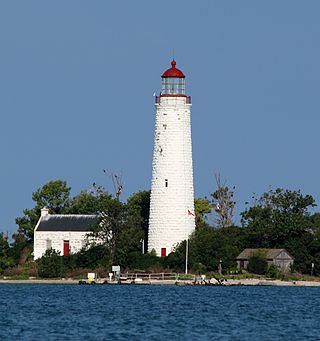
The Cove Island Light, at Gig Point on the island, is located in Fathom Five National Marine Park, but is not part of the Park. It is situated on the Bruce Peninsula, Ontario Canada. It has been a navigational aid in the narrow channel between Lake Huron and Georgian Bay since 30 October 1858. It was the first of six stone Imperial Towers to be completed; all were illuminated by 1859. Most other lighthouses of the era were built of brick, wood, iron or concrete.

Marshall Point Light Station is a lighthouse at the entrance of Port Clyde Harbor in Port Clyde, Maine. The light station was established in 1832.
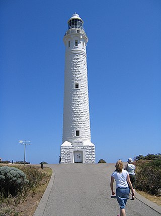
The Cape Leeuwin Lighthouse is a lighthouse located on the headland of Cape Leeuwin, the most south-westerly point on the mainland of the Australian Continent, in the state of Western Australia.

Cape Bowling Green Light is an active lighthouse on Cape Bowling Green, a long headland ending in a long low sandspit, about 30 kilometres (19 mi) from Ayr, Queensland, Australia. The lighthouse is at the end of the headland, near the base of the sandspit. The first lighthouse at the location, established in 1874, was moved multiple times. It was prefabricated in Brisbane, shipped to the location, moved twice due to coastal erosion and finally transferred for display at the Australian National Maritime Museum at Darling Harbour in Sydney.

Low Point Lighthouse is an historic Canadian lighthouse marking the eastern entrance to Sydney Harbour at New Victoria, Nova Scotia, near New Waterford, Nova Scotia. This is one of the earliest and most important light stations of Nova Scotia, one of the first dozen beacons in Nova Scotia to be lit to guide mariners, a classic red-and-white lighthouse still operated by the Canadian Coast Guard.

Cape Race Lighthouse is an active lighthouse located at Cape Race on the Avalon Peninsula, Newfoundland. The light's characteristic is a single white flash every 7.5 seconds; additionally, a foghorn may sound a signal of two blasts every 60 seconds. It is located on one of Canada's busiest shipping lanes. The lighthouse is also a tourist attraction.

Lowestoft Lighthouse is a lighthouse operated by Trinity House located to the north of the centre of Lowestoft in the English county of Suffolk. It stands on the North Sea coast close to Ness Point, the most easterly point in the United Kingdom. It acts as a warning light for shipping passing along the east coast and is the most easterly lighthouse in the UK.

Kincardine is a community and former town, located in the municipality of Kincardine on the shores of Lake Huron in Bruce County in the province of Ontario, Canada. The namesake town is located at the mouth of the Penetangore River, and was founded in 1848 by the name of Penetangore. The current municipality was created in 1999 by the amalgamation of the Town of Kincardine, the Township of Kincardine, and the Township of Bruce. The former town is Ward 1 within the current municipal boundaries.
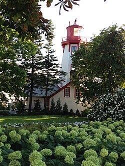
The Chantry Island Lighthouse, officially known as Chantry Island Lightstation Tower, is a lightstation on Chantry Island, off the coast of Southampton, Ontario in Lake Huron. It was constructed in the years 1855 through to 1859, by John Brown of Thorold, Ontario, under the authority of the Province of Canada and is recognized as one of the six Imperial Towers. Virtually identical, they were completed in 1858-1859 on Lake Huron and Georgian Bay and are among the few lighthouses on the Great Lakes made of cut limestone and granite.
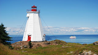
The Swallowtail Lighthouse is a Canadian lighthouse located on Grand Manan Island in the Bay of Fundy. It was the first lighthouse to be built on the island. It was first lit on 7 July 1860 and was automated and de-staffed in 1986.

Big Tub Lighthouse is an active lighthouse located near Tobermory in Bruce Peninsula, Ontario, Canada. The lighthouse was originally lit in 1885 and is still used up to this day.