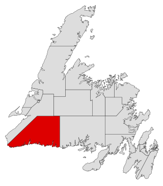
Burgeo-La Poile is a provincial electoral district for the House of Assembly of Newfoundland and Labrador, Canada. As of 2011, there are 7,527 eligible voters living within the district. The district was first created when Newfoundland joined confederation in 1949 as Burgeo and La Poile, and existed until 1975. It was recreated in 1995 following a reduction in the number of seats in the House of Assembly from 52 to 48, forming from the amalgamation of the former districts of La Poile and Burgeo-Bay D'Espoir.
Cape Ray is a local service district and designated place in the Canadian province of Newfoundland and Labrador. It is on the southwest coast of the island of Newfoundland.
Cape Norman is a barren, limestone headland located at the northernmost point of insular Newfoundland in the Canadian province of Newfoundland and Labrador.
Cape Bauld is a headland located at the northernmost point of Quirpon Island, an island just northeast of the Great Northern Peninsula of Newfoundland in the Canadian province of Newfoundland and Labrador.
Bacalieu Island is an island off Twillingate in Newfoundland. It has a lighthouse. In 1911, it was inhabited by the lighthouse keepers and their families.
Garnish, a town located on the west coast of the Burin Peninsula, was well known for its lumbering and now for its lobstering operations. Located on Route 213, it is 25 km along route 220 north west of Grand Bank and 18 km along Route 220 east of Marystown. The Way Office was established in 1852 and the first Waymaster was Henry Campe. In 2021, the town had a population of 542.

Point Escuminac is a cape located in eastern New Brunswick, Canada. Its geographic coordinates are 47º04'N, 64º48'W.

Lark Harbour is small fishing community on the western coast of Newfoundland, on the south side of the Bay of Islands, and west of the City of Corner Brook.
Cape Bonavista is a headland located on the east coast of the island of Newfoundland in the Canadian province of Newfoundland and Labrador. It is located at the northeastern tip of the Bonavista Peninsula, which separates Trinity Bay to the south from Bonavista Bay to the north. The nearby town of Bonavista takes its name from this historic landmark.

Fort Amherst is a neighbourhood in St. John's, Newfoundland and Labrador. It is located at 47°33′48.96″N52°40′49.60″W, on the southern side of the Narrows, the entrance to St. John's harbour. Apart from some family dwellings, Fort Amherst consists of a man-made harbour, a lighthouse and the remains of gun emplacements built during World War II to defend against German U-boats. Two QF 4.7-inch B Mark IV* guns remain in place on their mountings.

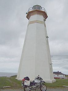
Cape Anguille is a headland and the westernmost point in Newfoundland, reaching into the Gulf of Saint Lawrence. It is the southern edge of St. George's Bay. Its name is derived from the French word anguille, which means eel. Close to the cape is the community of Cape Anguille.
Westport is a town in the Canadian province of Newfoundland and Labrador. The town had a population of 185 in 2021, down from 195 in the Canada 2016 Census.

The headland of Cape St. Francis is the outer extremity marking the boundary of Conception Bay on the Avalon Peninsula of the island of Newfoundland in the Canadian province of Newfoundland and Labrador. The International Maritime Organization also designates Cape St. Francis as the southern extremity of the Labrador Sea.

The headland of Cape St. Mary's is located at the southern tip of the south-western arm of the Avalon Peninsula of the island of Newfoundland in the Canadian province of Newfoundland and Labrador.

Long Point Lighthouse is an active Canadian lighthouse located outside Crow Head on North Twillingate Island off the northeast coast of Newfoundland. The lighthouse, completed in 1876, attracts thousands of tourists each year and is historic to the town of Twillingate.

Lobster Cove is a fishing village near Rocky Harbour, Newfoundland.
Pushthrough is a resettled fishing community located on Newfoundland and Labrador's south coast, about 20 km northwest of Hermitage. Permanent settlement at Pushthrough happened in 1814, when George Chambers moved there from Gaultois to establish a fishing room and later a store. The community lost population to Gaultois in the 1950s and to Head of Bay d'Espoir in the 1960s. In 1968, virtually all the families with school aged children moved, effectively leading to the downfall of the community.
Fox Point is a settlement in Newfoundland and Labrador.
Division No. 1, Subdivision B is an unorganized subdivision on the Avalon Peninsula in Newfoundland and Labrador, Canada. It is in Division 1 and contains the unorganized communities of Iona, Little Barasway, Placentia Junction, Point Verde and Ship Harbour.