Campbell River is a city in British Columbia, Canada, on the east coast of Vancouver Island at the south end of Discovery Passage, which lies along the 50th parallel north along the important Inside Passage shipping route. Campbell River has a population of 32,588 and has long been touted as the "salmon capital of the world." Campbell River and Region are near the communities of Quadra and the Discovery Islands, Sayward, Oyster River, Gold River, Tahsis and Zeballos.

Race Rocks Light is one of the first two lighthouses that were built on the west coast of Canada, financed by the British Government and illuminated in 1860. It is the only lighthouse on that coast built of rock, (granite) purportedly quarried in Scotland, and topped with sandstone quarried on Gabriola Island. The Islands of Race Rocks are located just off the southern tip of Vancouver Island, about 16 km (10 mi) southwest of Victoria, British Columbia.

Quadra Island is a large island off the eastern coast of Vancouver Island, in British Columbia, Canada. It is part of the Discovery Islands, in the Strathcona Regional District.

Cape Beale Lightstation is an active manned lighthouse on Vancouver Island in British Columbia, Canada.

HMS Discovery was a Royal Navy ship launched in 1789 and best known as the lead ship in George Vancouver's exploration of the west coast of North America in his famous 1791-1795 expedition. She was converted to a bomb vessel in 1798 and participated in the Battle of Copenhagen. Thereafter she served as a hospital ship and later as a prison hulk until 1831. She was broken up in 1834.

Masset is a village in the Haida Gwaii archipelago in British Columbia, Canada. It is located on Masset Sound on the northern coast of Graham Island, the largest island in the archipelago, and is approximately 50 km (31 mi) west of mainland British Columbia. It is the primary western terminus of Trans-Canada Highway 16 and is served by Masset Airport, with flights to Vancouver and Prince Rupert. During the maritime fur trade of the early 19th century, Masset was a key trading site. It was incorporated as a village municipality on May 11, 1961.
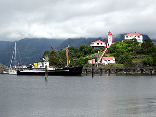
Yuquot, also known as Friendly Cove, is a small settlement of around six people—the Williams family of the Mowachaht band—plus two full-time lighthouse keepers, located on Nootka Island in Nootka Sound, just west of Vancouver Island, British Columbia, Canada. It was the summer home of Chief Maquinna and the Mowachaht/Muchalaht (Nuu-chah-nulth) people for generations, housing approximately 1,500 people in 20 traditional wooden longhouses. The name means "Wind comes from all directions" in Nuu-chah-nulth.
Menzies Bay is a large bay adjoining Seymour Narrows and Quadra Island north of Campbell River on Vancouver Island. It was once considered in 1872 as a crossing point to Vancouver Island for the Canadian Pacific Railway from Sonora Island and Bute Inlet in that project's quest for a transcontinental line. The bay was the site of a Bloedel, Stewart and Welch railroad logging camp in the 1930s, and adjacent to Ripple Rock.

De Courcy Island is one of the Gulf Islands of the coast of southwestern British Columbia, Canada, located between the Pylades and Stuart Channels approximately 16 km (9.9 mi) southeast of Nanaimo and approximately 38 km (24 mi) west of Vancouver.

Cortes Island is an island in the Discovery Islands archipelago on the coast of British Columbia, Canada. The island is 25 km (16 mi) long, 13 km (8 mi) wide, and 130 km2 (50 sq mi) in area. It has a population of 1,035 permanent residents. Cortes Island lies within Electoral Area B of the Strathcona Regional District, which provides water and sewage systems, fire protection, land use planning, parks, recreation, and emergency response.

Fisgard Lighthouse National Historic Site, on Fisgard Island at the mouth of Esquimalt Harbour in Colwood, British Columbia, is the site of Fisgard Lighthouse, the first lighthouse on the west coast of Canada.

Sheringham Point Lighthouse is located on Vancouver Island, British Columbia, near the community of Shirley. Built in 1912 following the fatal wreck of the SS Valencia six years earlier, it is still used for navigation. The point was named for William L. Sheringham who took part in various naval surveys although not in this area.

Discovery Passage is a strait that forms part of the Inside Passage between Vancouver Island and the Discovery Islands of British Columbia. The strait is considered the most important natural passage for vessels' entering or leaving the Salish Sea from the north.

The Vancouver Expedition (1791–1795) was a four-and-a-half-year voyage of exploration and diplomacy, commanded by Captain George Vancouver of the Royal Navy. The British expedition circumnavigated the globe and made contact with five continents. The expedition at various times included between two and four vessels, and up to 153 men, all but 6 of whom returned home safely.

Milbanke Sound is a sound on the coast of the Canadian province of British Columbia.
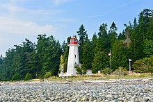
The We Wai Kai Nation, also known as the Wewaikai First Nation, the Cape Mudge First Nation and the Cape Mudge Indian Band, is the band government of the We Wai Kai subgroup of the Laich-kwil-tach group of the Kwakwaka'wakw peoples, based on Quadra Island offshore from Campbell River, British Columbia, Canada, which is on the east coast of Vancouver Island at the northern end of the Strait of Georgia. The Laich-kwil-tach include the Wei Wai Kum, who are organized as the Campbell River First Nation, and the Kwiakah Nation, whose traditional territory is in the Discovery Islands to the northeast of that city and on the adjoining mainland coast. All three are part of the Kwakiutl District Council, a tribal council which includes other Kwakwaka'wakw bands farther northwest in the Queen Charlotte Strait region and on northern Vancouver Island.

Carmanah Point Light Station is a lighthouse on the southwest coast of Vancouver Island at the entrance from the Pacific Ocean to the Strait of Juan de Fuca.

John Thomas Walbran was an English-Canadian ship's master and writer.

Triple Island Lighthouse is a large, manned light station on Triple Island. Built in 1920 after four years of construction, the concrete station features a 21.9 metres (72 ft) tower attached to a rectangular concrete structure that houses the keepers' quarters and machinery. A Triple Island helipad occupies much of the remainder of the islet. Canadian Coast Guard personnel man the station on a 28-day rotation. The station was designated a National Historic Site of Canada in 1974.
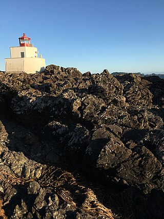
Amphitrite Point Lighthouse is an active lighthouse in Ucluelet on the west coast of Vancouver Island in British Columbia, Canada, named after Amphitrite, the sea goddess and wife of Poseidon in Greek mythology. It is also known for one of the sample pictures in Windows 7.