Devils Island Light (Nova Scotia)

Last updated
Devils Island East Light
Lighthouse DGJ 7383 - Devils Island Lighthouse (6230998678).jpg
Devils Island in 2010
Devils Island Light (Nova Scotia)
Location Devils Island
Nova Scotia
Canada
Coordinates 44°34′51.4″N63°27′30.5″W / 44.580944°N 63.458472°W / 44.580944; -63.458472 Coordinates: 44°34′51.4″N63°27′30.5″W / 44.580944°N 63.458472°W / 44.580944; -63.458472
Tower
Constructionwooden tower
Automated1978
Height39 feet (12 m)
Shapeoctagonal tower with balcony, lantern removed in 1978
Markingswhite tower
OperatorCanadian Coast Guard [1] [2]
Light
First lit1852
Focal height52 feet (16 m)
Range13 nautical miles (24 km; 15 mi)
Characteristic Fl W 10s.

The Devils Island Light is a Nova Scotia lighthouse located at the eastern shore entrance to Halifax Harbour on Devils Island, Nova Scotia. First lit in 1852, it was succeeded by a second lighthouse in 1877 which survives today. The lighthouse has influenced regional folklore and remains an important community landmark although it is currently neglected and threatened.

Contents

History

In 1711, a map of Halifax harbour was designed by a French engineer De Labat and featured a thirty-seven acre island named "Isle Verte" or Green Island after all the trees. Rear Admiral Pullen records that on James Cook's charts in 1759 the island is called Devils Island, but on Thomas Backhouse's chart of "The Harbour of Halifax," 1798, it is called Devils or Rous's Island. According to H. W. Hewitt, a schoolteacher and author of numerous articles on the history of Eastern Passage, a group of Halifax sportsmen went to the island for a night and ended up staying a few days longer than planned after an episode of bad weather. After returning to dry land, when asked where they had been, they all replied that they "did not know unless it was the Devil's Island". But this is just one of the stories that accounts for the origin of the name; like many islands, its name has undergone a few changes through history.

Devils Island, situated in the Atlantic Ocean – amid shoals and other hazards for seafarers, was the cause of numerous shipwrecks. The residents often used their own fishing boats and risked their lives in attempts to rescue the crews of wrecked ships. In 1837, a wooden beacon painted white was erected on the southern point of the island as a navigational aid, but because it was only visible during the day time, in 1851 a Halifax group made up of merchants, traders, and sea mariners presented a petition to the lieutenant-governor for a lighthouse to be built which the Assembly approved. In 1852, an octagonal lighthouse with an accompanying mirrored light was constructed near the shore on the southwest corner of the island. In 1877, a second lighthouse was built 175 yards east of the first one. The western light "was open all round, while the eastern one was dark on its northern side" (Boileau, Historic Eastern Passage, 103). Both white lights were visible from a distance of thirteen miles. In 1949, the first lighthouse erected was demolished and the light in the second was changed to flashing red and was visible for thirteen miles. In 1959, it was changed to a flashing white and amber light and was visible for eleven miles. In 1967, an automatic beacon flashing white was installed making the lighthouse keeper unnecessary, and all permanent human habitation on the island ceased after this event. Devils Island has been deserted for many years now and the remaining standing buildings, like the lighthouse keeper's house, have been exposed to yearly seasonal weather without any maintenance and show signs of great disrepair. While under the care of the Canadian Coast Guard, the cupola of this second lighthouse was dismantled and discarded on the beach.

Cultural Significance

Devils Island and its lighthouse have artistic and a cultural significance as the source of stories and songs of the sea. In 1928 Helen Creighton first heard folk stories with the motif of a sunken crew taking over a ship from the singing of Gordon Young on Devils Island : "A dozen dripping sailors...faces pale and wan moved before us till...the lighthouse shone its light" (Creighton, Bluenose Ghosts, 117).

Families in nearby Eastern Passage have a deep attachment which is especially felt by the many descendants of the families who were once residents of Devils Island and who now live in Eastern Passage and share a living connection to the history of this island as well as a vivid view plane of this iconic structure against sky and sea. Many Eastern Passage residents and descendants of Devils Island long to see a lighted tower on the island again.

Devils Island Light Society

In 2009, a group of private citizens formed the Devils Island Light Society to express concern for the present condition and also the future of the lighthouse. It was the intention of the society to apply to have the Devils Island lighthouse included under Bill S-215 (the Heritage Lighthouse Protection Act) when the Bill came into force in May 2010. The Canadian Heritage Act designates and preserves historically significant lighthouses. It also requires that communities near the lights be consulted before changing, selling, transferring or demolishing any of the designated stations. The society fought an uphill battle against Coast Guard censure and warning that members were not allowed to approach the lighthouse to restore and paint the facade. Nevertheless, the society mounted a rigorous campaign to publicize the historical and cultural significance of this seafaring landmark and organized a petition to demonstrate public support for its mission to save the lighthouse and maintain it on the Island, in situ. Approximately 8,000 signatures were collected and presented to the federal committee having oversight of Canadian lighthouses.

See also

Notes

  1. Rowlett, Russ. "Lighthouses of Canada: Eastern Nova Scotia". The Lighthouse Directory. University of North Carolina at Chapel Hill . Retrieved 2016-08-09.
  2. Devil's Island Light (NS) Lighthouse Explorer. Retrieved 9 August 2016

Related Research Articles

<span class="mw-page-title-main">Lunenburg, Nova Scotia</span> Coastal town and UNESCO World Heritage Site in Nova Scotia, Canada

Lunenburg is a port town on the South Shore of Nova Scotia, Canada. Founded in 1753, the town was one of the first British attempts to settle Protestants in Nova Scotia.

<span class="mw-page-title-main">Eastern Passage, Nova Scotia</span> Community in Nova Scotia, Canada

Eastern Passage is an unincorporated suburban community in Halifax Regional Municipality Nova Scotia, Canada.

<span class="mw-page-title-main">Halifax Harbour</span> Harbour in Nova Scotia, Canada

Halifax Harbour is a large natural harbour on the Atlantic coast of Nova Scotia, Canada, located in the Halifax Regional Municipality. Halifax largely owes its existence to the harbour, being one of the largest and deepest ice-free natural harbours in the world. Before Confederation it was one of the most important commercial ports on the Atlantic seaboard. In 1917, it was the site of the world's largest man-made accidental explosion, when the SS Mont-Blanc blew up in the Halifax Explosion of December 6.

<i>Theodore Tugboat</i> Children’s television series

Theodore Tugboat is a Canadian children's television series about a tugboat named Theodore who lives in the Big Harbour with all of his friends. The show originated in Halifax, Nova Scotia, Canada as a co-production between the CBC, and the now defunct Cochran Entertainment, and was filmed on a model set using radio controlled tugboats, ships, and machinery. Production of the show ended in 2001, and its distribution rights were later sold to Classic Media. The show premiered in Canada on CBC Television, then went to PBS, was on Qubo in the United States, and has appeared in eighty different countries.

<span class="mw-page-title-main">Georges Island (Nova Scotia)</span>

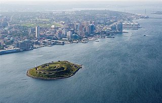
Georges Island is a glacial drumlin and the largest island entirely within the harbour limits of Halifax Harbour located in Nova Scotia's Halifax Regional Municipality. The Island is the location of Fort Charlotte - named after King George's wife Charlotte. Fort Charlotte was built during Father Le Loutre's War, a year after Citadel Hill. The island is now a National Historic Site of Canada. As of August 6, 2020, the island is open to the public on the weekends, from June until Thanksgiving weekend.

<span class="mw-page-title-main">McNabs Island</span> Island in Halifax Harbour in Nova Scotia, Canada

McNabs Island is the largest island in Halifax Harbour located in Halifax Regional Municipality, Nova Scotia, Canada. It played a major role in defending Halifax Harbour and is now a provincial park. The island was settled by Britons in the 1750s and later by Peter McNab, and McNab family members lived on the island until 1934.

<span class="mw-page-title-main">Helen Creighton</span>

Mary Helen Creighton, CM was a prominent Canadian folklorist. She collected over 4,000 traditional songs, stories, and beliefs in a career that spanned several decades, and she published many books and articles on Nova Scotia folk songs and folklore. She received numerous honorary degrees for her work and was made a Member of the Order of Canada in 1976.

<span class="mw-page-title-main">Geography of Nova Scotia</span>

Nova Scotia is a province located in Eastern Canada fronting the Atlantic Ocean. One of the Maritime Provinces, Nova Scotia's geography is complex, despite its relatively small size in comparison to other Canadian provinces.

<span class="mw-page-title-main">Sambro Island Light</span> Lighthouse

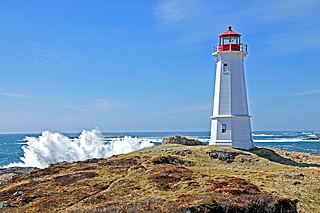
Sambro Island Lighthouse is a landfall lighthouse located at the entrance to Halifax Harbour, Nova Scotia, on an island near the community of Sambro in the Halifax Regional Municipality. It is the oldest surviving lighthouse in North America and its construction is a National Historic Event.

<span class="mw-page-title-main">Devils Island (Nova Scotia)</span> Island community in Nova Scotia, Canada

Devils Island, Nova Scotia is located on the northeast entrance of Halifax Harbour part of the Halifax Regional Municipality off the coast of the community of Eastern Passage, Nova Scotia. The name originated from an early French merchant and was first spelled Deville's Island. The first permanent settlement on this 12-hectare (30-acre) island was established in 1830, and by 1850 there were three houses and a school. By 1901 the settlement had grown to 18 houses. A number of Devil's Island residents, notably Ben Henneberry, provided valuable folklore to pioneering Canadian folklorist Helen Creighton. Most of the residents were moved to the mainland during World War II. The last permanent resident, a Norwegian artist, moved off in 2000. The island is currently owned by Halifax entrepreneur Bill Mont. The Devil's Island Lighthouse built in 1877, replacing an earlier tower built in 1852, is still standing but is not functional and is threatened. The island was also the base for a rescue lifeboat until the 1950s which saved the crews of many vessels stranded on the shoals approaching Halifax Harbour.

<span class="mw-page-title-main">Louisbourg Lighthouse</span> Lighthouse

Louisbourg Lighthouse is an active Canadian lighthouse in Louisbourg, Nova Scotia. The current tower is the fourth in a series of lighthouses that have been built on the site, the earliest was the first lighthouse in Canada.

<span class="mw-page-title-main">Wood Islands Lighthouse</span> Lighthouse

The Wood Islands Lighthouse is a historic lighthouse built by Joseph Tomlinson situated on the southeastern shore of Prince Edward Island, located in the community of Wood Islands. The lighthouse is a well-preserved three storey tower with an adjoining 1+12-storey keeper's residence. The white shingled tower is topped by a red iron lantern, which is enclosed by a white railing on the observation deck. The red roof of the dwelling provides a striking contrast to the white shingled exterior of the dwelling.

The history of lighthouses in Canada dates back to 1734.

Evelyn M. Richardson, born Evelyn May Fox (1902–1976) was a Canadian writer who won the Governor General's Award in non-fiction for her 1945 memoir, We Keep a Light. The annual Evelyn Richardson Memorial Literary Award is given in her honour to a Nova Scotia writer of non-fiction.

<span class="mw-page-title-main">Low Point Lighthouse</span> Lighthouse

Low Point Lighthouse is an historic Canadian lighthouse marking the eastern entrance to Sydney Harbour at New Victoria, Nova Scotia, near New Waterford, Nova Scotia. This is one of the earliest and most important light stations of Nova Scotia, one of the first dozen beacons in Nova Scotia to be lit to guide mariners, a classic red-and-white lighthouse still operated by the Canadian Coast Guard.

<i>Bluenose Ghosts</i>

Bluenose Ghosts is a book which presents a series of Nova Scotia ghost stories collected by Canadian folklorist Helen Creighton over a period of 28 years, first published in 1957.

<span class="mw-page-title-main">Cape d'Or</span> Lighthouse

Cape d'Or is a headland located near Advocate, Cumberland County, on the Bay of Fundy coast of the Canadian province of Nova Scotia.

<span class="mw-page-title-main">Outline of Nova Scotia</span> Overview of and topical guide to Nova Scotia

The following outline is provided as an overview of and topical guide to Nova Scotia:

<span class="mw-page-title-main">Balache Point Lighthouse</span> Lighthouse in Nova Scotia, Canada

Balache Point Lighthouse also known as Balache Point Range Rear Lighthouse is an active Canadian lighthouse located next to the Canso Canal, near Port Hastings, Inverness County, Nova Scotia. The salt shaker style light, which sits on a small hillock on the Cape Breton side of the canal, is the second lighthouse to be built on the site.

<span class="mw-page-title-main">Grandique Point Lighthouse</span> Lighthouse

Grandique Point Lighthouse is an aid to navigation for Lennox Passage, which is the channel of water between the southern shore of Cape Breton Island and Isle Madame, Nova Scotia, Canada. The lighthouse is located on the beach at Grandique Point in Lennox Passage Provincial Park and is accessible by a gravel road within the provincial park. The site is open to the public, the tower is closed.

References