Beaver Harbour, New Brunswick

Last updated

Beaver Harbour
Beaver Harbour 1920 maisons.jpg
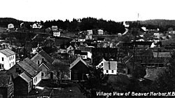
Beaver Harbour in 1920
Canada New Brunswick location map 2.svg
Red pog.svg
Beaver Harbour
Location within New Brunswick.
Coordinates: 45°04′23″N66°44′34″W / 45.07306°N 66.74278°W / 45.07306; -66.74278 Coordinates: 45°04′23″N66°44′34″W / 45.07306°N 66.74278°W / 45.07306; -66.74278
CountryFlag of Canada (Pantone).svg  Canada
ProvinceFlag of New Brunswick.svg  New Brunswick
County Charlotte
Electoral Districts
Federal

New Brunswick Southwest
Provincial Charlotte-The Isles
Area
  Total2.25 km2 (0.87 sq mi)
Population
 (2021) [1]
  Total291
  Density129.3/km2 (335/sq mi)
  Pop 2016-2021
Increase2.svg 5.1%
  Dwellings
142
Time zone UTC-4 (AST)
  Summer (DST) UTC-3 (ADT)
Postal code(s)
E5H
Area code 506
HighwaysNB 778.svg Route 778

Beaver Harbour is a community on the Fundy shore of New Brunswick, Canada.

Most of the community forms the Local service district of Beaver Harbour, which was established in 1971. [2] It is also a census subdivision of Census Canada. Since the formation of the LSD, the community has expanded past the original boundaries into the LSD of the parish of Pennfield.[ citation needed ]

In 1866 it had about 30 resident families, and grew to a population of 150 by 1871, the 500 in 1898. [3] As of 2021, the population was 291. [1]

It is the site of the Lighthouse Point Light, originally built in 1875 and subsequently rebuilt. It is a fiberglass tapered cylindrical tower with balcony and lantern. [4]

History

Beaver Harbour was first settled in 1783 by Quaker loyalists who had fled Pennsylvania as a result of the American Revolution. It became the first settlement in British North America to forbid slavery, with 49 names of families being attached to a founding constitution which barred slave owners from living there. [5] [6]

Related Research Articles

<span class="mw-page-title-main">Grand Manan</span> Village in New Brunswick, Canada

Grand Manan is a Canadian island in the Bay of Fundy, part of the province of New Brunswick. Grand Manan is also the name of an incorporated village, which includes the main island and numerous nearby islands; White Head Island, small islands near it, and Machias Seal Island are not part of the village.

<span class="mw-page-title-main">Campobello Island</span> Island in Campobello, New Brunswick, Canada

Campobello Island is the largest and only inhabited island in Campobello, a civil parish in southwestern New Brunswick, Canada, near the border with Maine, United States. The island's permanent population in 2021 was 949. It is the site of the Roosevelt Campobello International Park and of Herring Cove Provincial Park.

<span class="mw-page-title-main">Gagetown, New Brunswick</span> Unincorporated community in New Brunswick, Canada

Gagetown is a community in Queens County, New Brunswick, Canada. It held village status prior to 2023. It is on the west bank of the Saint John River and is the county's shire town.

<span class="mw-page-title-main">Saint Andrews, New Brunswick</span> Town in New Brunswick, Canada

Saint Andrews is a town in Charlotte County, New Brunswick, Canada. The historic town is a national historic site of Canada, bearing many characteristics of a typical 18th century British colonial settlement, including the original grid layout with its market square, and the classical architecture.

Blacks Harbour is a community in the incorporated rural community of Eastern Charlotte, New Brunswick, Canada. It held village status prior to 2023. It is on a harbour of the same name opening onto the Bay of Fundy. It is 15 kilometres southeast of the town of St. George, 3 kilometres west of Beaver Harbour and 56 kilometres east from the town of St. Stephen on Route 176.

<span class="mw-page-title-main">St. Martins, New Brunswick</span> Unincorporated community in New Brunswick, Canada

St. Martins is a community on the Bay of Fundy in Saint John County, New Brunswick, Canada.

<span class="mw-page-title-main">Reefs Harbour-Shoal Cove West-New Ferolle</span> Lighthouse

Reefs Harbour-Shoal Cove West-New Ferolle is a local service district and designated place in the Canadian province of Newfoundland and Labrador. It is southwest of Anchor Point.

<span class="mw-page-title-main">Cocagne</span> Place in New Brunswick, Canada

Cocagne is a Canadian community, formerly part of an eponymous local service district (LSD) and later incorporated rural community, in Kent County, New Brunswick.

<span class="mw-page-title-main">Dalhousie Parish, New Brunswick</span> Parish in New Brunswick, Canada

Dalhousie is a civil parish in Restigouche County, New Brunswick, Canada.

<span class="mw-page-title-main">Bathurst Parish, New Brunswick</span> Parish in New Brunswick, Canada

Bathurst is a civil parish in Gloucester County, New Brunswick, Canada.

<span class="mw-page-title-main">Caraquet Parish, New Brunswick</span> Parish in New Brunswick, Canada

Caraquet is a civil parish in Gloucester County, New Brunswick, Canada.

<span class="mw-page-title-main">Shippegan Parish, New Brunswick</span> Parish in New Brunswick, Canada

Shippegan is a civil parish in Gloucester County, New Brunswick, Canada. Located in the northeastern corner of the province at the end of the Acadian Peninsula, the parish consists of the three main islands of Taylor, Lamèque, and Miscou, along with several smaller islands and tidal wetlands; Taylor Island is now joined to the mainland by an isthmus, which is crossed by a causeway.

<span class="mw-page-title-main">Wakefield Parish, New Brunswick</span> Parish in New Brunswick, Canada

Wakefield is a civil parish in Carleton County, New Brunswick, Canada, located north on the west bank of the Saint John River north of Woodstock.

<span class="mw-page-title-main">Caraquet</span> Town in New Brunswick, Canada

Caraquet is a town in Gloucester County, New Brunswick, Canada.

<span class="mw-page-title-main">Grand-Bouctouche</span> Place in New Brunswick, Canada

Grand-Bouctouche is a Canadian town in Kent County, New Brunswick.

<span class="mw-page-title-main">Lepreau Parish, New Brunswick</span> Parish in Canada

Lepreau is a civil parish in Charlotte County, New Brunswick, Canada, west of Saint John.

<span class="mw-page-title-main">Pennfield Parish, New Brunswick</span> Parish in Canada

Pennfield is a civil parish in Charlotte County, New Brunswick, Canada, located west of Saint John located east of St. George and west of Saint John.

<span class="mw-page-title-main">West Isles Parish, New Brunswick</span> Parish in Canada

West Isles is a civil parish in Charlotte County, New Brunswick, Canada.

<span class="mw-page-title-main">Saint George Parish, New Brunswick</span> Parish in Canada

Saint George is a civil parish in Charlotte County, New Brunswick, Canada, located between St. Stephen and Saint John.

<span class="mw-page-title-main">Grand Manan Parish, New Brunswick</span> Parish in Canada

Grand Manan is a civil parish in Charlotte County, New Brunswick, Canada, comprising one village and one local service district (LSD), both of which are members of the Southwest New Brunswick Service Commission (SNBSC). The parish includes Grand Manan Island and numerous lesser islands, only one of which has permanent year-round inhabitants.

References

  1. 1 2 Government of Canada, Statistics Canada (9 February 2022). "Profile table, Census Profile, 2021 Census of Population - Beaver Harbour, Local service district (LSD) [Designated place], New Brunswick". www12.statcan.gc.ca.
  2. "Regulation 71-17 under the Municipalities Act (O. C. 71-127)". The Royal Gazette. Fredericton, NB, Canada. 129: 154. 3 March 1971. Filed February 17, 1971.
  3. "Beaver Harbour". Provincial Archives of New Brunswick. Retrieved 22 June 2020.
  4. "Lighthouse Point Lighthouse". LighthouseFriends. Retrieved 22 June 2020.
  5. "N.B. community first in British North America to forbid slavery". Atlantic. 26 February 2015.
  6. "Beaver Harbour" (PDF). Heritage Charlotte.