Blacks Harbour, New Brunswick

Last updated

Blacks Harbour
Canada New Brunswick location map 2.svg
Red pog.svg
Blacks Harbour
Location within New Brunswick.
Coordinates: 45°03′32″N66°47′05″W / 45.05889°N 66.78472°W / 45.05889; -66.78472
CountryCanada
Province New Brunswick
County Charlotte
Municipality Eastern Charlotte
Incorporated1972
Amalgamated1 January 2023
Area
[1]
  Total9.02 km2 (3.48 sq mi)
Population
 (2021) [1]
  Total907
  Density100.6/km2 (261/sq mi)
  Pop 2016-2021
Increase2.svg 1.5
  Dwellings
421
Time zone UTC-4 (AST)
  Summer (DST) UTC-3 (ADT)
Postal code(s)
E5H
Area code 506
Highways
NB 176.svg Route 176

NB 778.svg Route 778
Website www.blacksharbour.ca/ home_page.html

Blacks Harbour is a community in the rural community of Eastern Charlotte, New Brunswick, Canada. It held village status prior to 2023. It is on a harbour of the same name opening onto the Bay of Fundy. It is 15 kilometres southeast of the town of St. George, 3 kilometres west of Beaver Harbour and 56 kilometres east from the town of St. Stephen on Route 176.

Contents

History

Blacks Harbour's exact origin is unknown, possibly an early family name. Post office dates from 1889. [2]

On 1 January 2023, Blacks Harbour amalgamated with St. George and all or part of five local service districts to form the new incorporated rural community of Eastern Charlotte. [3] [4] The name Blacks Harbour remains in official use. [5]

Geography

Vehicles boarding the ferry in Blacks Harbour to Grand Manan Island (2002) Black's Harbour (3750624650).jpg
Vehicles boarding the ferry in Blacks Harbour to Grand Manan Island (2002)

Blacks Harbour is the northern terminus for the year-round Blacks Harbour to Grand Manan Island Ferry operated by Coastal Transport

Fishing has been a vital part of its existence for over 200 years. Connors Brothers Limited was founded in 1885 at Blacks Harbour, now a major international processor of all types of seafood. The company is also a major New Brunswick employer.

Demographics

Historical Census Data - Blacks Harbour, New Brunswick [6]
YearPop.±%
1991 1,139    
1996 1,148+0.8%
2001 1,082−5.7%
2006 952−12.0%
2011 982+3.2%
2016 894−9.0%
2021 907+1.5%
Source: [1]

In the 2021 Census of Population conducted by Statistics Canada, Blacks Harbour had a population of 907 living in 385 of its 421 total private dwellings, a change of 1.5% from its 2016 population of 894. With a land area of 9.02 km2 (3.48 sq mi), it had a population density of 100.6/km2 (260.4/sq mi) in 2021. [1]

Canada census – Blacks Harbour community profile
2021 2011
Population907 (+1.5% from 2016)982 (+3.2% from 2006)
Land area9.02 km2 (3.48 sq mi)8.90 km2 (3.44 sq mi)
Population density100.6/km2 (261/sq mi)110.3/km2 (286/sq mi)
Median age45.6 (M: 44.4, F: 46.8)42.5 (M: 40.2, F: 45.0)
Private dwellings421 (total)  385 (occupied)417 (total) 
Median household income$60,000$43,367
References: 2021 [7] 2011 [8] earlier [9] [10]

Language

Canada Census Mother Tongue - Blacks Harbour, New Brunswick [6]
CensusTotal
English
French
English & French
Other
YearResponsesCountTrendPop %CountTrendPop %CountTrendPop %CountTrendPop %
2011
950
850Increase2.svg 1.8%89.47%65Decrease2.svg 18.7%6.84%5Increase2.svg n/a%0.53%30Increase2.svg 100.0%3.16%
2006
930
835Decrease2.svg 13.5%89.79%80Decrease2.svg 20.0%8.60%0Steady2.svg 0.0%0.00%15Increase2.svg n/a%1.61%
2001
1,065
965Decrease2.svg 1.0%90.61%100Decrease2.svg 4.8%9.39%0Decrease2.svg 100.0%0.00%0Decrease2.svg 100.0%0.00%
1996
1,135
975n/a85.90%105n/a9.25%10n/a0.88%45n/a3.96%

Related Research Articles

<span class="mw-page-title-main">Albert County, New Brunswick</span> County in New Brunswick, Canada

Albert County is New Brunswick's third-youngest county located on the Western side of the Petitcodiac River on the Chignecto Bay in the Bay of Fundy. Prior to the abolition of county government in 1967, the shire town was Hopewell Cape. The county was established in 1845 from parts of Westmorland County and Saint John County, and named after Prince Albert.

<span class="mw-page-title-main">Charlotte County, New Brunswick</span> County in New Brunswick, Canada

Charlotte County is the southwest-most county of New Brunswick, Canada.

<span class="mw-page-title-main">Campobello Island</span> Island in Campobello, New Brunswick, Canada

Campobello Island is the largest and only inhabited island in Campobello, a civil parish in southwestern New Brunswick, Canada, near the border with Maine, United States. The island's permanent population in 2021 was 949. It is the site of the Roosevelt Campobello International Park and of Herring Cove Provincial Park.

<span class="mw-page-title-main">Saint Andrews, New Brunswick</span> Town in New Brunswick, Canada

Saint Andrews is a town in Charlotte County, New Brunswick, Canada. The historic town is a national historic site of Canada, bearing many characteristics of a typical 18th century British colonial settlement, including the original grid layout with its market square, and the classical architecture.

<span class="mw-page-title-main">Beaubassin East, New Brunswick</span> Place in New Brunswick, Canada

Beaubassin East was an incorporated rural community in Westmorland County, New Brunswick, Canada. It held rural community status prior to 2023 and is now part of the town of Cap-Acadie.

<span class="mw-page-title-main">Shippagan</span> Town in New Brunswick, Canada

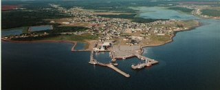
Shippagan is a Canadian town within Shippegan Parish, Gloucester County, New Brunswick.

Cap-Pelé is a former village in Westmorland County, New Brunswick, Canada. It held village status prior to 2023 and is now part of the town of Cap-Acadie.

<span class="mw-page-title-main">Petitcodiac, New Brunswick</span> Place in New Brunswick, Canada

Petitcodiac is a former village in Westmorland County, New Brunswick, Canada. It held village status prior to 2023 and is now part of the village of Three Rivers.

Chipman is a community in Queens County, New Brunswick, Canada. It held village status prior to 2023 and is now part of the village of Grand Lake.

<span class="mw-page-title-main">St. George, New Brunswick</span> Unincorporated settlement in New Brunswick, Canada

St. George is a community in the Rural Community of Eastern Charlotte, in Charlotte County, New Brunswick, Canada; it was a town until the end of 2022 and is now part of the rural community of Eastern Charlotte. It is located where the Magaguadavic River flows into the Bay of Fundy, between Passamaquoddy Bay and Lake Utopia.

Balmoral is a former village in Restigouche County, New Brunswick, Canada. It held village status prior to 2023 and is now part of the village of Bois-Joli. It is approximately 10 kilometres south of Dalhousie. Balmoral also contains the neighbourhoods of Blair Athol, Saint-Maure, Selwood, and Upper Balmoral.

Eel River Crossing is a former village in Restigouche County, New Brunswick, Canada. It held village status prior to 2023 and is now part of the village of Bois-Joli.

Kedgwick is a Canadian incorporated rural community in northern New Brunswick, Canada. On 1 January 2023, Kedgwick annexed a large area including the local service districts of St. Jean Baptiste – Menneval and White's Brook, with parts of two others; revised census figures have not been released.

<span class="mw-page-title-main">Lamèque</span> Place in New Brunswick, Canada

Lamèque is a former town in Gloucester County, New Brunswick, Canada. It held town status prior to 2023 and is now part of the town of Île-de-Lamèque.

Maisonnette is a former village in Gloucester County, New Brunswick, Canada. It held village status prior to 2023 but is now part of the town of Rivière-du-Nord.

<span class="mw-page-title-main">Le Goulet, New Brunswick</span> Place in New Brunswick, Canada

Le Goulet is a former village in Gloucester County, New Brunswick, Canada. Located several kilometres east-southeast of downtown Shippagan, it sits on the Gulf of St. Lawrence. Formerly an incorporated village, it is now part of the town of Shippagan.

Sainte-Marie-Saint-Raphaël is a former village in Gloucester County, New Brunswick, Canada. It held village status prior to 2023 and is now part of the town of Île-de-Lamèque.
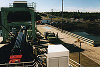
<span class="mw-page-title-main">St. Martins, New Brunswick</span> Place in New Brunswick, Canada

St. Martins is a former village on the Bay of Fundy now part of the village of Fundy-St. Martins, Canada.

<span class="mw-page-title-main">Rivière-Verte, New Brunswick</span> Neighbourhood in Madawaska, New Brunswick, Canada

Rivière-Verte is a neighbourhood in Edmundston. It held village status prior to 2023.

<span class="mw-page-title-main">Grand-Bouctouche</span> Place in New Brunswick, Canada

Grand-Bouctouche is a Canadian town in Kent County, New Brunswick.

References

  1. 1 2 3 4 "Population and dwelling counts: Canada, provinces and territories, census divisions and census subdivisions (municipalities), New Brunswick". Statistics Canada. 9 February 2022. Retrieved 21 February 2022.
  2. Hamilton, William (1978). The Macmillan Book of Canadian Place Names. Toronto: Macmillan. p. 71. ISBN   0-7715-9754-1.
  3. "Local Governments Establishment Regulation – Local Governance Act". Government of New Brunswick. 12 October 2022. Retrieved 20 January 2023.
  4. "RSC 10 Southwest Regional Service Commission". Government of New Brunswick. Retrieved 20 January 2023.
  5. "Proposed entity names reflect strong ties to nature and history" (Press release). Irishtown, New Brunswick: Government of New Brunswick. 25 May 2022. Retrieved 20 January 2023.
  6. 1 2 Statistics Canada: 1996, 2001, 2006, 2011 census
  7. "2021 Community Profiles". 2021 Canadian Census . Statistics Canada. 4 February 2022. Retrieved 19 October 2023.
  8. "2011 Community Profiles". 2011 Canadian Census . Statistics Canada. 21 March 2019. Retrieved 19 May 2014.
  9. "2006 Community Profiles". 2006 Canadian Census . Statistics Canada. 20 August 2019.
  10. "2001 Community Profiles". 2001 Canadian Census . Statistics Canada. 18 July 2021.