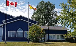
Nackawic-Millville

Last updated

Nackawic-Millville
Rural community
Nackawic Town Hall.jpg
Canada New Brunswick location map 2.svg
Red pog.svg
Nackawic-Millville
Location within New Brunswick
Coordinates: 45°59′47″N67°14′22″W / 45.99639°N 67.23944°W / 45.99639; -67.23944 Coordinates: 45°59′47″N67°14′22″W / 45.99639°N 67.23944°W / 45.99639; -67.23944
CountryCanada
Province New Brunswick
County York County
Regional service commission Capital Region
IncorporatedJanuary 1, 2023
Elevation
139 m (455 ft)
Time zone UTC-4 (AST)
  Summer (DST) UTC-3 (ADT)
Postal code(s)
E6E, E6G
Area code 506
Telephone Exchanges575, 593

Nackawic-Millville is a rural community in the Canadian province of New Brunswick. It was formed through the 2023 New Brunswick local governance reforms.

Contents

History

Nackawic-Millville was incorporated on January 1, 2023 via the amalgamation of the former town of Nackawic and the former village of Millville as well as the concurrent annexation of adjacent unincorporated areas. [1]

Economy

Local business people, community leaders and other economic development groups form the Nackawic Region Economic Development Team designed to encourage and assist business development in the Nackawic and Mactaquac Headpond area. Nackawic also has membership in the South West Development Corporation. [2]

Attractions

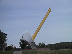
World's Largest Axe Worlds Largest Axe Nackawic NB.JPG
World's Largest Axe

Nackawic-Millville is home to the World's Largest Axe. [3]

Government

Final Council (at dissolution) [4]
Former mayors

Education

The Rural Community has four schools:

Notable people

See also

Related Research Articles

<span class="mw-page-title-main">Campbellton, New Brunswick</span> City in New Brunswick, Canada

Campbellton is a city in Restigouche County, New Brunswick, Canada.

<span class="mw-page-title-main">St. Stephen, New Brunswick</span> Town in New Brunswick, Canada

St. Stephen is a Canadian town in Charlotte County, New Brunswick, situated on the east bank of the St. Croix River around the intersection of New Brunswick Route 170 and the southern terminus of New Brunswick Route 3. The St. Croix River marks a section of the Canada–United States border, forming a natural border between Calais, Maine and St. Stephen. U.S. Route 1 parallels the St. Croix river for a few miles, and is accessed from St. Stephen by three cross-border bridges.

<span class="mw-page-title-main">Nackawic</span> Place in New Brunswick, Canada

Nackawic is a former town in New Brunswick, Canada. It held town status prior to 2023 and is now part of the rural community of Nackawic-Millville. It is approximately 65 km west of the city of Fredericton on the east bank of the Saint John River.

<span class="mw-page-title-main">Rothesay, New Brunswick</span> Town in New Brunswick, Canada

Rothesay is a town located in Kings County, New Brunswick, Canada. It is adjacent to the City of Saint John along the Kennebecasis River.

<span class="mw-page-title-main">Mactaquac Dam</span> Dam in York County, New Brunswick

The Mactaquac Dam is an embankment dam used to generate hydroelectricity in Mactaquac, New Brunswick. It dams the waters of the Saint John River and is operated by NB Power with a capacity to generate 670 megawatts of electricity from 6 turbines; this represents 20 percent of New Brunswick's power demand.

<span class="mw-page-title-main">York North (New Brunswick provincial electoral district)</span> Provincial electoral district in New Brunswick, Canada

York North is a provincial electoral district for the Legislative Assembly of New Brunswick, Canada. It was first created in the 1973 out of the old two member district of York by taking those parts of York County outside the city of Fredericton and north of the Saint John River. The districts boundaries were significantly altered in 1994 — losing the villages of Nackawic, Millville and surrounding communities — and its name was changed to Mactaquac as a result. In 2006, its boundaries were restored to nearly its original configuration and though the Electoral Boundaries Commission did not recommend a name change, the legislature later took the decision to revert it to its original name as well.

<span class="mw-page-title-main">Pokiok, New Brunswick</span>

Pokiok is a rural community in York County, New Brunswick, Canada.

<span class="mw-page-title-main">St. George, New Brunswick</span> Unincorporated settlement in New Brunswick, Canada

St. George is a community in the Rural Community of Eastern Charlotte, in Charlotte County, New Brunswick, Canada; it was a town until the end of 2022. It is located where the Magaguadavic River flows into the Bay of Fundy, between Passamaquoddy Bay and Lake Utopia.

<span class="mw-page-title-main">Bath, New Brunswick</span> Unincorporated community in New Brunswick, Canada

Bath is a community on the Saint John River in Carleton County, New Brunswick, Canada. It held village status prior to 2023.

<span class="mw-page-title-main">Blackville, New Brunswick</span> Place in New Brunswick, Canada

Blackville is a former village in Northumberland County, New Brunswick, Canada. It is now part of the rural commmunity of Miramichi River Valley.

Millville is a former village in York County, New Brunswick, Canada. It held village status prior to 2023 and is now part of the rural community of Nackawic-Millville. It is at the intersection of Route 104 and Route 605.

A local service district (LSD) was a provincial administrative unit for the provision of local services in the Canadian province of New Brunswick. LSDs originally covered areas of the province that maintained some services but were not made municipalities when the province's former county municipalities were dissolved at the start of 1967; eventually all of rural New Brunswick was covered by the LSD system. They were defined in law by the Local Service Districts Regulation of the Municipalities Act. In 2017, the Municipalities Act was replaced by the Local Governance Act, which continued the Local Service Districts Regulation.

Hanwell is an incorporated rural community and former local service district within Kingsclear Parish in York County, New Brunswick, Canada. It is located on Route 640 immediately southwest of Fredericton.

Robert Blaine Simpson is a former politician in New Brunswick, Canada.

<span class="mw-page-title-main">Queensbury Parish, New Brunswick</span> Parish in New Brunswick, Canada

Queensbury is a civil parish in York County, New Brunswick, Canada.

<span class="mw-page-title-main">Southampton Parish, New Brunswick</span> Parish in New Brunswick, Canada

Southampton is a civil parish in York County, New Brunswick, Canada.

<span class="mw-page-title-main">Bright Parish, New Brunswick</span> Parish in New Brunswick, Canada

Bright is a civil parish in York County, New Brunswick, Canada.

<span class="mw-page-title-main">Nackawic Senior High School</span> Public school in Nackawic, New Brunswick, Canada

Nackawic Senior High School is a high school located in Nackawic, New Brunswick, Canada. Nackawic High receives new students primarily from Nackawic Middle School and Keswick Valley Memorial School, if they do not choose to attend Leo Hayes High School in Fredericton. The school houses the Nackawic Public-School Library, accessible by the public.

Route 615 is a 23.2-kilometre (14.4 mi) long east–west secondary highway in the eastern portion of New Brunswick, Canada.

References

  1. "Local Governments Establishment Regulation – Local Governance Act". Government of New Brunswick. August 30, 2022. Retrieved January 15, 2023.
  2. Mactaquac Country and Nackawic nackawic.com
  3. "Town of Nackawic - Home of the World's Largest Axe". Town of Nackawic. Retrieved August 15, 2019.
  4. "Mayor and Council". nackawic.com. Retrieved August 13, 2017.