Hartland, New Brunswick

Last updated

Hartland
Town
HartlandBridge1.jpg
Hartland Bridge, with Hartland in the background
Hartland NB seal.jpg
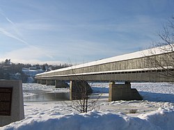
Nickname: 
Home of the World's Longest Covered Bridge
Canada New Brunswick location map 2.svg
Red pog.svg
Hartland
Coordinates: 46°17′51″N67°31′39″W / 46.29742°N 67.52742°W / 46.29742; -67.52742
Country Canada
Provinces of Canada New Brunswick
County Carleton County
Founded1813
Incorporated October 2, 1918
Government
  TypeTown Council
  MayorTracey Demerchant
Area
[1]
  Land9.50 km2 (3.67 sq mi)
Elevation
41 to 103 m (134 to 338 ft)
Population
 (2021) [1]
  Total933
  Density98.2/km2 (254/sq mi)
  Change (2016–21)
Decrease2.svg 2.5%
Time zone UTC-4 (AST)
  Summer (DST) UTC-3 (ADT)
Canadian Postal code
E7P
Area code 506
Telephone Exchange375
NTS Map 21J5 Florenceville
GNBC CodeDAJRT [2]
Website http://www.townofhartland.ca

Hartland is a town in Carleton County, New Brunswick, Canada.

Contents

On 1 January 2023, Hartland annexed all or part of seven local service districts, greatly expanding its area and population. [3] [4] The annexed communities' names remain in official use. [5] Revised census figures have not been released.

Geography

Hartland is situated on the Saint John River in the central-western portion of the province in the agricultural heartland of Carleton County.

History

The first settler in the area of what would become Hartland was William Orser (b.1762) and his son William Jr. [6] William traveled there from New York with his wife and six children. His wife died of an illness and he remarried to a widow, Mary Blake, who also had six children. The pair later conceived an additional six children. The land was settled in 1797, and granted in 1809. [7]

The town was named Hartland in 1874, to honour James R. Hartley, a surveyor and MLA. [8]

It is the hometown of two of New Brunswick's premiers during the 20th century: Hugh John Flemming and Richard Hatfield. U.S. Congressmen Isaac & Samuel Stephenson and Prince Edward Island's Lieutenant-Governor Barbara Oliver Hagerman are also from Hartland. Renowned Canadian poet Alden Nowlan also lived in the town for several formative years while working for the Hartland Observer newspaper.

The town is best known for being the site of the Hartland Bridge, the longest covered bridge in the world. Originally opened on July 4, 1901, the 1,282 foot (390.75 m) bridge is a national historic site. The bridge was covered as part of major repairs in 1921, and the pedestrian walkway added in 1945.

Prior to the building of the Mactaquac Dam, Hartland was also famous for its salmon pools, [9] [10] located slightly upstream of the Hartland Bridge.

Hartland is the headquarters of the North American trucking company Day & Ross, itself a subsidiary of McCain Foods, as well as home to the New Brunswick Bible Institute.

Demographics

In the 2021 Census of Population conducted by Statistics Canada, Hartland had a population of 933 living in 374 of its 390 total private dwellings, a change of

Disasters

Longest covered bridge, showing pedestrian addition, with ice in the river HartlandBridge2.jpg
Longest covered bridge, showing pedestrian addition, with ice in the river

Fires

July 15, 1907

An arsonist started a fire which consumed a large part of the town. [11] [12] The town was rebuilt.

October 24, 1946

The town's dehydration plant, used to dehydrate potatoes, was destroyed by fire. [13] The adjacent glucose and starch plants were also consumed. [14]

August 25, 1980

A fire destroyed many businesses on Main Street. [15]

Floods

Being built close to the Saint John River, the town is usually affected by the annual spring freshet. Ice jams threaten the Hartland Bridge, [16] it being a choke point for loose ice.

Notable people

See also

Related Research Articles

<span class="mw-page-title-main">Carleton County, New Brunswick</span> County in New Brunswick, Canada

Carleton County is located in west-central New Brunswick, Canada.

<span class="mw-page-title-main">St. Stephen, New Brunswick</span> Town in New Brunswick, Canada

St. Stephen is a Canadian town in Charlotte County, New Brunswick, situated on the east bank of the St. Croix River around the intersection of New Brunswick Route 170 and the southern terminus of New Brunswick Route 3. The St. Croix River marks a section of the Canada–United States border, forming a natural border between Calais, Maine and St. Stephen. U.S. Route 1 parallels the St. Croix river for a few miles, and is accessed from St. Stephen by three cross-border bridges.

<span class="mw-page-title-main">Centreville, New Brunswick</span> Place in New Brunswick, Canada

Centreville is a former village in Carleton County, New Brunswick, Canada. It held village status prior to 2023 and is now part of the town of Carleton North.

<span class="mw-page-title-main">Nackawic</span> Place in New Brunswick, Canada

Nackawic is a former town in New Brunswick, Canada. It held town status prior to 2023 and is now part of the rural community of Nackawic-Millville. It is approximately 65 km west of the city of Fredericton on the east bank of the Saint John River.

<span class="mw-page-title-main">Woodstock, New Brunswick</span> Town on the Saint John River, western New Brunswick, Canada

Woodstock is a town in Carleton County, New Brunswick, Canada on the Saint John River, 103 km upriver from Fredericton at the mouth of the Meduxnekeag River. It is near the Canada–United States border and Houlton, Maine and the intersection of Interstate 95 and the Trans-Canada Highway making it a transportation hub. It is also a service centre for the potato industry and for more than 26,000 people in the nearby communities of Hartland, Florenceville-Bristol, Centreville, Bath and Lakeland Ridges for shopping, employment and entertainment.

<span class="mw-page-title-main">Tobique—Mactaquac</span> Federal electoral district in New Brunswick, Canada

Tobique—Mactaquac is a federal electoral district in New Brunswick, Canada, that has been represented in the House of Commons of Canada since 1997.

<span class="mw-page-title-main">Fredericton (federal electoral district)</span> Federal electoral district in New Brunswick, Canada

Fredericton is a federal electoral district in New Brunswick, Canada, that has been represented in the House of Commons of Canada since 1988. Its population in 2021 was 87,436. Its predecessor riding, York—Sunbury, was represented in the House of Commons from 1917 to 1988. Following the 2022 Canadian federal electoral redistribution, the riding will be re-named Fredericton—Oromocto, at the first election held after approximately April 2024. Its border with Tobique—Mactaquac will be rerouted to follow the northern border of the City of Fredericton, and it will lose the remainder of the Parishes of Maugerville, Sheffield and Canning to Miramichi—Grand Lake; and will lose Burton Parish to Saint John—St. Croix, except for those parts of the parish that will be transferred to the Town of Oromocto in 2023.

<span class="mw-page-title-main">Dorchester, New Brunswick</span> Place in New Brunswick, Canada

Dorchester is a former village in Westmorland County, New Brunswick, Canada. It held village status prior to 2023 and is now part of the town of Tantramar. It is named for Guy Carleton, 1st Baron Dorchester, an 18th-century Governor-General of the old Province of Quebec.

<span class="mw-page-title-main">New Brunswick Southwest</span> Federal electoral district in New Brunswick, Canada

New Brunswick Southwest is a federal electoral district in New Brunswick, Canada, that has been represented in the House of Commons of Canada since 2004. Its population in 2016 was 65,287.

<span class="mw-page-title-main">Mactaquac Dam</span> Dam in York County, New Brunswick

The Mactaquac Dam is an embankment dam used to generate hydroelectricity in Mactaquac, New Brunswick. It dams the waters of the Saint John River and is operated by NB Power with a capacity to generate 670 megawatts of electricity from 6 turbines; this represents 20 percent of New Brunswick's power demand.

<span class="mw-page-title-main">St. George, New Brunswick</span> Unincorporated settlement in New Brunswick, Canada

St. George is a community in the Rural Community of Eastern Charlotte, in Charlotte County, New Brunswick, Canada; it was a town until the end of 2022 and is now part of the rural community of Eastern Charlotte. It is located where the Magaguadavic River flows into the Bay of Fundy, between Passamaquoddy Bay and Lake Utopia.

<span class="mw-page-title-main">Borden-Carleton</span> Town in Prince Edward Island, Canada

Borden-Carleton is a town in Prince County in the Canadian province of Prince Edward Island. It is situated on the south shore fronting on the Northumberland Strait. The town was originally incorporated as a community on April 12, 1995, through the amalgamation of the town of Borden and the community of Carleton. The town of Borden opted to demote its status to a community in light of a declining tax base with the pending completion of the Confederation Bridge and the closure of the Marine Atlantic ferry service. Borden-Carleton became a town on July 31, 2012.

<span class="mw-page-title-main">Bath, New Brunswick</span> Place in New Brunswick, Canada

Bath is a former village on the Saint John River in Carleton County, New Brunswick, Canada. It held village status prior to 2023 and is now part of the town of Carleton North.

<span class="mw-page-title-main">Doaktown</span> Village in New Brunswick, Canada

Doaktown is a Canadian village in Northumberland County, New Brunswick.

<span class="mw-page-title-main">Hartland Covered Bridge</span> Covered bridge in New Brunswick, Canada

The Hartland Covered Bridge in Hartland, New Brunswick, is the world's longest covered bridge, at 1,282 feet (391 m) long. It crosses the Saint John River from Hartland to Somerville, New Brunswick, Canada. The framework consists of seven small Howe Truss bridges joined on six piers.

<span class="mw-page-title-main">Somerville, New Brunswick</span>

Somerville is a Canadian rural community in Carleton County, New Brunswick.

<span class="mw-page-title-main">Brighton Parish, New Brunswick</span> Parish in New Brunswick, Canada

Brighton is a civil parish in Carleton County, New Brunswick, Canada, northeast of Woodstock, extending from the eastern bank of the Saint John River to the York County line.

<span class="mw-page-title-main">Bright Parish, New Brunswick</span> Parish in New Brunswick, Canada

Bright is a civil parish in York County, New Brunswick, Canada.

<span class="mw-page-title-main">Nackawic Senior High School</span> Public school in Nackawic-Millville, New Brunswick, Canada

Nackawic Senior High School is a high school located in Nackawic-Millville, New Brunswick, Canada. Nackawic High receives new students primarily from Nackawic Middle School and Keswick Valley Memorial School, if they do not choose to attend Leo Hayes High School in Fredericton. The school houses the Nackawic Public-School Library, accessible by the public.

The Becaguimec Stream is a minor tributary of the Saint John River in the Canadian Province of New Brunswick. It rises in the hilly woods along the county line dividing Carleton County, Canada from York County, Canada in the western region of the province. Its watershed is adjacent to the South Branch of the Southwest Miramichi River, the Nashwaak River, the Keswick River and the Nackawic Stream.

References

  1. 1 2 3 "Census Profile of Hartland". Statistics Canada. 6 December 2022. Retrieved 17 January 2023.
  2. "Hartland". Geographical Names Data Base . Natural Resources Canada.
  3. "Local Governments Establishment Regulation – Local Governance Act". Government of New Brunswick. 12 October 2022. Retrieved 11 January 2023.
  4. "RSC 12 - Western Valley Regional Service Commission". Government of New Brunswick. 31 January 2022. Retrieved 17 January 2023.
  5. "Proposed entity names reflect strong ties to nature and history" (Press release). Irishtown, New Brunswick: Government of New Brunswick. 25 May 2022. Retrieved 20 January 2023.
  6. Ketchum, T. C. L. (April 2008) [1922]. A Short History of Carleton County, New Brunswick. READ BOOKS. p. 61. ISBN   978-1-4086-9650-7 . Retrieved 6 November 2010.
  7. Barter, Samuel G. (1951). "Three". A Short History of the Orser Family. Avondale, New Brunswick.{{cite book}}: CS1 maint: location missing publisher (link)
  8. Hamilton, William B. (1996). Place names of Atlantic Canada (Repr. ed.). Toronto [u.a.]: Univ. of Toronto Press. p. 83. ISBN   0802004717.
  9. Kennedy, Doris E. (2009). "Hartland Salmon Pool". Hidden History of Hartland. Doris E Kennedy. pp. 197–210. ISBN   978-0-9813773-0-8.
  10. "Gerry Perkins". Archived from the original on 15 July 2011. Retrieved 18 January 2011. With the installation of the Mactaquac Dam, it reduced the salmon fishing on the Saint John River in Hartland to nothing more than a wasted effort for the angler.
  11. Kennedy, Doris E. (2009). "The Fire Monday July 15, 1907". Hidden History of Hartland. Doris E Kennedy. pp. 20–30. ISBN   978-0-9813773-0-8.
  12. "Incendiary Fire at Hartland, N.B." The Ottawa Journal. 16 Jul 1907. p. 12. Retrieved 25 December 2016 via Newspapers.com.
  13. "$300,000 Fire Wipes Out Potato Dehydration Plant". The Ottawa Journal. 25 Oct 1946. p. 24. Retrieved 25 December 2016 via Newspapers.com.
  14. Kennedy, Doris E. (2009). "The Dehydration Plant in Hartland". Hidden History of Hartland. Doris E Kennedy. pp. 163, 165. ISBN   978-0-9813773-0-8.
  15. Kennedy, Doris E. (2009). "Fire of August 1980 - Hartland Changes for Ever". Hidden History of Hartland. Doris E Kennedy. pp. 170–173. ISBN   978-0-9813773-0-8.
  16. Kennedy, Doris E. (2009). "Floods and Ice Jams". Hidden History of Hartland. Doris E Kennedy. pp. 174–178. ISBN   978-0-9813773-0-8.

46°18′N67°31′W / 46.300°N 67.517°W / 46.300; -67.517 (Hartland)