Florenceville-Bristol

Last updated

Florenceville-Bristol
FlorencevilleBridge1.jpg
The Florenceville Bridge across the Saint John River is partly covered.
Florenceville-Bristol logo.png
Motto: 
French Fry Capital of the World [1]
Canada New Brunswick location map 2.svg
Red pog.svg
Location of Florenceville in New Brunswick
Coordinates: 46°26′36″N67°36′55″W / 46.443472°N 67.615222°W / 46.443472; -67.615222
CountryCanada
Province New Brunswick
County Carleton County
Town Carleton North
AmalgamatedJuly 1, 2008
Government
  MP Richard Bragdon
  MLA Margaret Johnson
Area
[2]
  Total15.74 km2 (6.08 sq mi)
Elevation
150 m (492 ft)
Population
 (2021) [2]
  Total1,573
  Density100.0/km2 (259/sq mi)
  Change
2016-2021
Decrease2.svg 1.9%
Time zone UTC-4 (AST)
  Summer (DST) UTC-3 (ADT)
Canadian Postal code
E7L
Area code 506
Telephone Exchange(s)221, 245, 246, 276, 278, 391, 392, 595
Website http://www.florencevillebristol.ca/

Florenceville-Bristol is a former town in the northwestern part of Carleton County, New Brunswick, Canada along the Saint John River. It held town status prior to 2023 and is now part of the town of Carleton North.

Contents

History

Florenceville was originally known as Buttermilk Creek. In 1855 it was renamed Florenceville to honour Florence Nightingale, the famous Crimean War nurse. Florenceville was on the west side of the Saint John River and there the first post office and commercial section of the village was situated. In later years East Florenceville, previously known as Buckwheat Flats, became the commercial centre with five grocery stores and several other small businesses. There is a small strip mall along with several convenience stores and restaurants. The former village of Bristol is located on the Saint John River, in Carleton County, New Brunswick, Canada, approximately 5 kilometres north of Florenceville. It was named after the city of Bristol, England. The name replaced Kent Station in the 1880s. [3]

Present-day Bristol was the site of a battle between Micmac and Maliseet peoples. The area was originally named Shiktehawk, from the Maliseet for "where he killed him". The name was changed when the New Brunswick Railway was constructed and railway officials were unable to pronounce the name correctly. Bristol is located where the Big Shiktehawk and Little Shiktehawk Streams empty into the Saint John River. This was an important stopping point for Native peoples as it was the start of the cross province route. They would canoe up the Big Shiktehawk Stream to Divide where they would portage a short distance to the Miramichi River and make their way to the eastern coast of New Brunswick.

On 1 January 2023, Florenceville-Bristol amalgamated with Bath, Centreville and all or part of nine local service districts to form the new town of Carleton North. [4] [5] The community's name remains in official use. [6]

Demographics

In the 2021 Census of Population conducted by Statistics Canada, Florenceville-Bristol had a population of 1,573 living in 681 of its 729 total private dwellings, a change of

Economy

Florenceville-Bristol is home to the corporate headquarters for McCain Foods, the largest producer of French fries in the world. McCain also operates the Florenceville Airport, with a single paved runway located amid agricultural fields on the west side of the river.

Mountain View Packers is another potato-centred business that calls Florencenville-Bristol home. [7] Mountain View Packers is a business that specializes in the processing of potatoes and cauliflower for the fresh market. Mountain View Packers sources all of their potatoes from local farmers while the cauliflower is grown on site at their own farm. [8]

Florenceville-Bristol is also home to H.J. Crabbe & Sons Lumber Mill. This long-running family business specializes in its quality softwood lumber made mainly from Balsam Fir and White Spruce. The company has also recently built a new mill in the town to produce wood stove pellets in order to use more of what would be scrap material to help cut down on waste. The company is also one of the largest landowners in the province, next to Irving and Frasier.

A.N.D. Communications & Graphics is a graphics company situated in Florenceville-Bristol. A.N.D. Communications & Graphics specializes in providing the local area with signage and local advertisement solutions. [9]

Education

Both villages had schools offering grades 1 through 12 until 1956 when the Florenceville Regional High School was opened accommodating grades 7 through 12. The original schools became the elementary schools. Eventually these were replaced by an elementary school on the east side of the river. The Regional High School became a middle school when Carleton North High School was built in Bristol, NB. It was later decided that starting in the year 1996 the middle school students would not begin high school until grade 9.

Bristol is the home of Carleton North High School as well as Bristol Elementary School.

Physical geography

Florenceville-Bristol lies within the Appalachian Mountain Range. The town sits in the Saint John River Valley. On each side of the town lie rolling mountains peaking at 300–400 metres. The borough of Florenceville lies on a flat that has extremely rich soil due to past volcanic activity before the last ice age. The borough of Bristol also lies on a flat, but much lower to the river and lower parts of the borough floods during the spring.

Geology

The bedrock underlying Florenceville-Bristol at its oldest is part of the White Head Formation consisting of limestone and calcareous shales of Late Ordovician to Early Silurian in age. Later in history more sedimentary rocks were deposited forming the Smyrna Mills Formation during the Silurian, consisting of shales, limestones, and conglomerates. The range of mountains from North to South along the Eastern side of the Saint John River known as Carr Mountain, The Pinnacle, and Oakland Mountain (N to S) are also part of the Smyrna Mills Formation and consist of mafic volcanic flows (basalt) and tuff. Within these mountains there are also two gabbro tubes that are Early Devonian in age. These tubes probably were the magma feeding tubes for volcanic flow that would have once overlain the existing rock, but have since been eroded. Florenceville-Bristol are also extensively terraced with sands and gravels from both the workings of the Saint John River and its tributaries and also from the existence of a huge post-glacial lake that existed in the area for some time after the last Ice Age. In the areas that the bedrock is not covered by this aggregate material, the bedrock is covered by a thin veneer of glacial till. There is also an extensive fault trending through Florenceville-Bristol from NE to SW which the Saint John River follows for a short distance through the town, causing its seemingly odd bend in flow in the local area.

Climate

The town gets a fair amount of precipitation, although major paralyzing snow and rain storms such as blizzards and hurricanes are uncommon but do happen on occasion. On average, Florenceville receives approximately 1100 mm of precipitation per year. Snowfall is common between late November and early April, and snow usually stays on the ground beginning in December. Flooding occurs during the spring of most years and affects the low-lying areas of Florenceville-Bristol.

Climate data for Centreville
MonthJanFebMarAprMayJunJulAugSepOctNovDecYear
Record high °C (°F)12.0
(53.6)
11.0
(51.8)
19.5
(67.1)
30.0
(86.0)
35.0
(95.0)
35.0
(95.0)
35.0
(95.0)
35.0
(95.0)
31.0
(87.8)
26.1
(79.0)
19.0
(66.2)
13.3
(55.9)
35.0
(95.0)
Mean daily maximum °C (°F)−6.2
(20.8)
−4.4
(24.1)
1.4
(34.5)
8.5
(47.3)
17.2
(63.0)
21.9
(71.4)
24.6
(76.3)
23.6
(74.5)
17.9
(64.2)
10.8
(51.4)
3.6
(38.5)
−4.0
(24.8)
9.6
(49.3)
Mean daily minimum °C (°F)−16.9
(1.6)
−15.4
(4.3)
−9.0
(15.8)
−1.6
(29.1)
4.3
(39.7)
9.3
(48.7)
12.1
(53.8)
11.2
(52.2)
6.2
(43.2)
1.4
(34.5)
−4.1
(24.6)
−13.7
(7.3)
−1.4
(29.5)
Record low °C (°F)−37.2
(−35.0)
−37.8
(−36.0)
−31.1
(−24.0)
−17.8
(0.0)
−10.0
(14.0)
−2.2
(28.0)
0.0
(32.0)
−3.5
(25.7)
−7.0
(19.4)
−10.0
(14.0)
−21.0
(−5.8)
−37.0
(−34.6)
−37.8
(−36.0)
Average precipitation mm (inches)80.8
(3.18)
54.9
(2.16)
88.5
(3.48)
78.9
(3.11)
97.5
(3.84)
101.4
(3.99)
95.7
(3.77)
100.0
(3.94)
99.1
(3.90)
87.6
(3.45)
93.1
(3.67)
91.8
(3.61)
1,069.3
(42.10)
Source: 1971-2000 Environment Canada [10]

Attractions

It also has a free public art gallery. The Andrew and Laura McCain Gallery is a non-profit, community-supported gallery that shows about nine exhibitions a year of everything from exhibitions on loan from the National Gallery of Canada to the work of local school children.

Florenceville-Bristol is also home to the New Brunswick Potato Museum (Potato World) and Shogomoc Historical Railway Site. The Shogomoc Historical Railway Site showcases a restored CPR train station and three CPR cars and is home to FRESH "fine dining". Hunter Brothers Farm Market and Corn Maze.

The town celebrates many festivals throughout the year; Festival of Flavour, which takes place August and showcases a variety of wine related events, Canada Day-July, Snow Blast- February, Haunted Train October, Buttermilk Creek Fall Festival-September and more.

Throughout the summer season, July to September, the town is host to an outdoor summer market, every Thursday from 10-2 pm at the Riverside Park. The outdoor summer market features food, produce, craft, woodworking, flower, baked goods, local meat and jewellery vendors. Each week showcases a different musical performance from local entertainers.

The town is the site of the Florenceville Bridge, a covered bridge built in 1907 that is unique in New Brunswick in combining a wooden covered bridge with steel trusses for the central spans over the Saint John River.

Located just outside the town limits is a replica Noah's Ark, a 2/3-scale model of the Biblical Ark that Noah built, as described in the Christian Old Testament. The replica ark contains the offices and student dorms for a private Bible school, The School of The Spirit, run by the Burnham Road Ministries. The sight of a 300-foot boat in the middle of potato fields within sight of Bristol and Oakland Mountain often attracts curious visitors.

New street lights joining Florenceville and Bristol were turned on November 18, 2014.

Notable people

See also

Related Research Articles

<span class="mw-page-title-main">Hartland, New Brunswick</span> Town in New Brunswick, Canada

Hartland is a town in Carleton County, New Brunswick, Canada.

<span class="mw-page-title-main">Centreville, New Brunswick</span> Place in New Brunswick, Canada

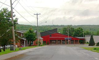
Centreville is a former village in Carleton County, New Brunswick, Canada. It held village status prior to 2023 and is now part of the town of Carleton North.

<span class="mw-page-title-main">Woodstock, New Brunswick</span> Town on the Saint John River, western New Brunswick, Canada

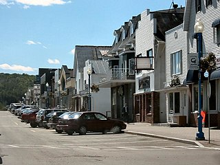
Woodstock is a town in Carleton County, New Brunswick, Canada on the Saint John River, 103 km upriver from Fredericton at the mouth of the Meduxnekeag River. It is near the Canada–United States border and Houlton, Maine and the intersection of Interstate 95 and the Trans-Canada Highway making it a transportation hub. It is also a service centre for the potato industry and for more than 26,000 people in the nearby communities of Hartland, Florenceville-Bristol, Centreville, Bath and Lakeland Ridges for shopping, employment and entertainment.

The Wolastoqiyik, also Wəlastəkwewiyik, Malecite or Maliseet are an Algonquian-speaking First Nation of the Wabanaki Confederacy. They are the Indigenous people of the Wolastoq valley and its tributaries. Their territory extends across the current borders of New Brunswick and Quebec in Canada, and parts of Maine in the United States.

<span class="mw-page-title-main">Grand Falls, New Brunswick</span> Town in New Brunswick, Canada

Grand Falls is a town in northwestern New Brunswick, Canada, on the Saint John River. Its name comes from a waterfall created by a series of rock ledges over which the river drops 23 metres (75 ft).

The history of Fredericton stretches from prehistory to the modern day. Fredericton, New Brunswick was first inhabited by the Mi'kmaq and Maliseet peoples. European settlement of the area began with the construction of Fort Nashwaak by the French in 1692. In 1783, the United Empire Loyalists settled Ste. Anne's Point, and in the next year, renamed the settlement Frederick's Town. The name was later shorted to Fredericton in April 1785.

<span class="mw-page-title-main">Bath, New Brunswick</span> Place in New Brunswick, Canada

Bath is a former village on the Saint John River in Carleton County, New Brunswick, Canada. It held village status prior to 2023 and is now part of the town of Carleton North.

Route 110 is 15.9-kilometre (9.9 mi) long highway in New Brunswick, Canada; running from the Canada–US border crossing at Bridgewater, Maine as a continuation of Boundary Line Road, a connector to U.S. Route 1 (US 1). The route crosses through Carleton County, crossing Route 2 in Centreville. The route runs along the Saint John River before reaching Florenceville-Bristol, where it terminates at an intersection with Route 130 on the riverbank.

<span class="mw-page-title-main">History of New Brunswick</span>

The history of New Brunswick covers the period from the arrival of the Paleo-Indians thousands of years ago to the present day. Prior to European colonization, the lands encompassing present-day New Brunswick were inhabited for millennia by the several First Nations groups, most notably the Maliseet, Mi'kmaq, and the Passamaquoddy.

The Tobique River is a river in northwestern New Brunswick, Canada. The river rises from Nictau Lake in Mount Carleton Provincial Park and flows for 148 kilometres to its confluence with the Saint John River near Perth-Andover.

<span class="mw-page-title-main">Wicklow Parish, New Brunswick</span> Parish in New Brunswick, Canada

Wicklow is a geographic parish in Carleton County, New Brunswick, Canada, forming the northwestern corner of Carleton County.

<span class="mw-page-title-main">Perth Parish, New Brunswick</span> Parish in New Brunswick, Canada

Perth is a geographic parish in Victoria County, New Brunswick, Canada.

<span class="mw-page-title-main">Kent Parish, New Brunswick</span> Parish in New Brunswick, Canada

Kent is a geographic parish in the northeastern corner of Carleton County, New Brunswick, Canada.

<span class="mw-page-title-main">Peel Parish, New Brunswick</span> Parish in New Brunswick, Canada

Peel is a geographic parish in Carleton County, New Brunswick, Canada, situated on the eastern bank of the Saint John River.

<span class="mw-page-title-main">Simonds Parish, Carleton County, New Brunswick</span> Parish in New Brunswick, Canada

Simonds is a geographic parish in Carleton County, New Brunswick, Canada, located north of Woodstock on the western bank of the Saint John River.

Carleton North High School is a high school located in Florenceville-Bristol, New Brunswick. Carleton North High School is in the Anglophone West School District and one of the last schools in New Brunswick that participated in the New Brunswick Potato Picking Week.

<span class="mw-page-title-main">Oromocto</span> Town in New Brunswick, Canada

Oromocto is a Canadian town in Sunbury County, New Brunswick.

Knowlesville is a small community in Carleton County in the Canadian province of New Brunswick. Knowlesville is in Aberdeen Parish, with a population in the 2011 Census of 981. It is located approximately 20 km east of Florenceville-Bristol, New Brunswick, along the Knowlesville Road.

The Becaguimec Stream is a minor tributary of the Saint John River in the Canadian Province of New Brunswick. It rises in the hilly woods along the county line dividing Carleton County, Canada from York County, Canada in the western region of the province. Its watershed is adjacent to the South Branch of the Southwest Miramichi River, the Nashwaak River, the Keswick River and the Nackawic Stream.

<span class="mw-page-title-main">Carleton North, New Brunswick</span> Town in New Brunswick, Canada

Carleton North is a town in the Canadian province of New Brunswick. It was formed through the 2023 New Brunswick local governance reforms.

References

  1. "Town of Florenceville-Bristol, NB" . Retrieved August 16, 2019.
  2. 1 2 3 "Census Profile of Florenceville-Bristol". Statistics Canada. December 6, 2022. Retrieved January 15, 2023.
  3. Hamilton, William (1978). The Macmillan Book of Canadian Place Names. Toronto: Macmillan. p. 71. ISBN   0-7715-9754-1.
  4. "Local Governments Establishment Regulation – Local Governance Act". Government of New Brunswick. October 12, 2022. Retrieved January 20, 2023.
  5. "RSC 12 - Western Valley Regional Service Commission". Government of New Brunswick. Retrieved January 20, 2023.
  6. "Proposed entity names reflect strong ties to nature and history" (Press release). Irishtown, New Brunswick: Government of New Brunswick. May 25, 2022. Retrieved January 20, 2023.
  7. "Hall of Recognition". Potato World. Archived from the original on May 6, 2017. Retrieved August 16, 2019.
  8. "Mountain View Packers Ltd. - Home". mountainviewpackers.com. Retrieved December 1, 2016.
  9. "A.N.D. Communication & Graphics". www.andcommunication.ca. Retrieved December 1, 2016.
  10. Environment Canada Canadian Climate Normals 1971–2000. Retrieved 4 July 2011.

46°26′36.5″N67°36′54.8″W / 46.443472°N 67.615222°W / 46.443472; -67.615222