
Kings County is located in southern New Brunswick, Canada. Its historical shire town is Hampton and it was named as an expression of loyalty to the British Crown. Both the Saint John and Kennebecasis rivers pass through the county.

The Kennebecasis River is a tributary of the Saint John River in southern New Brunswick, Canada. The name Kennebecasis is thought to be derived from the Mi'kmaq "Kenepekachiachk", meaning "little long bay place." It runs for approximately 95 kilometres, draining an area in the Caledonia Highlands, an extension of the Appalachian Mountains, inland from the Bay of Fundy.
Apohaqui is an unincorporated community in Kings County, New Brunswick, Canada. It is located on the Kennebecasis River at the confluence of the Millstream River extending approximately from Foxhill to a kilometer east of Riverbank Cemetery on both sides of the Kennebecasis, so that it resides in both Sussex and Studholm parishes on the south and north, respectively.

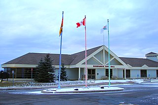
Hampton is a town in Kings County, New Brunswick, Canada.
The Kingston Peninsula is a peninsula in southern New Brunswick, Canada, located between the Saint John River and the Kennebecasis River in Kings County.
Chapel Grove is a Canadian rural community in Kings County, New Brunswick.
Renforth is a Canadian suburban community and former village in Kings County, New Brunswick. It is situated on the south bank of the Kennebecasis River northeast of Saint John.
Nauwigewauk is a rural community in Kings County, New Brunswick, Canada. It is located near the communities of Quispamsis and Lakeside at the mouth of the Hammond River, and borders the town of Hampton. The people of Nauwigewauk are sometimes locally known as Nauwigewaukies.
Quispamsis is a suburban town located in Kings County, New Brunswick, Canada. Located within Saint John's metropolitan area, it borders the town of Rothesay to form the Kennebecasis Valley and is located along the lower Kennebecasis River. As of 2021, the population of Quispamsis was 18,768.
Hammondvale is a Canadian rural community in Kings County, New Brunswick.
Titusville is a rural Canadian community in Kings County, New Brunswick. It was settled in 1819 by John, James, Charles and Jonathan Titus.
The Barnaby River is a tributary of the Miramichi River in New Brunswick, Canada.

Hammond is a geographic parish in Kings County, New Brunswick, Canada.

Cardwell is a geographic parish in Kings County, New Brunswick, Canada, located on the eastern border of the county.

Studholm is a geographic parish in Kings County, New Brunswick, Canada.

Sussex is a geographic parish in Kings County, New Brunswick, Canada.
Norton is a geographic parish in Kings County, New Brunswick, Canada.

Hampton is a geographic parish in Kings County, New Brunswick, Canada.

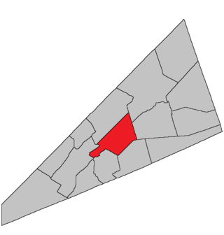
Rothesay is a geographic parish in Kings County, New Brunswick, Canada.

Kingston is a geographic parish in Kings County, New Brunswick, Canada.
