Northwest Miramichi River

Last updated
Northwest Miramichi River, New Brunswick, Canada (IR Walker 1986) 1986 NW Miramichi2.jpg
Northwest Miramichi River, New Brunswick, Canada (IR Walker 1986)
Northwest Miramichi River, New Brunswick, Canada (IR Walker 1986) 1986 NW Miramichi.jpg
Northwest Miramichi River, New Brunswick, Canada (IR Walker 1986)

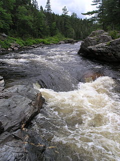
The Northwest Miramichi River or Elmunokun is a river in New Brunswick, Canada. The Mi'kmaq referred to the river as Elmunokun, possibly meaning "a beaver hole" in reference to a deep pool in the river, just below the mouth of the Big Sevogle River, its second largest tributary, after the Little Southwest Miramichi. [1] [2]

New Brunswick province in Canada

New Brunswick is one of four Atlantic provinces on the east coast of Canada. According to the Constitution of Canada, New Brunswick is the only bilingual province. About two-thirds of the population declare themselves anglophones, and one third francophones. One-third of the population describes themselves as bilingual. Atypically for Canada, only about half of the population lives in urban areas, mostly in Greater Moncton, Greater Saint John and the capital Fredericton.

Contents

The Northwest Miramichi River has its origins near Big Bald Mountain in the Miramichi Highlands, part of the Appalachian Mountains in Northumberland County. Initially flowing east, the river turns south at the confluence of the Tomogonops River and Portage River. It continues south to Sunny Corner where it becomes tidal, and then flows east. The Northwest Miramichi River joins the Southwest Miramichi River at Newcastle, NB to form the Miramichi River.

Big Bald Mountain (New Brunswick) mountain in Canada

Big Bald Mountain is a prominent peak in the Canadian province of New Brunswick. It lies adjacent to Colonels Mountain, east of the Christmas Mountains, and near the headwaters of the Northwest Miramichi River, the Sevogle River, and the South Branch Nepisiguit River. It is a well-known feature, in part because of its height, but especially because of its bald summit.

Appalachian Mountains mountain range in the eastern United States and Canada, and France

The Appalachian Mountains, often called the Appalachians, are a system of mountains in eastern North America. The Appalachians first formed roughly 480 million years ago during the Ordovician Period. They once reached elevations similar to those of the Alps and the Rocky Mountains before experiencing natural erosion. The Appalachian chain is a barrier to east–west travel, as it forms a series of alternating ridgelines and valleys oriented in opposition to most highways and railroads running east–west.

Northumberland County, New Brunswick County in New Brunswick, Canada

Northumberland County is located in northeastern New Brunswick, Canada.

The river is noted for Atlantic Salmon fishing. The headwaters offer important spawning sites for Atlantic Salmon; thus, much of the upper river is either closed to fishing, or designated as Crown Reserve and subject to special fishing regulations.

In spring canoeists often run the lower stretch of the river from Miner's Bridge (where the river first crosses Route 430), south to Redbank and Sunny Corner.

Route 430 is a 40-kilometre (25 mi) long mostly North–South secondary highway in the northwest portion of New Brunswick, Canada.

Red Bank, New Brunswick human settlement in New Brunswick, Canada

Red Bank, New Brunswick is a small rural community in Northumberland County, New Brunswick, Canada. It is located approximately 20 km west of Miramichi, New Brunswick, at the mouth of the Little Southwest Miramichi River, at its confluence with the Northwest Miramichi River. The community lies on the southwest bank of the NW Miramichi and opposite its sister community Sunny Corner around the intersection of Route 420 and Route 425.

Sunny Corner, New Brunswick human settlement in New Brunswick, Canada

Sunny Corner, New Brunswick is a rural settlement in Northumberland County, New Brunswick, Canada. It is located approximately 35km west of Miramichi, New Brunswick, on the northeast bank of the Northwest Miramichi River, opposite its sister community, Red Bank. The community has an Irving gas station, a Royal Canadian Legion, a Lions Club which includes a bowling alley, a government garage, a police station serviced by the RCMP, a volunteer fire department, a hockey rink, and a seniors home.

Tributaries

Little Southwest Miramichi River river in New Brunswick, Canada

The Little Southwest Miramichi River is a Canadian river in Northumberland County, New Brunswick. In Mi'kmaq it is referred to as "Tooadook".

See also

Related Research Articles

Miramichi River river in Canada

The Miramichi River is a river located in the east-central part of New Brunswick, Canada. The river drains into Miramichi Bay in the Gulf of St. Lawrence. The name may have been derived from the Montagnais words "Maissimeu Assi", and it is today the namesake of the Miramichi Herald at the Canadian Heraldic Authority.

The name "Miramichi" was first applied to a region in the northeast of New Brunswick, Canada, and has since been applied to other places in Canada and the United States. Although other interpretations have been suggested, it is believed that "Miramichi" was derived from the Montagnais words "Maissimeu Assi", and was perhaps introduced for use in European languages by Jacques Cartier in 1535.

Southwest Miramichi River river in Canada

The Southwest Miramichi River is a river in New Brunswick, Canada.

Renous River river in Canada

The Renous River is a tributary of the Southwest Miramichi River in New Brunswick, Canada.

Dungarvon River river in Canada

The Dungarvon River is a tributary of the Renous River in New Brunswick, Canada.

Miramichi Valley valley in New Brunswick, Canada

The Miramichi Valley is a Canadian river valley and region in the east-central part of New Brunswick. It extends along both major branches of the Miramichi River and their tributaries, however it is generally agreed that the much larger Southwest Miramichi River forms the majority of this region as it is more settled than the Northwest Miramichi River.

The Bartholomew River is a tributary of the Main Southwest Miramichi River in New Brunswick, Canada.

The Cains River is a Canadian river in New Brunswick. It is 113 kilometres long.

Geography of New Brunswick

New Brunswick is one of Canada's three Maritime provinces. While New Brunswick is one of Canada's Maritime Provinces, it differs from its neighbours both ethnoculturally and physiographically. Both Nova Scotia and Prince Edward Island are either wholly or nearly surrounded by water and the ocean therefore tends to define their climate, economy and culture. New Brunswick, on the other hand, although having a significant seacoast, is sheltered from the Atlantic Ocean proper and has a large interior which is removed from oceanic effects. New Brunswick therefore tends to be defined by its rivers rather than its seacoast.

Sevogle River river in Canada

The Sevogle River is a Canadian river in central New Brunswick. It consists of two branches, the North Sevogle and South Sevogle Rivers. Below the confluence of these rivers at the Square Forks, the river is properly referred to as the "Big Sevogle River". This name serves to distinguish it from the "Little Sevogle River", a much smaller tributary to the Northwest Miramichi River.

Nepisiguit River river in Canada

The Nepisiguit River is a major river in northern New Brunswick, Canada, which enters the sea at the city of Bathurst, on the Bay of Chaleur.

North Pole Stream

North Pole Stream is a tributary to the Little Southwest Miramichi River, with its headwaters in the Christmas Mountains of north-central, New Brunswick, Canada. It is an important spawning stream for Atlantic Salmon, and renowned among fly fishers.

Route 420 is a 35-kilometre (22 mi) long mostly East–west secondary highway in the northwest portion of New Brunswick, Canada.

Route 425 is a 30-kilometre (19 mi) long mostly west–east secondary highway in the northwest portion of New Brunswick, Canada.

References

  1. Rayburn, A. (1975) Geographical Names of New Brunswick. Toponymy Study 2. Surveys and Mapping Branch, Energy Mines and Resources Canada, Ottawa
  2. Geographical Names of Canada "Archived copy". Archived from the original on 2009-02-07. Retrieved 2009-02-07.CS1 maint: archived copy as title (link)

Coordinates: 46°57′57.9″N65°35′38.5″W / 46.966083°N 65.594028°W / 46.966083; -65.594028

Geographic coordinate system Coordinate system

A geographic coordinate system is a coordinate system that enables every location on Earth to be specified by a set of numbers, letters or symbols. The coordinates are often chosen such that one of the numbers represents a vertical position and two or three of the numbers represent a horizontal position; alternatively, a geographic position may be expressed in a combined three-dimensional Cartesian vector. A common choice of coordinates is latitude, longitude and elevation. To specify a location on a plane requires a map projection.