
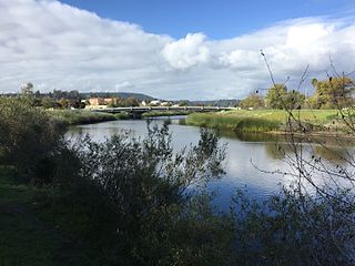
Fredericton is the capital city of the Canadian province of New Brunswick. The city is situated in the west-central portion of the province along the Saint John River, also known by its Indigenous name of Wolastoq, which flows west to east as it bisects the city. The river is the dominant natural feature of the area. One of the main urban centres in New Brunswick, the city had a population of 63,116 and a metropolitan population of 108,610 in the 2021 Canadian census. It is the third-largest city in the province after Moncton and Saint John.

The Snake River is a major river in the interior Pacific Northwest region of the United States. About 1,080 miles (1,740 km) long, it is the largest tributary of the Columbia River, which is the largest North American river that empties into the Pacific Ocean. Beginning in Yellowstone National Park, western Wyoming, it flows across the arid Snake River Plain of southern Idaho, the rugged Hells Canyon on the borders of Idaho, Oregon and Washington, and finally the rolling Palouse Hills of southeast Washington. It joins the Columbia River just downstream from the Tri-Cities, Washington, in the southern Columbia Basin.

The Rogue River in southwestern Oregon in the United States flows about 215 miles (346 km) in a generally westward direction from the Cascade Range to the Pacific Ocean. Known for its salmon runs, whitewater rafting, and rugged scenery, it was one of the original eight rivers named in the Wild and Scenic Rivers Act of 1968. Beginning near Crater Lake, which occupies the caldera left by the explosive volcanic eruption and collapse of Mount Mazama, the river flows through the geologically young High Cascades and the older Western Cascades, another volcanic province. Further west, the river passes through multiple exotic terranes of the more ancient Klamath Mountains. In the Kalmiopsis Wilderness section of the Rogue basin are some of the world's best examples of rocks that form the Earth's mantle. Near the mouth of the river, the only dinosaur fragments ever discovered in Oregon were found in the Otter Point Formation, along the coast of Curry County.

The St. Croix River is a river in northeastern North America, 71 miles (114 km) in length, that forms part of the Canada–United States border between Maine (U.S.) and New Brunswick (Canada). The river rises in the Chiputneticook Lakes and flows south and southeast, between Calais and St. Stephen. It discharges into Passamaquoddy Bay, in the Bay of Fundy.

The Saint John River is a 673-kilometre-long (418 mi) river flowing within the Dawnland region from headwaters in the Notre Dame Mountains near the Maine-Quebec border through western New Brunswick to the northwest shore of the Bay of Fundy. Eastern Canada's longest river, its drainage basin is one of the largest on the east coast at about 55,000 square kilometres (21,000 sq mi). This “River of the Good Wave” and its tributary drainage basin formed the territorial countries of the Wolastoqiyik and Passamaquoddy First Nations prior to European colonization, and it remains a cultural centre of the Wabanaki Confederacy to this day.
The San Lorenzo River is a 29.3-mile-long (47.2 km) river in the U.S. state of California. The name San Lorenzo derives from the Spanish language for "Saint Lawrence" due to its reported sighting on that saint's feast day by Spanish explorers. Its headwaters originate in Castle Rock State Park in the Santa Cruz Mountains and flow south by southeast through the San Lorenzo Valley before passing through Santa Cruz and emptying into Monterey Bay and the Pacific Ocean.

The Elwha River is a 45-mile (72 km) river on the Olympic Peninsula in the U.S. state of Washington. From its source at Elwha snowfinger in the Olympic Mountains, it flows generally north to the Strait of Juan de Fuca. Most of the river's course is within the Olympic National Park.

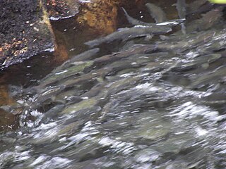
The Chinook salmon is the largest and most valuable species of Pacific salmon. Its common name is derived from the Chinookan peoples. Other vernacular names for the species include king salmon, Quinnat salmon, Tsumen, spring salmon, chrome hog, Blackmouth, and Tyee salmon. The scientific species name is based on the Russian common name chavycha (чавыча).

The Coquitlam River is a tributary of the Fraser River in the Canadian province of British Columbia. The river's name comes from the word Kʷikʷəƛ̓əm which translates to "Red fish up the river". The name is a reference to a sockeye salmon species that once occupied the river's waters.
The history of Fredericton stretches from prehistory to the modern day. Fredericton, New Brunswick was first inhabited by the Mi'kmaq and Maliseet peoples. European settlement of the area began with the construction of Fort Nashwaak by the French in 1692. In 1783, the United Empire Loyalists settled Ste. Anne's Point, and in the next year, renamed the settlement Frederick's Town. The name was later shorted to Fredericton in April 1785.

Alexander "Boss" Gibson was a Canadian industrialist in New Brunswick, Canada. His business interests included sawmills, railways, and a cotton mill. He founded the company town of Marysville, New Brunswick.

The Fredericton Railway Bridge is a former railway bridge in Fredericton, New Brunswick, Canada now used to carry pedestrians and cyclists.

The Elwha Ecosystem Restoration Project is a 21st-century project of the U.S. National Park Service to remove two dams on the Elwha River on the Olympic Peninsula in Washington state, and restore the river to a natural state. It is the largest dam removal project in history and the second largest ecosystem restoration project in the history of the National Park Service, after the Restoration of the Everglades. The controversial project, costing about $351.4 million, has been contested and periodically blocked for decades. It has been supported by a major collaboration among the Lower Elwha Klallam Tribe, and federal and state agencies.
The survival of wild salmon relies heavily on them having suitable habitat for spawning and rearing of their young. This habitat is the main concern for conservationists. Salmon habitat can be degraded by many different factors including land development, timber harvest, or resource extraction. These threats bring about the traditional methods of protecting the salmon, but a new movement aims to protect the habitats before they require intervention.
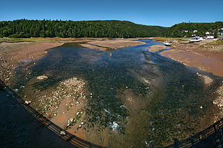
The Upper Salmon River divides Fundy National Park and the village of Alma, New Brunswick at its delta. Here, it is inundated with tidal water from the Salisbury Bay a kilometer to the site of a former dam, making for a large estuary and inter-tidal zone. Its watershed catchment drains a large area in and outside the park, made up of tributaries and their sub-units including Kinnie Brook, Laverty, Forty-five River, Lake Brook, Greenough Brook, and others.

Saint Marys is a geographic parish in York County, New Brunswick, Canada.

Salmon population levels are of concern in the Atlantic and in some parts of the Pacific. Salmon are typically anadromous - they rear and grow in freshwater, migrate to the ocean to reach sexual maturity, and then return to freshwater to spawn. Determining how environmental stressors and climate change will affect these fisheries is challenging due to their lives split between fresh and saltwater. Environmental variables like warming temperatures and habitat loss are detrimental to salmon abundance and survival. Other human influenced effects on salmon like overfishing and gillnets, sea lice from farm raised salmon, and competition from hatchery released salmon have negative effects as well.

Saint Martins is a geographic parish in Saint John County, New Brunswick, Canada.
The Becaguimec Stream is a minor tributary of the Saint John River in the Canadian Province of New Brunswick. It rises in the hilly woods along the county line dividing Carleton County, Canada from York County, Canada in the western region of the province. Its watershed is adjacent to the South Branch of the Southwest Miramichi River, the Nashwaak River, the Keswick River and the Nackawic Stream.
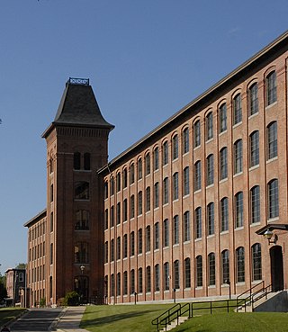
The Marysville Cotton Mill, now known as Marysville Place, is an industrial building in Marysville, New Brunswick, that is a National Historic Site of Canada. It was built by Alexander Gibson in the mid 1880s as he expanded his industrial operations into textile manufacturing at the company town he had established.


