Buctouche River

Last updated

The Buctouche River (colloquially spelt Bouctouche) is a river in eastern New Brunswick, Canada which empties into the Buctouche Bay in the Northumberland Strait in the town of Bouctouche.

New Brunswick province in Canada

New Brunswick is one of four Atlantic provinces on the east coast of Canada. According to the Constitution of Canada, New Brunswick is the only bilingual province. About two thirds of the population declare themselves anglophones and a third francophones. One third of the population describes themselves as bilingual. Atypically for Canada, only about half of the population lives in urban areas, mostly in Greater Moncton, Greater Saint John and the capital Fredericton.

Canada Country in North America

Canada is a country in the northern part of North America. Its ten provinces and three territories extend from the Atlantic to the Pacific and northward into the Arctic Ocean, covering 9.98 million square kilometres, making it the world's second-largest country by total area. Canada's southern border with the United States, stretching some 8,891 kilometres (5,525 mi), is the world's longest bi-national land border. Its capital is Ottawa, and its three largest metropolitan areas are Toronto, Montreal, and Vancouver. As a whole, Canada is sparsely populated, the majority of its land area being dominated by forest and tundra. Consequently, its population is highly urbanized, with over 80 percent of its inhabitants concentrated in large and medium-sized cities, with 70% of citizens residing within 100 kilometres (62 mi) of the southern border. Canada's climate varies widely across its vast area, ranging from arctic weather in the north, to hot summers in the southern regions, with four distinct seasons.

Northumberland Strait strait

The Northumberland Strait is a strait in the southern part of the Gulf of Saint Lawrence in eastern Canada. The strait is formed by Prince Edward Island and the gulf's eastern, southern and western shores.

Contents

The river's name means "Big Little Harbour" in the Mi'kmaq.

River communities

Sainte-Marie-de-Kent is a Canadian village located at the intersection of Route 515 and Route 525 in Kent County, New Brunswick. It is in the parish of Saint Mary.

Hebert is a Canadian community, located in Kent County, New Brunswick. The community is situated in southeastern New Brunswick, to the northwest of Moncton. Hebert is located mainly at the intersection of New Brunswick Route 126 and New Brunswick Route 515. The end of the Bouctouche River ends north of this community.

River crossings

Route 126 is a North/South provincial highway in the Canadian province of New Brunswick. The road runs from Route 117 intersection in Miramichi. The road has a length of approximately 121 kilometers, and services small, otherwise isolated rural communities. In these areas, the highway is often unofficially referred to as "Main Street." The road parallels the New Brunswick East Coast Railway directly to the east. When the highway enters Moncton it changes to Ensley Drive, then Mountain Road.

Route 515 is a 38-kilometre (24 mi) long east-west secondary highway in the south east portion of New Brunswick, Canada.

Route 490 is a North/South provincial highway in the Canadian province of New Brunswick. The road runs from Route 116 intersection in Bass River. The road has a length of approximately 57.6 kilometers, and services small, otherwise isolated rural communities. In these areas, the highway is often unofficially referred to as "Main Street". When the highway enters Moncton it is known as McLaughlin Drive.

See also

Related Research Articles

Kent County, New Brunswick County in New Brunswick, Canada

Kent County is located in east-central New Brunswick, Canada. The county features a unique blend of cultures including Mi'kmaq, Acadian and English Speaking Settlers. Some larger tourist attractions include la dune de Bouctouche, Kouchibouguac National Park, and Bonar Law Commons.

Saint-Antoine, New Brunswick Village in New Brunswick, Canada

Saint-Antoine is a village in Kent County, New Brunswick, Canada. It is 35 km north of Moncton and 18 km Southwest of Bouctouche. Saint-Antoine's residents are Acadian; most speak French in its local variant, Chiac. Saint-Antoine is on Route 115 and Route 525. The village is called St. Anthony by English area residents.

Le Pays de la Sagouine is an Acadian celebration in Bouctouche, New Brunswick, Canada, founded by Antonine Maillet.

New Brunswick Route 115 highway in New Brunswick

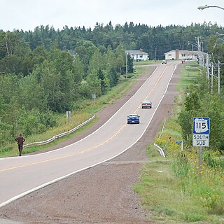
Route 115 is a highway in New Brunswick, Canada; running from a junction with Route 134 in the Lewisville neighbourhood of Moncton to Route 134 in Saint-François-de-Kent (near Bouctouche, a distance of 44 kilometres.

The 1879 Bouctouche Tornado was a tornado that struck the town of Bouctouche, New Brunswick on Wednesday, August 6, 1879.

CITA-FM

CITA-FM is a Canadian radio station, broadcasting a Christian programming format at 105.1 FM in Moncton, New Brunswick.

Kouchibouguacis River river in Canada

The Kouchibouguacis River is a river in Saint-Louis Parish, Kent County, New Brunswick, Canada. It is a tributary of the Northumberland Strait. It is not to be confused with the Kouchibouguac River running parallel to this river, about 6 kilometres (4 mi) to the north.

Route 134 is a 261 km (162 mi)-long north-south secondary highway in eastern New Brunswick, Canada. The highway is divided by into a northern and southern section by a gap in Northumberland County connected by Route 11 and Route 8.]

Wellington Parish, New Brunswick Parish in New Brunswick, Canada

Wellington is a Canadian parish in Kent County, New Brunswick.

Bouctouche Town in New Brunswick, Canada

Bouctouche is a Canadian town in Kent County, New Brunswick. In 2016, the population was 2,361.

New Brunswick Route 475 highway in New Brunswick

Route 475 is a 21-kilometre (13 mi) long west-east secondary highway in the northwest portion of New Brunswick, Canada.

Route 495 is a 23-kilometre (14 mi) long north-south secondary highway in the northwest portion of New Brunswick, Canada.

New Brunswick Route 505 highway in New Brunswick

Route 505 is a 45-kilometre (28 mi) long north-south secondary highway in the northwest portion of New Brunswick, Canada.

Sainte-Anne-de-Kent, New Brunswick human settlement in New Brunswick, Canada

Sainte-Anne-de-Kent is a settlement in New Brunswick Centered on Route 134 and Route 475. Other Routes in this community include Route 11 and Route 505. The community includes a regional hospital called Stella-Maris-De-Kent Hospital.

Route 525 is a 10-kilometre (6.2 mi) long east-west secondary highway in the northwest portion of New Brunswick, Canada.

Route 535 is a 30-kilometre (19 mi) long north-east looping secondary highway in the south east portion of New Brunswick, Canada.

Buctouche 16 First Nations reserve in New Brunswick, Canada

Buctouche 16 is a Mi'kmaq reserve in Canada located in Kent County, New Brunswick.

References

    Coordinates: 46°22′16″N64°52′40″W / 46.371095°N 64.877701°W / 46.371095; -64.877701

    Geographic coordinate system Coordinate system

    A geographic coordinate system is a coordinate system that enables every location on Earth to be specified by a set of numbers, letters or symbols. The coordinates are often chosen such that one of the numbers represents a vertical position and two or three of the numbers represent a horizontal position; alternatively, a geographic position may be expressed in a combined three-dimensional Cartesian vector. A common choice of coordinates is latitude, longitude and elevation. To specify a location on a plane requires a map projection.