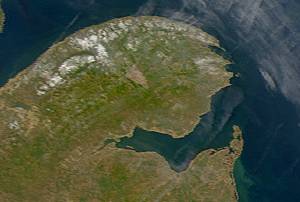
Satellite image of Chaleur Bay (NASA). Chaleur Bay is the large bay in the centre of the image; the Gaspé Peninsula is to the north and the Gulf of St. Lawrence is seen to the east.
The name of the bay is attributed to explorer Jacques Cartier (Baie des Chaleurs). It translates into English as "bay of warmth" or "bay of torrid weather".
Chaleur Bay is the 31st member of the Most Beautiful Bays of the World Club.[4][5]
Chaleur Bay is host to an unusual visual phenomenon, the Fireship of Chaleur Bay, an apparition of sorts resembling a ship on fire which has reportedly appeared at several locations in the bay. It is possibly linked to similar sightings several hundred kilometres to the south where the Fireship of Northumberland Strait has been seen in the Northumberland Strait. This may have given rise to a phantom ship legend, which dates back more than two centuries. [citation needed] The story (and witnesses) claim that a sailing ship burned in the waters north of the city of Campbellton, New Brunswick on the Restigouche River, possibly from the Battle of the Restigouche, and is visible in certain weather and light conditions. A drawing of a ghost wielding an anchor and menacing two sailors can be seen on the city's welcome sign. [citation needed]
Chaleur Bay opens to the east with its southern shore formed by the north shore of New Brunswick. The northern shore is formed by the south shore of the Gaspé Peninsula. The bay measures approximately 50km (27nmi) in width at its widest point between Bathurst and New Carlisle. The western end of the bay transitions into the estuary of the Restigouche River at Dalhousie, New Brunswick.
The shores of Chaleur Bay include numerous beaches, particularly in the south. Many rivers also form barachois or barrier beaches. The Eel River Bar is one such beach, located at the mouth of the Eel River, immediately to the west of the village of Charlo, New Brunswick. This sand bar is unique, in that it not only has fresh water on one side and salt water on the other, but it is also home to the endangered piping plover.
Tourism in the region has been driven mainly by beachgoers in the summer months. The warm ocean currents emitting from the larger Gulf of Saint Lawrence result in some of the warmest saltwater on the Atlantic coast north of Virginia.
Rivers and Bays
Chaleur Bay at New Richmond, Quebec
The estuaries of various rivers emptying into the bay create a prominent smell of salt water, notably in the estuary of the Restigouche River.
The Restigouche Estuary was designated (June, 2000) an Important Bird Area of International Significance (the first in New Brunswick) because it is the largest staging area in eastern North America for Black scoter.
The bay's shape and the steep cliffs along its northern shore sometimes create particularly windy conditions especially off Nepisiguit Bay. Under the right wind direction and speed, sea conditions on large areas of the bay can become quite treacherous. Tidal currents are generally weak, except at the mouths of some rivers and certain channels.[7] Its configuration tends to channel the wind for two reasons: the steep cliffs on its North side, and its V shape. This means that in the middle of this section, off Nepisiguit Bay, there is a zone that is particularly windy and subject to high seas if the wind is from the Northwest or the Northeast.
Tidal currents in this section rarely reach one knot, except at the mouths of some rivers and some channels.[8]
History
Immigration from Arran Island, Scotland: Bryce's The Geology of Arran 1855 notes: "Many years ago, a large population, the largest then collected in any one spot in [the island of] Arran, inhabited [Sannox] glen, and gained a scanty subsistence by fishing and by cultivating fertile plots on the sunny hill-sides. In 1832, the whole of the families amounting to 500 persons, were obliged [in the Scottish Highland Clearances] to leave the island, but were furnished with the means of reaching New Brunswick. They formed a settlement at Chaleur Bay, which became very prosperous".
Chaleur Bay is home to a variety of marine life including numerous species of ground fish and shellfish such as lobster and scallops.
Additionally, many of the bay's pristine rivers support some of the largest wild Atlantic Salmon remaining in the north Atlantic Ocean, creating a haven for sport angling.
The Gulf of St. Lawrence fringes the shores of the provinces of Quebec, New Brunswick, Nova Scotia, Prince Edward Island, Newfoundland and Labrador, in Canada, plus the islands Saint-Pierre and Miquelon, possessions of France, in North America.
Anticosti is an island located between the Jacques Cartier and Honguedo Straits, in the Gulf of St. Lawrence, in L'Île-d'Anticosti (Municipality), Minganie MRC, Côte-Nord, Quebec, Canada.
The Restigouche River is a river that flows across the northwestern part of the province of New Brunswick and the southeastern part of Quebec.
The Société des chemins de fer du Québec (SCFQ), or Quebec Railway Corporation in English, is a former Canadian railway holding company that owned several short line railways in the provinces of Quebec, Ontario, New Brunswick and Nova Scotia.
Route 138 is a major highway in the Canadian province of Quebec, following the entire north shore of the St. Lawrence River past Montreal to the temporary eastern terminus in Kegashka on the Gulf of St. Lawrence. The western terminus is in Elgin, at the border with New York State south-west of Montreal. Part of this highway is known as the Chemin du Roy, or King's Highway, which is one of the oldest highways in Canada.
Baie-Trinité is part of the Manicouagan Regional County Municipality, in Côte-Nord region, Quebec province, Canada.
Beresford is a geographic parish in Gloucester County, New Brunswick, Canada.
Charles Robin was a merchant from the Isle of Jersey, who traded between the maritime region of Canada and the British Isles.
The Battle of Restigouche was a naval battle fought in 1760 during the Seven Years' War on the Restigouche River between the British Royal Navy and the small flotilla of vessels of the French Navy, Acadian militia and Mi'kmaq militias. The loss of the French vessels, which had been sent to support and resupply the troops in New France after the fall of Quebec, marked the end of any serious attempt by France to keep hold of their colonies in North America. The battle was the last major engagement of the Mi'kmaq and Acadian militias before the Burying of the Hatchet Ceremony between the Mi'kmaq and the British.
New Brunswick is one of Canada's three Maritime provinces. While New Brunswick is one of Canada's Maritime Provinces, it differs from its neighbours both ethnoculturally and physiographically. Both Nova Scotia and Prince Edward Island are either wholly or nearly surrounded by water and the ocean, therefore, tends to define their climate, economy and culture. New Brunswick, on the other hand, although having a significant seacoast, is sheltered from the Atlantic Ocean proper and has a large interior that is removed from oceanic effects. New Brunswick, therefore, tends to be defined by its rivers rather than its seacoast.
Grande-Rivière or variation, may refer to:
The North Shore is a region in the northeastern part of the Canadian province of New Brunswick.
Shippegan is a geographic parish in Gloucester County, New Brunswick, Canada. Located in the northeastern corner of the province at the end of the Acadian Peninsula, the parish consists of the three main islands of Taylor, Lamèque, and Miscou, along with several smaller islands and tidal wetlands; Taylor Island is now joined to the mainland by an isthmus, which is crossed by a causeway.
The Gulf of St. Lawrence campaign occurred during the French and Indian War when British forces raided villages along present-day New Brunswick and the Gaspé Peninsula coast of the Gulf of Saint Lawrence. Sir Charles Hardy and Brigadier-General James Wolfe were in command of the naval and military forces respectively. After the siege of Louisbourg, Wolfe and Hardy led a force of 1,500 troops in nine vessels to the Gaspé Bay arriving there on September 5. From there they dispatched troops to Miramichi Bay, Grande-Rivière, Quebec and Pabos, and Mont-Louis, Quebec. Over the following weeks, Sir Charles Hardy took 4 sloops or schooners, destroyed about 200 fishing vessels and took about two hundred prisoners.
The ZEC des Anses is a "zone d'exploitation contrôlée" (ZEC) of 164 square kilometres (63 sq mi), located in the municipality of Chandler, in Le Rocher-Percé Regional County Municipality, in the administrative region of Gaspésie-Îles-de-la-Madeleine, in Quebec, in Canada. The economic activities of Zec focus on forestry and recreational and tourism activities.
Zec de la Rivière-Bonaventure is a "zone d'exploitation contrôlée" (ZEC) located in the non organized territory of Rivière-Bonaventure, in Bonaventure Regional County Municipality, in the administrative region Gaspésie-Îles-de-la-Madeleine, Québec, Canada. The economy of the zec is mainly based on recreational salmon fishing.
The Sentier Nepisiguit Mi'gmaq Trail is a 147 kilometre wilderness hiking and backpacking trail in New Brunswick, Canada that follows the Nepisiguit River from the Daly Point’s Nature Reserve in Bathurst to Mount Carleton Provincial Park. Officially opened for hiking in 2018, the trail is a recommissioned ancient Mi'gmaq portage route and is one of the eleven signature hiking trails in New Brunswick.
Nepisiguit Bay is located in northern New Brunswick, Canada on the southern part of the Chaleur Bay, which extends from the Atlantic Ocean and Nepisiguit Bay is a southern arm of it, stretching between Petit-Rocher and Stonehaven.
This page is based on this Wikipedia article Text is available under the CC BY-SA 4.0 license; additional terms may apply. Images, videos and audio are available under their respective licenses.