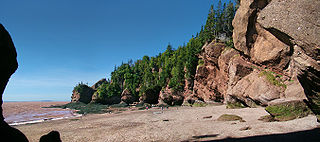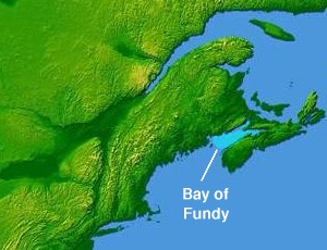
Fundy National Park is located on the Bay of Fundy, near the village of Alma, New Brunswick. The Park showcases a rugged coastline which rises up to the Canadian Highlands, the highest tides in the world and more than 25 waterfalls. The Park covers an area of 207 km2 (80 sq mi) along Goose Bay, the northwestern branch of the Bay of Fundy. When one looks across the Bay, one can see the northern Nova Scotia coast.

Passamaquoddy Bay is an inlet of the Bay of Fundy, between the U.S. state of Maine and the Canadian province of New Brunswick, at the mouth of the St. Croix River. Most of the bay lies within Canada, with its western shore bounded by Washington County, Maine. The southernmost point is formed by West Quoddy Head on the U.S. mainland in Lubec, Maine; and runs northeasterly through Campobello Island, New Brunswick, engulfing Deer Island, New Brunswick, to the New Brunswick mainland head at L'Etete, New Brunswick in Charlotte County, New Brunswick.

Chignecto Bay is an inlet of the Bay of Fundy located between the Canadian provinces of New Brunswick and Nova Scotia and separated from the waters of the Northumberland Strait by the Isthmus of Chignecto. It is a unit within the greater Gulf of Maine Watershed. Chignecto Bay forms the northeastern part of the Bay of Fundy which splits at Cape Chignecto and is delineated on the New Brunswick side by Martin Head. Chignecto bay was also the site of an unsuccessful railway and canal project of the 1880s and 1890s that would have intersected the landmass, thereby providing a transit passage between New England and Prince Edward Island. After several investigations into the feasibility of a new canal project, including most importantly by the Chignecto Canal Commission, the proposed Chignecto Canal was deemed commercially and economically unjustifiable and the project was abandoned. Some of the physical remnants of the 1880s project still continue to dot the landscape of Chignecto Bay today.

The Kennebecasis River is a tributary of the Saint John River in southern New Brunswick, Canada. The name Kennebecasis is thought to be derived from the Mi'kmaq "Kenepekachiachk", meaning "little long bay place." It runs for approximately 95 kilometres, draining an area in the Caledonia Highlands, an extension of the Appalachian Mountains, inland from the Bay of Fundy.

The Nashwaak River, located in west-central New Brunswick, Canada, is a tributary of the Saint John River. It is 113 kilometres long. The river rises from Nashwaak Lake and flows south and east through uninhabited land and rapids to the village of Stanley. From Stanley, the Nashwaak flows southeast to Nashwaak Bridge and Taymouth, then south the through several rural communities such as Durham Bridge, the historic town of Nashwaak Village and Penniac before it reaches the town of Marysville. It flows into the Saint John River opposite downtown Fredericton.
The Hammond River is a tributary of the Kennebecasis River in New Brunswick, Canada.

Hampton is a town in Kings County, New Brunswick, Canada.

Bertrand is a Canadian village in Gloucester County, New Brunswick.

St. Martins is a village on the Bay of Fundy in Saint John County, New Brunswick, Canada.

Partridge Island is a Canadian island located in the Bay of Fundy off the coast of Saint John, New Brunswick, within the city's Inner Harbour.
Lancaster was a small city situated on the west side of the Saint John River at its mouth into the Bay of Fundy.

Hopewell Cape is a Canadian village and headland in Albert County, New Brunswick at the northern end of Shepody Bay and the mouth of the Petitcodiac River.

The Big Salmon River is a small river in southern New Brunswick, Canada, that flows south into the Bay of Fundy. The river has its source to the southwest of Sussex, New Brunswick. The river flows into the Bay of Fundy near St. Martins, New Brunswick, and serves as the endpoint of the Fundy Trail.
The Fundy Islands, also known as the Fundy Isles, is a term given to a group of Canadian islands in the Bay of Fundy along the southwestern coast of New Brunswick, Canada, in the provincial county of Charlotte. There are over 25 islands within this group including several parishes including the West Isles. Some of the larger islands are inhabited year-round while some of the smaller islands may have seasonal residents. The largest of the islands is Grand Manan with the second and third largest islands being Campobello Island and Deer Island respectively. Deer Island shares its coastline with not only the Bay of Fundy, but also Passamaquoddy Bay to its north. Smaller island exist along each of the larger islands as well as within Passamaquoddy Bay and along the New Brunswick mainland. Some of these islands include White Head Island, Macs Island and Pendelton Island, Minister's Island and Hospital Island.

Coles Island is a settlement and an island in New Brunswick, Canada. The island itself is located in the Canaan River. The community is centered on Route 10, Route 715, and Route 112 intersection and extends south of the island as well. It links travelers on the #2 Highway to southern communities such as Sussex, New Brunswick, Apohaqui Saint John and the Fundy coastline.

Fort Howe was built by the British during the American Revolution shortly after the American Siege of Saint John (1777), to protect Saint John from further American raids. The 18th and 19th century British Army fortification is built in present-day New Brunswick, at the mouth of the St. John River where it empties into the Bay of Fundy. The site of the fort is now located within the city of Saint John. Fort Howe includes a replica of the blockhouse that once stood at Fort Howe. It is located approximately 250 metres to the northeast of the original structure.
The Memramcook River is a river located in Westmorland County, in southeastern New Brunswick, eastern Canada.
The Iroquois River is a tributary of the Saint John River emptying in New Brunswick, in Canada. This river flows into the Notre Dame Mountains, in the municipality of Dégelis, Quebec, in Temiscouata Regional County Municipality (RCM), in administrative region of Bas-Saint-Laurent, in Quebec; and in the Madawaska County, in New Brunswick, in Canada.

The River Baker is a tributary of the Saint John River, flowing in Madawaska County, in the northwest part of the New Brunswick, in Canada.


