Northumberland County is located in northeastern New Brunswick, Canada.

The Miramichi River is a river located in the east-central part of New Brunswick, Canada. The river drains into Miramichi Bay in the Gulf of St. Lawrence. The name may have been derived from the Montagnais words "Maissimeu Assi", and it is today the namesake of the Miramichi Herald at the Canadian Heraldic Authority.

At 817m, Mount Carleton, in Mount Carleton Provincial Park is the highest peak in the Canadian province of New Brunswick, and the Maritime Provinces. It is one of the highlights of the Canadian portion of the International Appalachian Trail. It is also part of the eighth and final section of the Nepisiguit Mi'gmaq Trail. The mountain was named after Thomas Carleton, New Brunswick's first lieutenant governor, and forms part of the Notre Dame Mountains chain, which is visible on Map 24 of the NB Atlas.
The name "Miramichi" was first applied to a region in the northeast of New Brunswick, Canada, and has since been applied to other places in Canada and the United States. Although other interpretations have been suggested, it is believed that "Miramichi" was derived from the Montagnais words "Maissimeu Assi", and was perhaps introduced for use in European languages by Jacques Cartier in 1535.

The Northwest Miramichi River or Elmunokun is a river in New Brunswick, Canada. The Mi'kmaq referred to the river as Elmunokun, possibly meaning "a beaver hole" in reference to a deep pool in the river, just below the mouth of the Big Sevogle River, its second largest tributary, after the Little Southwest Miramichi.
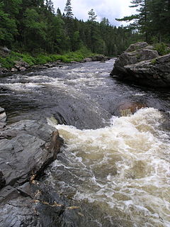
"Push and Be Damned Rapids" is the evocative name for rapids on the Southwest Miramichi River, one of the many tributaries of the Miramichi River, New Brunswick, Canada, near the village of Juniper.
The Little Southwest Miramichi River is a river in Northumberland County, New Brunswick, Canada. In Mi'kmaq it is referred to as "Tooadook".

The Renous River is a tributary of the Southwest Miramichi River in New Brunswick, Canada.

The Dungarvon River is a tributary of the Renous River in New Brunswick, Canada.
Beresford is a town in Gloucester County, New Brunswick, Canada.
Renous-Quarryville is a Canadian local service district in Northumberland County, New Brunswick. It is located 25 mi upstream of Miramichi, and is situated where the Renous River, and the Indiantown brook. discharges into the Southwest Miramichi River. It is named for the Renous river, and settlement, as well as Quarryville's quarry, hence the name "Renous-Quarryville local service district."

The Big Sevogle River is a Canadian river in central New Brunswick. It consists of two branches, the North Sevogle and South Sevogle Rivers. Below the confluence of these rivers at the Square Forks, the river is properly referred to as the Big Sevogle River. This name serves to distinguish it from the "Little Sevogle River", a much smaller tributary to the Northwest Miramichi River.

Big Bald Mountain is a prominent peak in the Canadian province of New Brunswick. It lies adjacent to Colonels Mountain, east of the Christmas Mountains, and near the headwaters of the Northwest Miramichi River, the Sevogle River, and the South Branch Nepisiguit River. It is a well-known feature, in part because of its height, but especially because of its bald summit.

The Christmas Mountains are a series of rounded peaks in northern New Brunswick, Canada, at the headwaters of North Pole Stream and the Little Southwest Miramichi River, west of Big Bald Mountain, and south of Mount Carleton. The mountains, in part, separate the Miramichi River watershed from the watersheds of the Serpentine River and the Nepisiguit River.

The Nepisiguit River is a major river in northern New Brunswick, Canada, which enters the sea at the city of Bathurst, into the Nepisiguit Bay, part of the Bay of Chaleur.
North Pole Stream is a tributary to the Little Southwest Miramichi River, with its headwaters in the Christmas Mountains of north-central, New Brunswick, Canada. It is an important spawning stream for Atlantic Salmon, and renowned among fly fishers.
Tuadook River is a Canadian river in Northumberland County, New Brunswick. The river drains northeastward from Holmes Lake and Tuadook Lake into the Little Southwest Miramichi River. The name is derived from the original Mi'kmaq name for the Little Southwest Miramichi River

Southesk is a civil parish in Northumberland County, New Brunswick, Canada.
Derby is a civil parish in Northumberland County, New Brunswick, Canada.

Stanley is a civil parish in York County, New Brunswick, Canada.