
Northumberland County is located in northeastern New Brunswick, Canada.

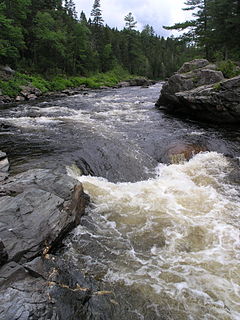
The Northwest Miramichi River or Elmunokun is a river in New Brunswick, Canada. The Mi'kmaq referred to the river as Elmunokun, possibly meaning "a beaver hole" in reference to a deep pool in the river, just below the mouth of the Big Sevogle River, its second largest tributary, after the Little Southwest Miramichi.
The Little Southwest Miramichi River is a Canadian river in Northumberland County, New Brunswick. In Mi'kmaq it is referred to as "Tooadook".
The Bartholomew River is a tributary of the Main Southwest Miramichi River in New Brunswick, Canada.
Boiestown is a Canadian community in the rural community of Upper Miramichi in Northumberland County, New Brunswick.

The Sevogle River is a Canadian river in central New Brunswick. It consists of two branches, the North Sevogle and South Sevogle Rivers. Below the confluence of these rivers at the Square Forks, the river is properly referred to as the "Big Sevogle River". This name serves to distinguish it from the "Little Sevogle River", a much smaller tributary to the Northwest Miramichi River.

Big Bald Mountain is a prominent peak in the Canadian province of New Brunswick. It lies adjacent to Colonels Mountain, east of the Christmas Mountains, and near the headwaters of the Northwest Miramichi River, the Sevogle River, and the South Branch Nepisiguit River. It is a well-known feature, in part because of its height, but especially because of its bald summit.
The Christmas Mountains are a series of rounded peaks in northern New Brunswick, Canada, at the headwaters of North Pole Stream and the Little Southwest Miramichi River, west of Big Bald Mountain, and south of Mount Carleton. The mountains, in part, separate the Miramichi River watershed from the watersheds of the Serpentine River and the Nepisiguit River.

North Pole Stream is a tributary to the Little Southwest Miramichi River, with its headwaters in the Christmas Mountains of north-central, New Brunswick, Canada. It is an important spawning stream for Atlantic Salmon, and renowned among fly fishers.

The Eel Ground Band or Eel Ground First Nation is a Mi'kmaq First Nation band government of 977 people located on the Miramichi River in northern New Brunswick, Canada. The community comprises three reserves.
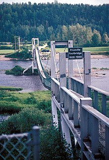
McNamee/Priceville Footbridge is the longest suspension footbridge in New Brunswick, Canada. It spans the Southwest Miramichi River at McNamee, approximately 12 km west of Doaktown, New Brunswick.
Red Bank, New Brunswick is a small rural community in Northumberland County, New Brunswick, Canada. It is located approximately 20 km west of Miramichi, New Brunswick, at the mouth of the Little Southwest Miramichi River, at its confluence with the Northwest Miramichi River. The community lies on the southwest bank of the NW Miramichi and opposite its sister community Sunny Corner around the intersection of Route 420 and Route 425.
Holmes Lake is a Canadian lake in Northumberland County, New Brunswick.
Tuadook River is a Canadian river in Northumberland County, New Brunswick. The river drains northeastward from Holmes Lake and Tuadook Lake into the Little Southwest Miramichi River. The name is derived from the original Mi'kmaq name for the Little Southwest Miramichi River
Sunny Corner, New Brunswick is a rural settlement in Northumberland County, New Brunswick, Canada. It is located approximately 35km west of Miramichi, New Brunswick, on the northeast bank of the Northwest Miramichi River, opposite its sister community, Red Bank. The community has an Irving gas station, a Royal Canadian Legion, a Lions Club which includes a bowling alley, a government garage, a police station serviced by the RCMP, a volunteer fire department, a hockey rink, and a seniors home.

Northesk is a Canadian parish in Northumberland County, New Brunswick.
Upper Miramichi is a Canadian rural community in Northumberland and York Counties, New Brunswick.


