Bonaventure River

Last updated
Bonaventure River
Rivière Bonaventure
Barachois de Bonaventure.jpg
Mouth of the Bonaventure
Country Canada
Province Quebec
Region Gaspésie–Îles-de-la-Madeleine
Tributaries
 - left Hall River
 - right West Bonaventure River
Source Chic-Choc Mountains
 - location Mont-Albert, Quebec
 - elevation 600 m (1,969 ft)
 - coordinates 48°53′00″N65°32′30″W / 48.88333°N 65.54167°W / 48.88333; -65.54167
Mouth Chaleur Bay
 - location Bonaventure, Quebec
 - elevation 0 m (0 ft)
 - coordinates 48°02′00″N65°29′00″W / 48.03333°N 65.48333°W / 48.03333; -65.48333 Coordinates: 48°02′00″N65°29′00″W / 48.03333°N 65.48333°W / 48.03333; -65.48333
Length 115 km (71 mi) [1]

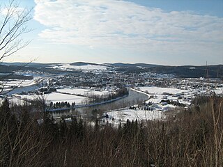
The Bonaventure River is a river in the Gaspé Peninsula of Quebec, Canada. It rises in the Chic-Choc Mountains and flows south to empty into Baie des Chaleurs near the town of Bonaventure, Quebec. The river is about 115 km (71 mi) long. [1]

Gaspé Peninsula Region in Quebec, Canada

The Gaspésie, or Gaspé Peninsula, the Gaspé or Gaspesia, is a peninsula along the south shore of the Saint Lawrence River to the east of the Matapedia Valley in Quebec, Canada, that extends into the Gulf of Saint Lawrence. It is separated from New Brunswick on its southern side by the Baie des Chaleurs and the Restigouche River. The name Gaspé comes from the Mi'kmaq word gespe'g, meaning "end", referring to the end of the land.

Quebec Province of Canada

Quebec is one of the thirteen provinces and territories of Canada. It is bordered to the west by the province of Ontario and the bodies of water James Bay and Hudson Bay; to the north by Hudson Strait and Ungava Bay; to the east by the Gulf of Saint Lawrence and the province of Newfoundland and Labrador; and to the south by the province of New Brunswick and the U.S. states of Maine, New Hampshire, Vermont, and New York. It also shares maritime borders with Nunavut, Prince Edward Island, and Nova Scotia. Quebec is Canada's largest province by area and its second-largest administrative division; only the territory of Nunavut is larger. It is historically and politically considered to be part of Central Canada.

Chic-Choc Mountains

The Chic-Choc Mountains, also spelled Shick Shocks, is a mountain range in the central region of the Gaspé Peninsula in Quebec, Canada. It is a part of the Notre Dame Mountains, which is a continuation of the Appalachian Mountains.

The indigenous Mi'kmaq called the river Wagamet, meaning "clear water". [2] The river is still noted for its clear, cold water, making it well known as a great place for Atlantic Salmon fishing and recreational canoeing.

Indigenous peoples of the Americas Pre-Columbian inhabitants of North, Central, and South America and their descendants

The indigenous peoples of the Americas are the Pre-Columbian peoples of North, Central and South America and their descendants.

Canoeing paddle sport in which you kneel or sit facing forward in an open or closed-decked canoe, and propel yourself with a single-bladed paddle, under your own power

Canoeing is an activity which involves paddling a canoe with a single-bladed paddle. Common meanings of the term are limited to when the canoeing is the central purpose of the activity. Broader meanings include when it is combined with other activities such as canoe camping, or where canoeing is merely a transportation method used to accomplish other activities. Most present-day canoeing is done as or as a part of a sport or recreational activity. In some parts of Europe canoeing refers to both canoeing and kayaking, with a canoe being called an Open canoe.

The origin of the river's name is uncertain. It may come from the French bonne aventure (meaning "good fortune"); or named in honour of Simon-Pierre Denys de Bonaventure; or named after the ship Bonaventure of Lord La Court de Pré-Ravillon et de Granpré who entered the Gulf of Saint Lawrence in 1591. In any case, this name was already in use in 1697 when Governor Louis de Buade de Frontenac and Superintendent Jean Bochart de Champigny granted both sides of the river as the Seignory of the Bonavanture [ sic ] River to Charles-Henry de La Croix. [1] [3]

Simon-Pierre Denys de Bonaventure was an officer in the colonial troupes de la marine of New France and was heavily involved with the events of Acadia from 1685 until his death. He participated in the Naval battle off St. John (1691), the Naval battle off St. John (1696) and the Siege of Pemaquid (1696). He governed Acadia after the death of the governor Jacques-François de Monbeton de Brouillan until the appointment of the new governor, Daniel d'Auger de Subercase on 22 May 1706.

Louis de Buade de Frontenac Governor of New France

Louis de Buade, Comte de Frontenac et de Palluau was a French soldier, courtier, and Governor General of New France from 1672 to 1682 and from 1689 to his death in 1698. He established a number of forts on the Great Lakes and engaged in a series of battles against the English and the Iroquois.

Jean Bochart de Champigny, Sieur de Noroy et de Verneuil, chevalier, was Superintendent of Finances from 1624 to 1626 and intendant of New France from 1686 to 1702. He was the son of Jean Bochart de Champigny, intendant of Rouen, and Marie Boivin.
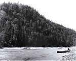
See also

Related Research Articles

The Miꞌkmaq language is an Eastern Algonquian language spoken by nearly 11,000 Miꞌkmaq in Canada and the United States out of a total ethnic Miꞌkmaq population of roughly 20,000. The word Miꞌkmaq is a plural word meaning 'my friends' ; the adjectival form is Míkmaw. The native name of the language is Lnuismk, Míkmawísimk or Míkmwei.

Chandler, Quebec City in Quebec, Canada

Chandler is a town in the Gaspésie–Îles-de-la-Madeleine region of Quebec, Canada. It is the second-most populous town on the Gaspé Peninsula after the Town of Gaspé. It was known as Pabos between June 27, 2001 and May 4, 2002.

Matapedia River river of Matapedia Valley, Quebec, Canada

The Matapedia River is a river in the Matapedia Valley in the province of Quebec, Canada. It runs on 65 kilometres (40 mi) from Matapedia Lake down to the village of Matapédia where it empties into the left bank of Restigouche River on the provincial border of New Brunswick.

Cascapédia River river in Gaspésie, Quebec, Canada

The Cascapédia River is a river in the Gaspé Peninsula of Quebec, Canada, which has its source at Lake Cascapedia, fed by streams of the Chic-Choc Mountains, and empties into Cascapedia Bay, a small bay of Chaleur Bay. The river is about 120 kilometres (75 mi) long. At times, it is also called Grand Cascapédia River to differentiate it from the Little Cascapédia River which empties into the same bay just to the east.

Bonaventure, Quebec City in Quebec, Canada

Bonaventure is a town on the Gaspé Peninsula in the Bonaventure Regional County Municipality of Quebec. It is located on Baie des Chaleurs near the mouth of the Bonaventure River. The town is situated on Route 132 between Saint-Siméon and New Carlisle.

Amqui City in Quebec, Canada

Amqui is a town in eastern Quebec, Canada, at the base of the Gaspé peninsula in Bas-Saint-Laurent. Located at the confluence of the Humqui and Matapédia Rivers, it is the seat of La Matapédia Regional County Municipality. The main access road is Quebec Route 132.

Dégelis City in Quebec, Canada

Dégelis is a city in Témiscouata Regional County Municipality within the Bas-Saint-Laurent region of Quebec. Its population in the Canada 2011 Census was 3,051. The Madawaska River flows from Lake Témiscouata, through Degelis, to join the Saint John River at 32 kilometres (20 mi) to the East at Edmundston, New Brunswick.

Matapédia, Quebec Municipality in Quebec, Canada

Matapédia is a municipality at the southern tip of the Gaspé Peninsula, in Eastern Quebec, Canada. Matapédia is located along Quebec Route 132 on the border of New Brunswick.

Causapscal City in Quebec, Canada

Causapscal is a city in the Canadian province of Quebec, located in La Matapédia Regional County Municipality. It is located at the confluence of the Matapédia and Causapscal Rivers, along Quebec Route 132, approximately halfway between Mont-Joli and Campbellton, New Brunswick. It is served by the Causapscal railway station and the Causapscal Airport.

Little Whale River river flowing into East coast of Hudsons Bay, in Nunavik, administrative region of Nord-du-Québec, in Quebec, in Canada

The Little Whale River is a river in Nunavik, Quebec, Canada. With an area of 15,900 square kilometres (6,100 sq mi), it is ranked as the 35th largest river basin in Quebec.

Cascapédia–Saint-Jules Municipality in Quebec, Canada

Cascapédia–Saint-Jules is a municipality in Quebec, Canada.

Maria, Quebec Municipality in Quebec, Canada

Maria is a municipality in Quebec, Canada.

Lac-Lapeyrère, Quebec Unorganized territory in Quebec, Canada

Lake Lapeyrère is a municipal unorganized territory, part of Portneuf in Quebec, (Canada). The RCM is included in the administrative region of the Capitale-Nationale. This area of the north shore of St. Lawrence river and the west bank of the Batiscan River is located about 75 kilometers northeast of Shawinigan, Quebec. The unorganized territory Lac-Lapeyrère includes Lapeyrère Township, which was established in 1907. The canton is one sector of Portneuf Wildlife Reserve and Zec Tawachiche. Territory Lac-Lapeyrère has several major water bodies including lakes Garneau, Travers, Robinson, Casgrain, Tage and Lapeyrère, and is drained to the east by the Batiscan River.

Matane Town in Quebec, Canada

Matane is a town on the Gaspé Peninsula in Quebec, Canada, on the south shore of the Saint Lawrence River at the mouth of the Matane River. The town is the seat for the La Matanie Regional County Municipality.

Rivière-Bonaventure, Quebec Unorganized territory in Quebec, Canada

Rivière-Bonaventure is an unorganized territory in the Gaspésie–Îles-de-la-Madeleine region of Quebec, Canada.

Rivière-Nouvelle, Quebec Unorganized territory in Quebec, Canada

Rivière-Nouvelle is an unorganized territory in the Gaspésie–Îles-de-la-Madeleine region of Quebec, Canada.

Zec de la Petite-Rivière-Cascapédia

Zec Petite-Rivière-Cascapédia is a "zone d'exploitation contrôlée" (ZEC) in the unorganized territory of Rivière-Bonaventure, in Bonaventure Regional County Municipality, in the administrative region Gaspésie-Îles-de-la-Madeleine, in Quebec, in Canada. The main purpose of the ZEC is managing salmon fishing.

Zec de la Rivière-Bonaventure Controlled harvesting zone (ZEC) in Quebec, in Canada

Zec de la Rivière-Bonaventure is a "zone d'exploitation contrôlée" (ZEC) located in the non organized territory of Rivière-Bonaventure, in Bonaventure Regional County Municipality, in the administrative region Gaspésie-Îles-de-la-Madeleine, Québec, Canada. The economy of the zec is mainly based on recreational salmon fisching.

Carleton-sur-Mer City in Quebec, Canada

Carleton-sur-Mer is the fifth largest town of the Gaspésie's south shore, in southeastern Quebec, Canada, located on Route 132, along the Baie des Chaleurs.

Bazin River tributary of Gatineau river, flowing La Tuque (Mauricie region) and in RCM of Antoine-Labelle, in Quebec, in Canada

The Bazin River is a flowing stream in the La Tuque area of the La Tuque administrative authority of Mauricie, and will flow into the Gatineau River in the unorganized territory of Lac-Oscar, in the Regional County Municipality (RCM) of Antoine-Labelle, in Laurentides, in Quebec, in Canada.

References