Chic-Choc Mountains

Last updated
Chic-Choc Mountains
Montalbertgaspesie.jpg
Highest point
Peak Mount Jacques-Cartier
Elevation 1,268 m (4,160 ft)
Coordinates 48°59′26″N65°56′33″W / 48.99056°N 65.94250°W / 48.99056; -65.94250
Dimensions
Length95 km (59 mi)East-West
Width10 km (6.2 mi)
Geography
Canada Quebec relief location map-conic proj.jpg
Red triangle with thick white border.svg
Canada relief map 2.svg
Red triangle with thick white border.svg
CountryCanada
RegionQuebec
Range coordinates 48°55′N66°00′W / 48.917°N 66.000°W / 48.917; -66.000
Parent range Notre Dame Mountains

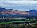
The Chic-Choc Mountains, also spelled Shick Shocks, form a mountain range in the central region of the Gaspe Peninsula in Quebec, Canada. It is a part of the Notre Dame Mountains, which are a subrange of the Appalachians. [1]

Contents

History

The name Chic-Chocs comes from the Mi'kmaq word sigsôg, meaning "crags" or "rocky mountains."[ disputed ] It has undergone many different spellings over time, including Chikchâks (1836), Shick-shock (1857), and Chick-Saws (1863). [1]

Geography

The Chic-Chocs run parallel to the St. Lawrence River and are located some 20 to 40 kilometers inland. They are a narrow band of mountains approximately 95 kilometres (59 mi) long and 10 kilometres (6.2 mi) wide. [1] The Chic-Chocs are heavily eroded, with rounded, flattened tops and steep sides. Over 32 mountains in the range have peaks higher than 1,000 metres (3,300 ft); the highest is Mount Jacques-Cartier at 1,268 metres (4,160 ft). Caribou can be found in the plateaus of this region.

Tourism

Although visited by just a few tourists, Chic-Choc Mountains became much more popular in the late 1990s as backcountry skiing gained popularity in Eastern Canada.

Some of the most popular backcountry skiing areas in the region include Mont Hogs Back, Mont Albert, Champ Mars, Mount Logan, and Mines Madeleine.

The mountains near Mont Saint Pierre are a destination for ice climbers. [2]

A network of trails, including the International Appalachian Trail, passes through these mountains. Quebec's Parc national de la Gaspésie protects most of the mountain range.

See also

Related Research Articles

<span class="mw-page-title-main">Gaspé Peninsula</span> Peninsula in Quebec, Canada

The Gaspé Peninsula, also known as Gaspesia, is a peninsula along the south shore of the St. Lawrence River that extends from the Matapedia Valley in Quebec, Canada, into the Gulf of St. Lawrence. It is separated from New Brunswick on its southern side by Chaleur Bay and the Restigouche River. The name Gaspé comes from the Mi'kmaq word gespe'g, meaning "end", referring to the end of the land.

<span class="mw-page-title-main">Laurentian Mountains</span> Mountain range in Canada

The Laurentian Mountains, also known as the Laurentians or Laurentides, are a mountain range in Canada. The range is 1,448 km long and ranges in height from 500 m with peaks over 1,000 m. The Laurentian Mountains extend across Labrador and Quebec within the Laurentian Upland, which contains foothills in northeastern Ontario. The range is located near the rivers of Ottawa, St. Lawrence, and Saguenay. The Laurentian Mountains primarily stretch across multiple regions in Quebec, with geologic formations such as the Jacques-Cartier Massif located within the range.

<span class="mw-page-title-main">Notre Dame Mountains</span> Portion of the Appalachian Mountains in Quebec and Vermont

The Notre Dame Mountains are a portion of the Appalachian Mountains, extending from the Gaspé Peninsula of Quebec to the Green Mountains of Vermont.

<span class="mw-page-title-main">Quebec Route 299</span> Highway in Quebec

Route 299 is a 137-kilometre (85 mi) long two-lane highway which cuts through the Appalachian Mountains in Quebec, Canada. It starts at the junction of Route 132 in Cascapédia–Saint-Jules, runs through Gaspésie National Park and ends at the junction of Route 132 in Sainte-Anne-des-Monts. It is an isolated highway with only a few small settlements along the way.

<span class="mw-page-title-main">Sainte-Anne-des-Monts</span> City in Quebec, Canada

Sainte-Anne-des-Monts is a city in the Gaspésie–Îles-de-la-Madeleine region of the province of Quebec in Canada.

<span class="mw-page-title-main">Gaspésie National Park</span> Canadian provincial park in Quebec

Gaspésie National Park is a provincial park located south of the town of Sainte-Anne-des-Monts, Quebec, Canada in the inland of the Gaspé peninsula. The park contains the highest peak of the Appalachian Mountains in Canada, Mont Jacques-Cartier, 1,270 metres (4,170 ft) above sea level. In addition, the park contains the only population of Caribou found south of the Saint Lawrence River in Canada.

<span class="mw-page-title-main">Mount Jacques-Cartier</span>

Mount Jacques-Cartier is a mountain in the Chic-Choc Mountains range in eastern Quebec, Canada. At 1,268 m (4,160 ft), it is the tallest mountain in southern Quebec, and the highest mountain in the Canadian Appalachians.

<span class="mw-page-title-main">Mount Albert (Quebec)</span>

Mont Albert is a mountain in the Chic-Choc range in the Gaspésie National Park in the Gaspé Peninsula of eastern Quebec, Canada. At 1,151 m (3,776 ft), it is one of the highest mountains in southern Quebec, and is popular for hiking.

<span class="mw-page-title-main">Mont-Albert, Quebec</span> Unorganized territory in Quebec, Canada

Mont-Albert is an unorganized territory in the Gaspésie–Îles-de-la-Madeleine region of Quebec, Canada.

<span class="mw-page-title-main">Sautauriski Mountain</span>

The Sautauriski mountain culminates at 727 metres (2,385 ft) in the southern part of Jacques-Cartier National Park, in the municipality of Stoneham-et-Tewkesbury, in the regional county municipality (MRC) of La Jacques-Cartier, in the administrative region of Capitale-Nationale, in Quebec, Canada.

<span class="mw-page-title-main">Andante Mount</span>

The Mont Andante culminates at 810 metres (2,660 ft) in the western part of Jacques-Cartier National Park, in the unorganized territory of Lac-Croche, in the La Jacques-Cartier Regional County Municipality, in the administrative region of Capitale-Nationale, in Quebec, Canada.

The Rivière des Grands Méchins Ouest is a tributary of the west bank of the Rivière des Grands Méchins, which flows north to the southern coast of the Saint Lawrence River where it flows into the municipality Les Méchins.

<span class="mw-page-title-main">Mont Xalibu</span>

Mount Xalibu is a mountain located in the unorganized territory of Mont-Albert, in Quebec. Culminating at 1,120 metres (3,670 ft) above sea level, it is one of the highest peaks in the Notre Dame Mountains. It is located in Gaspésie National Park.

The McGerrigle Mountains are a mountain range in the central part of Gaspésie in eastern Quebec, Canada. It is the main constituent of the Chic-Choc Mountains belonging to the Notre Dame Mountains, a subrange of the Appalachian chain.

<span class="mw-page-title-main">Chic-Chocs Wildlife Reserve</span> Canadian wildlife refuge in Quebec

The Réserve faunique des Chic-Chocs is a wildlife reserve of Quebec located in east of Parc national de la Gaspésie, in the administrative region of Gaspésie–Îles-de-la-Madeleine, in Quebec, Canada.

<span class="mw-page-title-main">Mount Logan (Quebec)</span> Mountain in Quebec, Canada

Mount Logan is a mountain on the Gaspé Peninsula, in Quebec, Canada. Part of the Chic-Choc Mountains, Mount Logan rises 1,150 metres (3,773 ft) above sea level, making it the highest point in the Bas-Saint-Laurent region and one of the few Quebec peaks over 1,100 metres (3,609 ft).

The Mont Olivine is a mountain in Gaspésie National Park, in the unincorporated territory of Mont-Albert, in the La Haute-Gaspésie Regional County Municipality (MRC), in the region of Gaspésie–Îles-de-la-Madeleine, in Quebec, in Canada.

<span class="mw-page-title-main">Mount Lyall (Quebec)</span> Mount in Gaspésie, in Quebec, Canada

Mont Lyall is a mountain in Gaspésie National Park, in the unorganized territory of Mont-Albert, in the La Haute-Gaspésie Regional County Municipality, in the region of Gaspésie–Îles-de-la-Madeleine, in Quebec, in Canada. It is part of the Chic-Choc Mountains. Mont Lyall is located on an outcrop of land on the west shore of Lac Saint-Anne.

<span class="mw-page-title-main">Sainte-Anne River (La Haute-Gaspésie)</span> River in Gaspésie, in Quebec, Canada

The Sainte-Anne River is a tributary of the south coast of the St. Lawrence River located at Gaspésie-Îles-de-la-Madeleine in the La Haute-Gaspésie Regional County Municipality, in Quebec, in Canada.

References

  1. 1 2 3 "Monts Chic-Chocs". Banque de noms de lieux du Québec (in French). Commission de Toponymie. Retrieved 1 Feb 2011.
  2. Pellett, Alden. "Ice by the Sea". Climbing Magazine. Retrieved 2019-04-24.